Shawnee County, Kansas facts for kids
Quick facts for kids
Shawnee County
|
|||
|---|---|---|---|

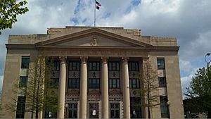
United States Post Office and Historic Courthouse in Topeka (2013)
|
|||
|
|||

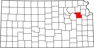
Location within the U.S. state of Kansas
|
|||
 Kansas's location within the U.S. |
|||
| Country | |||
| State | |||
| Founded | August 25, 1855 | ||
| Named for | Shawnee people | ||
| Seat | Topeka | ||
| Largest city | Topeka | ||
| Area | |||
| • Total | 556 sq mi (1,440 km2) | ||
| • Land | 544 sq mi (1,410 km2) | ||
| • Water | 12 sq mi (30 km2) 2.1% | ||
| Population
(2020)
|
|||
| • Total | 178,909 | ||
| • Estimate
(2021)
|
178,264 |
||
| • Density | 328.9/sq mi (127.0/km2) | ||
| Time zone | UTC−6 (Central) | ||
| • Summer (DST) | UTC−5 (CDT) | ||
| Congressional district | 2nd | ||
Shawnee County is a place in northeast Kansas, located in the central part of the United States. The main city and county seat is Topeka, which is also the state capital. In 2020, about 178,909 people lived here, making it the third-biggest county in Kansas. Shawnee County was one of the first 33 counties created in 1855. It was named after the Shawnee tribe, a group of Native American people.
Contents
A Look Back: Shawnee County's History
How Kansas Began
For thousands of years, the Great Plains of North America were home to Native Americans who moved around a lot. In the 16th to 18th centuries, France claimed large parts of North America. Later, in 1762, France secretly gave this land to Spain after a war.
In 1802, Spain gave most of the land back to France. Then, in 1803, the United States bought a huge area, including most of what is now Kansas, from France. This was part of the Louisiana Purchase, a very important deal.
Shawnee County is Formed
In 1854, the Kansas Territory was set up. Then, in 1861, Kansas officially became the 34th U.S. state. Shawnee County itself was created in 1855.
Before 1854, the Shawnee, Kansas, and Pottawatomie Native American tribes lived in the area. The first white settler arrived in 1830. His name was Frederick Choteau, and he opened a trading post. When Shawnee County was created in 1855, about 250 people lived there.
The county was named after the Shawnee tribe. At first, Shawnee County's borders were south of the Kansas River. Later, the borders were changed to make Topeka the center of the county.
County Government and Courthouses
The first meeting of the Shawnee County Board of Commissioners happened in 1855. Tecumseh was the first county seat, and its courthouse opened in 1856. In 1858, people voted to make Topeka the county seat instead. A new courthouse was built in Topeka in 1867.
By 1896, the county had over 50,000 residents, so a bigger courthouse was built. The current courthouse opened in 1965.
Meaning of Local Names
Many places in Shawnee County are named after Native American words or important people.
- Shawnee County: Named after the Shawnee tribe.
- Topeka: Means "a good place to grow potatoes" (prairie potatoes).
- Wakarusa: Means "river of big weeds."
- Shunganunga: Means "the race course."
- Menoken: Means "a fine growth."
- Half-Day Creek: Named after a Pottawatomie chief.
- Mission Creek: Named after an old Kaw mission that was on its banks.
- Blacksmith Creek: Named after a Kaw blacksmith shop.
- Soldier Creek: Soldiers traveling between forts often camped along its banks.
Exploring Shawnee County's Geography
Shawnee County is in the northeastern part of Kansas. It is about 556 square miles in total. Most of this area, 544 square miles, is land. The rest, about 12 square miles, is water.
Neighboring Counties
Shawnee County shares its borders with these other counties:
- Jackson County - to the north
- Jefferson County - to the northeast
- Douglas County - to the southeast
- Osage County - to the south
- Wabaunsee County - to the west
- Pottawatomie County - to the northwest
Rivers and Land
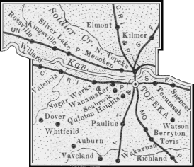
The Kansas River flows east through the county, just north of the center. The city of Topeka is mostly south of this river. While there isn't much boat traffic, the river is used a lot for watering crops. Many smaller creeks flow into the Kansas River, like Cross, Soldier, Mission, Indian, and Shunganunga Creeks. The Wakarusa River is in the southern part of the county.
The soil in Shawnee County is very rich and dark. Underneath the soil, there is limestone. You can also find clay and small amounts of coal.
The western part of the county has hills, and the Flint Hills are a few miles further west. Burnett's Mound is a notable hill in southwest Topeka. Most of the land is prairie (grasslands), with some wooded areas along the rivers and creeks. Common trees include elm, cottonwood, and oak.
Townships and Cities
Shawnee County is divided into twelve areas called townships. The city of Topeka is a large city and is separate from these townships for census purposes. It covers more than 10% of the county's land.
Besides Topeka, there are four other cities in the county:
Many townships were named after their first settlers, nearby features, or other towns. For example, Tecumseh Township was named after the famous Shawnee chief. Menoken Township's name comes from a Native American word meaning "fine growth."
People of Shawnee County

In 2020, Shawnee County had 178,909 people. The area around Topeka, including Shawnee County, had an estimated population of 232,670 in 2021.
In 2000, there were about 68,920 households. Many households (30.70%) had children under 18 living with them. The average household had 2.39 people.
The median age in the county was 37 years old. About 25.30% of the people were under 18. The median income for a household was $40,988. About 9.60% of the population lived below the poverty line.
Fun Things to See and Do
Places to Visit
- Kansas State Capitol: This impressive building in downtown Topeka is where the Kansas Legislature meets. It was built between 1866 and 1903.
- Kansas Children's Discovery Center: A great place for kids to learn and play, located in Gage Park.
- Topeka Zoo: Also in Gage Park, this zoo is famous for its eagles.
- Truckhenge: This is a unique outdoor art park located east of Topeka.
- Lake Shawnee: A popular spot in southeast Topeka with playgrounds, a swimming beach, trails, a golf course, and campgrounds.
Learning and Schools
Colleges and Universities
Vocational and Technical Schools
- Washburn Institute of Technology
School Districts
Shawnee County has several school districts that serve different areas:
- Kaw Valley USD 321 - Serves Willard and Rossville.
- Mission Valley USD 330 - Serves Dover.
- Seaman USD 345 - Serves Elmont and North Topeka.
- Silver Lake USD 372 - Serves Silver Lake.
- Auburn-Washburn USD 437 - Serves Auburn, Wakarusa, Pauline, and parts of Western and Southwestern Topeka.
- Shawnee Heights USD 450 - Serves Tecumseh, Berryton, and parts of Eastern and Southeastern Topeka.
- Topeka USD 501 - Serves Central Topeka.
Public Libraries
National Historic Site
- Brown v. Board of Education National Historic Site: This site is important because it tells the story of the Supreme Court case that ended segregation in public schools.
Getting Around: Transportation
Major highways cross Shawnee County, including Interstate 70, U.S. Route 75, U.S. Route 40, and U.S. Route 24.
Forbes Field is an Air National Guard base and airport south of Topeka. Another airport in the county is Philip Billard Municipal Airport.
Communities in Shawnee County
Shawnee County has several cities and smaller communities.
Cities
- Auburn
- Rossville
- Silver Lake
- Topeka (the county seat and state capital)
- Willard‡ (part of this city is in another county)
Unincorporated Communities
These are smaller communities that are not officially cities:
- Berryton
- Dover
- Elmont
- Kiro
- Montara
- Pauline
- Tecumseh† (a Census-Designated Place)
- Wakarusa† (a Census-Designated Place)
- Watson
Ghost Town
- Richland: This used to be a town but was bought by the U.S. Army Corps of Engineers in the 1960s for the creation of Clinton Lake. The town was emptied and its buildings were taken down by 1974.
See also
 In Spanish: Condado de Shawnee para niños
 | Delilah Pierce |
 | Gordon Parks |
 | Augusta Savage |
 | Charles Ethan Porter |


