Jefferson County, Kansas facts for kids
Quick facts for kids
Jefferson County
|
|
|---|---|

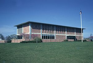
Jefferson County Courthouse in Oskaloosa (1971)
|
|

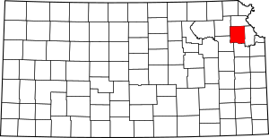
Location within the U.S. state of Kansas
|
|
 Kansas's location within the U.S. |
|
| Country | |
| State | |
| Founded | August 25, 1855 |
| Named for | Thomas Jefferson |
| Seat | Oskaloosa |
| Largest city | Valley Falls |
| Area | |
| • Total | 557 sq mi (1,440 km2) |
| • Land | 533 sq mi (1,380 km2) |
| • Water | 24 sq mi (60 km2) 4.3%% |
| Population
(2020)
|
|
| • Total | 18,368 |
| • Estimate
(2021)
|
18,411 |
| • Density | 34.5/sq mi (13.3/km2) |
| Time zone | UTC−6 (Central) |
| • Summer (DST) | UTC−5 (CDT) |
| Congressional district | 1st |
Jefferson County is a county in Kansas. Its main town and county seat is Oskaloosa. In 2020, about 18,368 people lived there. The county is named after Thomas Jefferson, who was the third president of the United States.
Contents
History of Jefferson County
Early Days
For thousands of years, the Great Plains of North America were home to nomadic Native American groups. They moved around to hunt and find food.
From the 1500s to the 1700s, France claimed much of North America. In 1762, after a big war called the French and Indian War, France secretly gave its land, known as New France, to Spain. This was part of a deal called the Treaty of Fontainebleau.
The 1800s
In 1802, Spain gave most of this land back to France. Then, in 1803, the United States bought a huge amount of land from France. This was called the Louisiana Purchase. It included most of what is now Kansas. The U.S. paid a very small amount for each acre.
In 1854, the area became the Kansas Territory. In 1861, Kansas officially became the 34th U.S. state. Jefferson County was created in 1855. It was named after President Thomas Jefferson.
Settling the county was slow at first. This was because of problems before and during the Civil War. However, a community called Thompsonville was started in 1851. It was founded by Mormon settlers. They had decided not to go with the main group to Salt Lake Valley. This settlement was left empty for a while due to fighting during the "Bleeding Kansas" period. But it was settled again after the Civil War ended.
Geography of Jefferson County
The U.S. Census Bureau says the county covers about 557 square miles. Most of this (533 square miles) is land. The rest (2.4 square miles, or 4.3%) is water.
Neighboring Counties
- Atchison County (north)
- Leavenworth County (east)
- Douglas County (south)
- Shawnee County (southwest)
- Jackson County (northwest)
People of Jefferson County

| Historical population | |||
|---|---|---|---|
| Census | Pop. | %± | |
| 1860 | 4,459 | — | |
| 1870 | 12,526 | 180.9% | |
| 1880 | 15,563 | 24.2% | |
| 1890 | 16,620 | 6.8% | |
| 1900 | 17,533 | 5.5% | |
| 1910 | 15,826 | −9.7% | |
| 1920 | 14,750 | −6.8% | |
| 1930 | 14,129 | −4.2% | |
| 1940 | 12,718 | −10.0% | |
| 1950 | 11,084 | −12.8% | |
| 1960 | 11,252 | 1.5% | |
| 1970 | 11,945 | 6.2% | |
| 1980 | 15,207 | 27.3% | |
| 1990 | 15,905 | 4.6% | |
| 2000 | 18,426 | 15.9% | |
| 2010 | 19,126 | 3.8% | |
| 2020 | 18,368 | −4.0% | |
| 2023 (est.) | 18,327 | −4.2% | |
| U.S. Decennial Census 1790-1960 1900-1990 1990-2000 2010-2020 |
|||
Jefferson County is part of the Topeka Metropolitan Statistical Area. This means it's part of a larger city area.
In 2000, there were 18,426 people living in the county. There were about 34 people for every square mile. Most people (96.70%) were White. About 1.28% of the people were Hispanic or Latino.
The average age of people in the county was 38 years old. About 27.40% of the people were under 18. The average income for a household was $45,535. About 6.70% of the people lived below the poverty line.
Media
Jefferson County has two newspapers. They are The Oskaloosa Independent and The Valley Falls Vindicator. Both newspapers are owned by Davis Publications. They share news about Jefferson County and its towns. Holly Allen is the editor for both papers.
Education
School Districts
- Valley Falls USD 338
- Jefferson County North USD 339
- Jefferson West USD 340
- Oskaloosa USD 341
- McLouth USD 342
- Perry-Lecompton USD 343
Communities
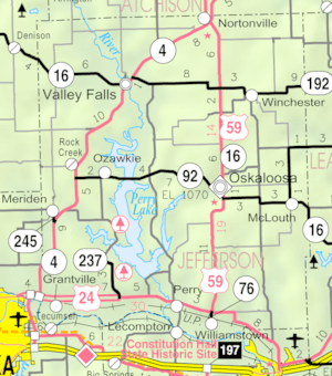
Here are the cities, small towns, and communities in Jefferson County:
Cities
- McLouth
- Meriden
- Nortonville
- Oskaloosa (county seat)
- Ozawkie
- Perry
- Valley Falls
- Winchester
Unincorporated Communities
These are smaller places that are not officially cities. Some are called Census-Designated Places (CDP) by the U.S. Census Bureau.
Townships
Jefferson County is split into twelve townships. The populations of the cities are included in their township's total.
| Township | FIPS | Main City | Population | Population density /km2 (/sq mi) |
Land area km2 (sq mi) |
Water area km2 (sq mi) |
Water % | Geographic coordinates |
|---|---|---|---|---|---|---|---|---|
| Delaware | 17425 | Valley Falls | 2,034 | 9 (23) | 229 (88) | 0 (0) | 0.11% | 39°21′6″N 95°28′31″W / 39.35167°N 95.47528°W |
| Fairview | 22525 | Rural Ozawkie | 1,510 | 22 (56) | 70 (27) | 20 (8) | 22.20% | 39°10′49″N 95°26′50″W / 39.18028°N 95.44722°W |
| Jefferson | 35250 | Winchester | 1,240 | 8 (21) | 151 (58) | 0 (0) | 0.24% | 39°19′37″N 95°16′11″W / 39.32694°N 95.26972°W |
| Kaw | 36125 | Grantville | 1,409 | 16 (43) | 86 (33) | 2 (1) | 1.78% | 39°5′41″N 95°32′55″W / 39.09472°N 95.54861°W |
| Kentucky | 36575 | Perry | 1,576 | 17 (44) | 93 (36) | 14 (5) | 13.18% | 39°5′18″N 95°24′42″W / 39.08833°N 95.41167°W |
| Norton | 51475 | Nortonville | 955 | 9 (25) | 101 (39) | 0 (0) | 0.30% | 39°24′13″N 95°18′47″W / 39.40361°N 95.31306°W |
| Oskaloosa | 53400 | Oskaloosa | 2,142 | 14 (37) | 149 (58) | 0 (0) | 0.17% | 39°13′12″N 95°18′58″W / 39.22000°N 95.31611°W |
| Ozawkie | 53950 | Ozawkie | 1,408 | 15 (38) | 97 (37) | 14 (5) | 12.74% | 39°14′32″N 95°26′3″W / 39.24222°N 95.43417°W |
| Rock Creek | 60575 | Meriden | 2,718 | 19 (50) | 140 (54) | 1 (1) | 0.92% | 39°12′52″N 95°32′58″W / 39.21444°N 95.54944°W |
| Rural | 61700 | Williamstown | 804 | 10 (25) | 82 (32) | 1 (0) | 1.14% | 39°4′31″N 95°18′52″W / 39.07528°N 95.31444°W |
| Sarcoxie | 63100 | Rural Lawrence | 958 | 12 (31) | 80 (31) | 0 (0) | 0.45% | 39°5′13″N 95°14′50″W / 39.08694°N 95.24722°W |
| Union | 72150 | McLouth | 1,672 | 15 (39) | 111 (43) | 0 (0) | 0.30% | 39°12′41″N 95°12′26″W / 39.21139°N 95.20722°W |
| Sources: | ||||||||
Notable People
- Roger Barker (1903-1990), an American psychologist who studied how people act in their surroundings.
- John Curry (1897–1946), a famous painter.
- Mary Lowman (1842-1912), the first woman in Kansas to be elected mayor with an all-female city council.
- Charles Roberts (1936-), an American politician.
See also
 In Spanish: Condado de Jefferson (Kansas) para niños
 | Emma Amos |
 | Edward Mitchell Bannister |
 | Larry D. Alexander |
 | Ernie Barnes |


