Leavenworth County, Kansas facts for kids
Quick facts for kids
Leavenworth County
|
|
|---|---|

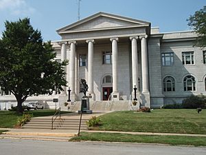
Leavenworth County Courthouse in Leavenworth
|
|

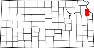
Location within the U.S. state of Kansas
|
|
 Kansas's location within the U.S. |
|
| Country | |
| State | |
| Founded | August 25, 1855 |
| Named for | Henry Leavenworth |
| Seat | Leavenworth |
| Largest city | Leavenworth |
| Area | |
| • Total | 469 sq mi (1,210 km2) |
| • Land | 463 sq mi (1,200 km2) |
| • Water | 6.1 sq mi (16 km2) 1.3%% |
| Population
(2020)
|
|
| • Total | 81,881 |
| • Estimate
(2021
|
82,184 |
| • Density | 176.8/sq mi (68.3/km2) |
| Time zone | UTC−6 (Central) |
| • Summer (DST) | UTC−5 (CDT) |
| Congressional district | 2nd |
Leavenworth County is a special area called a county in the state of Kansas. It's part of the bigger Kansas City metropolitan area, which is a large group of cities and towns. The main city and county seat is Leavenworth.
In 2020, about 81,881 people lived here. The county got its name from Henry Leavenworth. He was a general who started Fort Leavenworth.
Contents
A Look Back: Leavenworth County's Story
Early Days
For thousands of years, the Great Plains of North America were home to nomadic Native American tribes. They moved around to hunt and gather food.
From the 1500s to the 1700s, France said they owned big parts of North America. But in 1762, after a war, France secretly gave this land to Spain. This was part of a deal called the Treaty of Fontainebleau.
The 1800s
In 1802, Spain gave most of the land back to France. Then, in 1803, the United States bought a huge amount of land from France. This was called the Louisiana Purchase. It included most of what is now Kansas.
In 1854, the Kansas Territory was set up. Later, in 1861, Kansas became the 34th state in the U.S. Leavenworth County was officially created in 1855. It was one of the first 33 counties formed by the new government. Like its main city, it was named after Henry Leavenworth. He was an officer who fought in the War of 1812.
Leavenworth County was also the first place in Kansas to have a Kansas State University extension agent. This person helps local communities with education and resources.
Where is Leavenworth County?
Leavenworth County covers about 469 square miles. Most of this is land (463 square miles), and a small part is water (6.1 square miles). It's one of the smaller counties in Kansas.
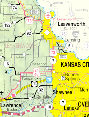
The county's rivers and streams flow into the Kansas River to the south. It also has a port city on the Missouri River to the east.
Nearby Places
Leavenworth County shares borders with these other counties:
- Platte County, Missouri (north)
- Wyandotte County (east)
- Johnson County (southeast)
- Douglas County (southwest)
- Jefferson County (west)
- Atchison County (northwest)
Who Lives Here?

Leavenworth County is part of the Kansas City Metropolitan Area. This means it's connected to a large urban area.
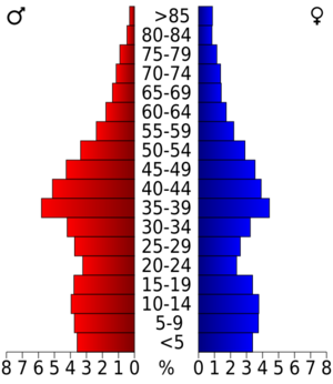
In 2000, there were 68,691 people living in the county. The population density was about 148 people per square mile. This tells us how many people live in a certain area.
Most people in the county were White (84.2%). About 10.4% were Black or African American. Other groups included Native American, Asian, and Pacific Islander people. About 3.8% of the population was Hispanic or Latino.
There were 23,071 households. A household is a group of people living together. About 38.9% of these households had children under 18. Many households were married couples living together.
The average age in the county was 36 years old. About 26.7% of the people were under 18. About 9.8% were 65 or older.
The median income for a household was $48,114. This is the middle income level for all households. About 6.7% of the people lived below the poverty line. This means they had very low incomes.
Learning in Leavenworth County
Colleges and Universities
Here are some places where you can go for higher education:
- United States Army Command and General Staff College
- University of Saint Mary
- Leavenworth Normal School (This school is now closed)
School Districts
These are the different school districts in the county:
- Basehor–Linwood USD 458
- Bonner Springs USD 204
- Easton USD 449
- Fort Leavenworth USD 207
- Jefferson County North USD 339
- Kansas City USD
- Lansing USD 469
- Lawrence USD 497
- Leavenworth USD 453
- McLouth USD 342
- Tonganoxie USD 464
Towns and Neighborhoods
Leavenworth County has many different communities. These include cities, smaller unincorporated communities, and even places that used to be towns but aren't anymore.
Cities
Some cities might spread into a neighboring county.
- Basehor
- Bonner Springs‡
- De Soto‡
- Easton
- Lansing
- Leavenworth (This is the county seat!)
- Linwood
- Tonganoxie
Small Towns and Areas
These are communities that are not officially incorporated as cities:
Places That Used To Be
- Delaware City (This is a ghost town now!)
Townships
Leavenworth County is divided into ten smaller areas called townships. The cities of Lansing and Leavenworth are separate and not included in these township numbers. The table below shows information about each township.
| Township | FIPS | Population center |
Population | Population density /km2 (/sq mi) |
Land area km2 (sq mi) |
Water area km2 (sq mi) |
Water % | Geographic coordinates |
|---|---|---|---|---|---|---|---|---|
| Alexandria | 01100 | 859 | 7 (18) | 123 (48) | 1 (0) | 0.62% | 39°16′8″N 95°7′33″W / 39.26889°N 95.12583°W | |
| Delaware | 17450 | 1,361 | 22 (57) | 62 (24) | 3 (1) | 4.19% | 39°14′50″N 94°52′40″W / 39.24722°N 94.87778°W | |
| Easton | 19625 | 1,245 | 11 (30) | 109 (42) | 0 (0) | 0.11% | 39°21′57″N 95°7′27″W / 39.36583°N 95.12417°W | |
| Fairmount | 22325 | Basehor | 6,266 | 61 (159) | 102 (39) | 0 (0) | 0.39% | 39°8′4″N 94°56′26″W / 39.13444°N 94.94056°W |
| High Prairie | 32125 | 1,768 | 14 (37) | 124 (48) | 0 (0) | 0.27% | 39°15′30″N 95°0′34″W / 39.25833°N 95.00944°W | |
| Kickapoo | 36700 | 1,760 | 15 (40) | 114 (44) | 3 (1) | 2.39% | 39°20′45″N 94°59′29″W / 39.34583°N 94.99139°W | |
| Reno | 58950 | 1,143 | 10 (27) | 111 (43) | 2 (1) | 1.56% | 39°1′8″N 95°8′8″W / 39.01889°N 95.13556°W | |
| Sherman | 65000 | 2,367 | 22 (57) | 108 (42) | 3 (1) | 2.44% | 39°0′59″N 95°0′27″W / 39.01639°N 95.00750°W | |
| Stranger | 68500 | 2,451 | 19 (50) | 127 (49) | 0 (0) | 0.17% | 39°8′16″N 95°2′2″W / 39.13778°N 95.03389°W | |
| Tonganoxie | 70825 | Tonganoxie (part) | 4,852 | 35 (91) | 137 (53) | 1 (0) | 0.66% | 39°7′0″N 95°6′35″W / 39.11667°N 95.10972°W |
| Sources: | ||||||||
Famous Faces from Leavenworth County
- Sean Malto, a professional skateboarder
- Wayne Simien, a professional basketball player
See also
 In Spanish: Condado de Leavenworth para niños
 | Precious Adams |
 | Lauren Anderson |
 | Janet Collins |


