
Johnson County, Kansas facts for kids
Quick facts for kids
Johnson County
|
|
|---|---|

Former Johnson County Courthouse in Olathe (2009). It opened in 1952, closed in 2020, then demolished in 2021 after a new courthouse was finished.
|
|

Location within the U.S. state of Kansas
|
|
 Kansas's location within the U.S. |
|
| Country | |
| State | |
| Founded | August 25, 1855 |
| Named for | Thomas Johnson |
| Seat | Olathe |
| Largest city | Overland Park |
| Area | |
| • Total | 480 sq mi (1,200 km2) |
| • Land | 473 sq mi (1,230 km2) |
| • Water | 6.5 sq mi (17 km2) 1.4% |
| Population
(2020)
|
|
| • Total | 609,863 |
| • Estimate
(2021)
|
613,219 |
| • Density | 1,289.4/sq mi (497.8/km2) |
| Time zone | UTC−6 (Central) |
| • Summer (DST) | UTC−5 (CDT) |
| Congressional district | 3rd |
Johnson County is a county in the state of Kansas. It is located right next to the border of Missouri. The main city and government center of the county is Olathe.
In 2020, Johnson County had a population of 609,863 people. This makes it the most populated county in all of Kansas! The county was named after Thomas Johnson. He was a Methodist missionary and one of the first people to settle in the state.
Johnson County is mostly made up of suburban areas. Many of its cities are suburbs of Kansas City, Missouri. One of the biggest cities in the county is Overland Park. It is also the second largest city in the wider Kansas City Metropolitan Area.
Contents
History of Johnson County
Long ago, this area was part of the land belonging to the Osage people. They lived in a large territory that stretched all the way to what is now Saint Louis, Missouri. Later, the United States government set aside much of this land as a special territory for the Shawnee people. They were moved here from their homes in the eastern parts of the country.
Famous trails like the Santa Fe Trail and the Oregon–California Trail passed through Johnson County. These trails were important routes for travelers heading west. Johnson County was created in 1855. It was one of the first counties in the new Kansas Territory. It was named after Thomas Johnson, who supported slavery.
During a time called "Bleeding Kansas," Johnson County saw many fights. These battles were between people who wanted to end slavery (abolitionists) and those who supported it. This happened before people in the territory voted on whether slavery would be allowed. In 1862, during the American Civil War, a group of Confederate fighters from Missouri attacked Olathe and Spring Hill. They caused a lot of damage and killed several people.
For a long time, Johnson County was mostly rural, meaning it had many farms and open spaces. But in the early 1900s, new neighborhoods started to be built. This happened especially in the northeastern part of the county, close to Kansas City, Missouri. A developer named J. C. Nichols helped this growth in 1914. He built the Mission Hills Country Club to attract wealthy people from Missouri to Kansas.
After World War II, the county grew very quickly. Many soldiers came home and needed places to live. New highways made it easier for people to drive from the suburbs to their jobs. Also, a big court case called Brown v. Board of Education happened in 1954. This ruling said that separating public schools by race was against the law. Because of this, many white families moved from Kansas City, Missouri, to Johnson County. They were looking for new homes and what they thought were better public schools. From the mid-1980s, Johnson County kept growing fast. It added about 100,000 new residents every ten years between 1990 and 2010.
The old Johnson County Courthouse, built in 1952, closed in 2020 and was torn down in 2021. A new, seven-story courthouse opened in 2021 after more than two years of building. This is the fourth courthouse the county has had.
Geography of Johnson County

Johnson County covers about 480 square miles (1,243 square kilometers). Most of this area, about 473 square miles (1,225 square kilometers), is land. The rest, about 6.5 square miles (17 square kilometers), is water.
Land and Water
The county's natural land is gently rolling, with hills and valleys. The Kansas River forms part of the county's northwest border. The land generally gets higher as you go from north to south, away from the Kansas and Missouri rivers.
Johnson County gets a lot of rain because it is in northeastern Kansas. Many small streams flow through the county. These include Kill Creek, Mill Creek, Turkey Creek, Indian Creek, Brush Creek, Tomahawk Creek, the Blue River, Bull Creek, and Little Bull Creek. All these streams eventually flow into the Missouri River.
Plants and Animals
Johnson County is mostly made up of open prairie grasslands. However, there are also areas with forests and trees along the streams and rivers.
Neighboring Counties
- Wyandotte County (north)
- Jackson County, Missouri (east)
- Cass County, Missouri (southeast)
- Miami County (south)
- Franklin County (southwest)
- Douglas County (west)
- Leavenworth County (northwest)
People of Johnson County
| Historical population | |||
|---|---|---|---|
| Census | Pop. | %± | |
| 1860 | 4,364 | — | |
| 1870 | 13,684 | 213.6% | |
| 1880 | 16,853 | 23.2% | |
| 1890 | 17,385 | 3.2% | |
| 1900 | 18,104 | 4.1% | |
| 1910 | 18,288 | 1.0% | |
| 1920 | 18,314 | 0.1% | |
| 1930 | 21,179 | 15.6% | |
| 1940 | 33,327 | 57.4% | |
| 1950 | 62,783 | 88.4% | |
| 1960 | 143,792 | 129.0% | |
| 1970 | 220,073 | 53.0% | |
| 1980 | 270,269 | 22.8% | |
| 1990 | 357,048 | 32.1% | |
| 2000 | 451,086 | 26.3% | |
| 2010 | 544,179 | 20.6% | |
| 2020 | 609,863 | 12.1% | |
| 2023 (est.) | 622,237 | 14.3% | |
| U.S. Decennial Census 1790-1960 1900-1990 1990-2000 2010-2020 |
|||
Johnson County is part of the Kansas City metropolitan area. It has the highest average household income and highest income per person in Kansas. In 2010, Money magazine listed Overland Park as the 7th best city to live in the United States. Shawnee was ranked 17th, and Olathe was ranked 11th in 2008.
Population in 2010
In 2010, there were 544,179 people living in Johnson County. About 86% of the people were White, 4.3% were Black or African American, and 4.2% were Asian. About 7.2% of the population identified as Hispanic or Latino.
About 34.6% of households had children under 18 living with them. The average household had 2.51 people, and the average family had 3.05 people. The median age in the county was 36.4 years old. This means half the people were younger than 36.4, and half were older.
The average income for a household in the county was $73,733. For families, it was $90,380. About 5.5% of the population lived below the poverty line.
Law Enforcement
| Johnson County Sheriff's Office | |
|---|---|

Patch of Johnson County Sheriff's Office
|
|
| Abbreviation | JCSO |
| Agency overview | |
| Formed | 1861 |
| Jurisdictional structure | |
| Operations jurisdiction | Johnson, Kansas, USA |
| Operational structure | |
| Headquarters | 27747 West 159th Street, New Century, KS 66031 |
| Agency executive |
|
The Johnson County Sheriff's Office is in charge of the jails in Olathe and New Century. They also patrol the areas of Johnson County that are not part of any city. This includes the cities of Edgerton and DeSoto.
In 2019, the county announced that it was creating a new team to fight crime. This team would work with the neighboring counties of Miami and Franklin.
Education in Johnson County
.jpg)
Most adults aged 25 and over in Johnson County have finished high school (95.6%). More than half (51.1%) have a bachelor's degree or higher. About 17.9% have a graduate or professional degree.
The Johnson County Library has 13 different locations.
School Districts
- Blue Valley USD 229
- Spring Hill USD 230
- Gardner-Edgerton USD 231
- De Soto USD 232
- Olathe USD 233
- Shawnee Mission USD 512
Colleges and Universities
- Johnson County Community College
- University of Kansas Edwards Campus
- Kansas State University, Olathe Campus
- Kansas Christian College (Overland Park)
- MidAmerica Nazarene University
- Baker University, Overland Park Campus
- Ottawa University, Overland Park Campus
- Park University, Lenexa Campus
Transportation in Johnson County
Johnson County has a very organized road system. Roads are typically placed every mile, forming a grid. This grid has helped the county grow quickly and makes it easy to get around. Interstate 435 runs through much of the county. It acts like a dividing line for development. The northern part of the county is older, while the southern part is growing the fastest with many new homes.
The street numbers in Johnson County usually start at 47th Street. This is a continuation of the street system from nearby Kansas City, Missouri. The numbered streets go all the way up to 215th Street.
Another main highway is Interstate 35. It cuts diagonally through the county, passing through Olathe and Gardner. This highway goes all the way north to Duluth, Minnesota and south to the US–Mexico border. U.S. 69 also serves Johnson County. Much of U.S. 69 in the county is a freeway. It heads south to Fort Scott and other parts of southeast Kansas.
Main Highways
 I-35 Runs from the southwest corner (with Franklin County) northeast through Edgerton, Gardner, Olathe, Lenexa, Overland Park, and Merriam to the northeast corner (with downtown Kansas City).
 I-435 Runs along the northern border (with Wyandotte County) south through Shawnee and Lenexa to K-10. Then it goes east through Overland Park and Leawood to the Missouri border.
 I-635 Starts in Johnson County at I-35 and quickly enters Wyandotte County/Kansas City, KS.
 US-50 Runs from the southwest corner (with Franklin County) northeast through Edgerton, Gardner, Olathe, Lenexa, Overland Park, and Merriam to the northeast corner (with downtown Kansas City).
 US-56 Runs along the southwest border (with Douglas County) east through Edgerton and Gardner to I-35.
 US-69 Runs from the southeast border (with Miami County) north through Stilwell and Overland Park past I-435 to I-35.
 US-169 Runs along the southern border (with Miami County). It joins with I-35 in Olathe.
 K-7 Runs from the southern border (with Miami County) north through Spring Hill, Olathe, Lenexa, and Shawnee to Wyandotte County.
 K-10 Runs along the western border (with Douglas County) east through De Soto, Lenexa, and Olathe to I-435.
Airports
Johnson County has three airports for general aviation (smaller planes, not major airlines):
- Johnson County Executive Airport
- New Century AirCenter
- Hillside Airport
The closest airport with flights from major airlines is Kansas City International Airport. It is located in Platte County, Missouri.
Public Transportation
Johnson County Transit is the company that provides public transportation in the county.
Communities in Johnson County

Here is a list of cities and other communities in Johnson County.
Cities
‡ means a community has parts in another county.
Unincorporated Communities
These are areas that are not part of any city.
Townships
Johnson County was first divided into nine areas called townships. Two of these no longer exist because their land was taken over by cities. The cities are separate and not counted in the township populations.
| Township | Population | Population density /km2 (/sq mi) |
Land area km2 (sq mi) |
Water area km2 (sq mi) |
Water % | Geographic coordinates | ||
|---|---|---|---|---|---|---|---|---|
| Aubry | 5,440 | 43 (112) | 126 (49) | 0 (0) | 0.31% | 38°46′48″N 94°41′4″W / 38.78000°N 94.68444°W | ||
| Gardner | 2,143 | 21 (55) | 102 (39) | 1 (0) | 0.53% | 38°49′7″N 94°54′31″W / 38.81861°N 94.90861°W | ||
| Lexington | 3,712 | 10 (25) | 135 (52) | 2 (1) | 1.79% | 38°55′0″N 95°0′13″W / 38.91667°N 95.00361°W | ||
| McCamish | 878 | 8 (20) | 112 (43) | 0 (0) | 0.34% | 38°47′22″N 94°59′48″W / 38.78944°N 94.99667°W | ||
| Mission (no longer exists) | 0 | 0 (0) | 0 (0) | 0 (0) | 0% | 39°0′7″N 94°38′11″W / 39.00194°N 94.63639°W | ||
| Monticello (no longer exists) | 0 | 0 (0) | 0 (0) | 0 (0) | 0% | 39°1′59″N 94°47′57″W / 39.03306°N 94.79917°W | ||
| Olathe | 1,187 | 27 (70) | 44 (17) | 0 (0) | 0.04% | 38°54′21″N 94°49′18″W / 38.90583°N 94.82167°W | ||
| Oxford | 2,020 | 121 (313) | 17 (6) | 0 (0) | 1.54% | 38°49′58″N 94°40′54″W / 38.83278°N 94.68167°W | ||
| Shawnee (no longer exists) | 0 | 0 (0) | 0 (0) | 0 (0) | 0% | 39°1′51″N 94°47′47″W / 39.03083°N 94.79639°W | ||
| Spring Hill | 2,059 | 29 (76) | 70 (27) | 0 (0) | 0.30% | 38°46′35″N 94°48′55″W / 38.77639°N 94.81528°W | ||
| Sources: Kansas Historical Society, Johnson County. Retrieved from the website on June 11, 2021. | ||||||||
Johnson County in Popular Culture
- The movie The Day After, which is about the end of the world, was partly filmed in De Soto.
- The TV show Switched at Birth is set in Mission Hills.
- The Netflix show Dirty Money, in an episode called "Payday," shows many aerial views of Leawood.
- The independent film All Creatures Here Below is partly set in De Soto and was filmed in Kansas City.
Images for kids
-
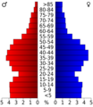
Population pyramid based on 2000 census age data

See also
 In Spanish: Condado de Johnson (Kansas) para niños
