
Miami County, Kansas facts for kids
Quick facts for kids
Miami County
|
|
|---|---|

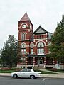
Miami County Courthouse in Paola (2009)
|
|

Location within the U.S. state of Kansas
|
|
 Kansas's location within the U.S. |
|
| Country | |
| State | |
| Founded | August 25, 1855 |
| Named for | Miami tribe |
| Seat | Paola |
| Largest city | Spring Hill |
| Area | |
| • Total | 590 sq mi (1,500 km2) |
| • Land | 576 sq mi (1,490 km2) |
| • Water | 15 sq mi (40 km2) 2.5%% |
| Population
(2020)
|
|
| • Total | 34,191 |
| • Estimate
(2021)
|
34,593 |
| • Density | 59.4/sq mi (22.9/km2) |
| Time zone | UTC−6 (Central) |
| • Summer (DST) | UTC−5 (CDT) |
| Congressional district | 3rd |
Miami County is a place in Kansas located in the east-central part of the state. It's also part of the larger Kansas City metropolitan area. The main city and county seat is Paola, which is also the biggest city.
In 2020, about 34,191 people lived in Miami County. The county got its name from the Miami tribe, a Native American group.
Contents
A Look Back: Miami County's History
First People: Native American Tribes
The first people to settle in this area were Native American tribes. This happened mostly between the 1820s and 1840s. These tribes were moved here from places like Ohio, Illinois, and Indiana. This area was set aside as part of the Indian Territory.
Some of the tribes that lived here included the Miami, Shawnee, Pottawatomie, Piankeshaw, Kaskaskia, Wea, and Peoria. These last few tribes were part of a group called the Confederated Tribes. The original Miami tribe's land was huge, about 500,000 acres (2,000 km2).
Early white settlers came mostly as missionaries to help the tribes. Over time, more settlers arrived and built homes on the Miami land. By 1854, the U.S. Government bought most of this land from the Miami tribe, leaving them with about 72,000 acres (290 km2).
Two important members of the Confederated Tribes were Christmas Dagnette and Baptiste Peoria. Christmas Dagnette was born in 1800. He was the nephew of a Wea chief and had a good education. He spoke many Native American languages, plus English, French, and Spanish. By age sixteen, he was an interpreter for the U.S. Government. He became a chief for several years before he passed away in 1848.
Baptiste Peoria was also born around 1800. He didn't have a formal education like Dagnette. But he learned the languages of the Shawnee, Delaware, Pottawatomie, and other tribes. He also spoke English and French. Baptiste Peoria was part French and part Native American. Like Dagnette, he worked as an interpreter and was a chief.
Baptiste Peoria was a respected member of the Paola Town Company. He helped a lot in starting and growing the city of Paola in the early and mid-1860s. In 1868, he moved with his tribe to what is now Oklahoma. They were moved again to a new Indian territory. He died there in 1878. Some Native Americans stayed in Miami County and became U.S. citizens.
The Trail of Death
A sad and important path called the Trail of Death is recognized in Indiana, Illinois, Missouri, and Kansas. Signs in these states show where this historic path goes. In Miami County, the trail is about 27 miles long. It follows local roads, starting in the north and going south through different streets and highways.
In 1836, a treaty forced Native American tribes in the Eastern U.S. to move west. But Pottawatomie Chief Menominee and his tribe refused to leave their land. In the fall of 1838, the Pottawatomie were forced to leave their homes. They went on a very difficult two-month journey. During this trip, 42 of the 859 Native Americans died. Most of them were children and older people. They died from sickness and the stress of the journey. They were buried along the way, and this route became known as the Trail of Death.
When they reached Kansas, some Pottawatomie lived for about ten years in Linn County. Other Pottawatomie tribes were moved to different parts of eastern Kansas.
The trail begins in Rochester, Indiana, and goes through Illinois and Missouri before ending in eastern Kansas. A man named Jesse C. Douglas wrote down the route. He traveled with the group on their march.
Every five years since 1988, a group of Pottawatomie Indians and historians has retraced the 660-mile trail. This is called the Trail of Death Commemorative Caravan. Today, visitors can see items from the Pottawatomie Tribe at the Miami County Historical Museum in Paola. These displays include a diary of their difficult trip.
Before the Civil War
When Kansas Territory was formed in 1854, an important law called the Missouri Compromise was basically canceled. Miami County was next to Missouri, which was a slave state. Because of this, Miami County and the areas around it became a place of fighting. This fighting was between people who wanted to end slavery (abolitionists) and those who supported slavery, often called "border ruffians" from Missouri.
These fights and battles happened mostly from 1854 to 1858. They became known as the border wars, and Kansas was called "Bleeding Kansas". Kansas was not yet a state. It was a battle to decide if it would become a free state (no slavery) or a slave state. Many abolitionists moved to the area from other states. They wanted to make sure Kansas joined the U.S. as a free state.
The most famous abolitionist in the county was John Brown. He moved to Osawatomie, making it his base for his anti-slavery group. Because of this, Osawatomie and the nearby areas became the center for many battles and violent acts during this time. Near Osawatomie, you can still find historic sites related to John Brown, like his famous lookout from the Civil War.
How Miami County Got Its Name
Miami County was first created in 1855 and was called Lykins County. It was named after Dr. David Lykins. Dr. Lykins was a missionary who worked with Native American tribes in the area. He built a school for them in what is now rural Miami County. He also served in the local government and supported slavery.
By January 1861, the anti-slavery groups had become stronger. Kansas joined the United States as a free state. Because Dr. Lykins supported slavery, the county's name was changed. On June 3, 1861, Lykins County became Miami County. The new name honored the main Native American tribe that had settled in the area, the Miami.
Natural Gas Discovery
In 1882, a large amount of natural gas was found in rural Miami County. It was about 7 miles (11 km) east of Paola. By 1886, a pipeline was built to bring the gas to Paola's town square. The gas was used to light the lamps there. By 1887, Paola's street lamps were lit with natural gas.
More natural gas fields were found throughout Miami County by 1887. For a while, the area around Paola was known as a "gas belt." In the summer of 1887, a "Natural Gas Jubilee" was held. It was a big celebration where people came to see and admire the use of natural gas.
Geography and Nature
Miami County covers a total area of 590 square miles (1,500 km2). Most of this is land, about 576 square miles (1,490 km2). The rest, about 15 square miles (39 km2), is water.
Lakes to Explore
Miami County has several lakes where you can enjoy nature and outdoor activities.
- Hillsdale Lake – This is the biggest lake in Miami County. It offers many different activities. You can go camping, fishing, swimming, boating, hunting, and hiking. There are also 32 miles (51 km) of marked trails for horseback riding on the east side of the lake. There's even a special area for flying model airplanes.
- Louisburg Middle Creek Lake – This lake is about 7 miles (11 km) south of Louisburg, Kansas. It's an important source of water for the city of Louisburg. The lake is also great for fishing and camping. Fishing boats are allowed, but you can't swim or do other water sports here. The Kansas Department of Wildlife and Parks manages this lake. You can find many types of fish here, like Bluegill, Channel Catfish, Bass, and Crappie. The lake and campsites are open to everyone for free. It's a peaceful place to visit.
Other lakes in Miami County, each with its own rules and activities, include:
- Miola Lake
- Miami County State Lake
- Osawatomie Lake
- Paola Lake
- Hunters Lake
- Wagstaff Lake
Nearby Counties
Miami County shares its borders with several other counties:
- Johnson County (north)
- Cass County, Missouri (east)
- Bates County, Missouri (southeast)
- Linn County (south)
- Anderson County (southwest)
- Franklin County (west)
- Douglas County (northwest)
People and Population

Miami County is part of the larger Kansas City metropolitan area.
In 2000, there were about 28,351 people living in the county. About 96% of the people were White, and about 1.5% were Black or African American. About 1.6% of the population was Hispanic or Latino.
The average age of people in Miami County was 37 years old. About 28% of the population was under 18 years old.
The average income for a household in the county was about $46,665. For a family, the average income was about $55,830. About 5.5% of all people in the county lived below the poverty line.
Important Places and Landmarks
Miami County has many important landmarks and buildings with historical meaning. You can find historic bridges and buildings like the Creamery Bridge. There's also history related to John Brown and the Civil War in and near Osawatomie. Near Louisburg, you can visit a famous musical landmark and a cider mill. In Paola, there's a library built to honor a wine maker. The Poor Farm Cemetery is another historic site. Many people buried there once worked on the county's Poor Farm.
Community Life
Miami County is located just a short drive south of Kansas City. This means it offers people a mix of city and country living. Miami County and its cities like Paola, Louisburg, Spring Hill, Osawatomie, and Fontana offer many activities and hobbies.
You can enjoy golf, hiking, camping, fishing, hunting, horseback riding, and water sports. There are also community festivals and events throughout the year. You can visit historical places and museums to learn about the county's past. During the summer, each community has a farmer's market. Here, you can find locally grown food and goods.
Miami County Farm Tour
Every spring, many farms and farm businesses in Miami County take part in the Miami County Farm Tour. Everyone is invited to visit these farms with their families for free. It's a self-guided driving tour. The goal is to see and learn about how the farms work, what they grow, and what animals they have. This farm tour has become a popular yearly event for both visitors and people who live in Miami County.
Farming in Miami County
Farming is a big part of Miami County. In 2007, there were 1,538 farms in the county. The average farm size was about 200 acres (0.81 km2). Hay and other types of forage (food for animals) are the top crops, grown on over 54,000 acres (220 km2). More than 40,000 acres (160 km2) are used to grow soybeans. Corn is planted on over 20,500 acres (83 km2).
When it comes to livestock, cattle and calves are the most common, with over 43,000 of them. Horses and chickens (called layers) are next, with over 3,400 horses and 2,100 chickens.
A famous dairy cow once lived in Miami County. This Holstein cow, named Enns Banner Olivia, was the World Supreme Champion in 1990. She came to a farm in Miami County when she was three years old.
Farmers in Miami County can use the Fontana Co-Op. This is a place where they can store their harvested crops until they are ready to sell them. There are two locations for farmers to use.
Education in Miami County
A long time ago, Miami County had more than 100 schools. Most of these old school buildings are gone now or have been empty for many years. However, the Rock Creek School is still standing. It's a one-room schoolhouse built in 1910. It was used as a school until 1966. People living nearby bought the red brick schoolhouse for just $1. Today, it's still used as a community hall for meetings, dinners, and other events.
In 1878, a "Normal School" was started in Paola by Professor John Wherrell. A Normal School was a place to train teachers. This was one of only five such schools in Kansas at the time. It was very successful for six years. Some famous students who went there include U.S. Senator Chester I. Long and George Washington Carver, who is known as the "father of peanuts."
Local School Districts
Here are the unified school districts that serve Miami County:
- Osawatomie USD 367
- Paola USD 368
- Louisburg USD 416
- Spring Hill USD 230
- Wellsville USD 289
Communities in Miami County

Miami County has several cities, small towns, and townships.
Cities
Some cities might have parts in a neighboring county.
- Fontana
- Louisburg
- Osawatomie
- Paola (This is the county seat)
- Spring Hill‡
Unincorporated Communities
These are smaller communities that are not officially cities. Some are also called Census-Designated Places (CDP).
Townships
Miami County is divided into thirteen areas called townships. The cities of Louisburg, Osawatomie, Paola, and Spring Hill are separate from these townships for census purposes.
| Township | Population | Land area km2 (sq mi) |
Water area km2 (sq mi) |
Water % |
|---|---|---|---|---|
| Marysville | 2,575 | 131 (50) | 12 (5) | 8.28% |
| Miami | 506 | 126 (48) | 1 (0) | 0.53% |
| Middle Creek | 1,649 | 151 (58) | 1 (1) | 0.89% |
| Mound | 705 | 83 (32) | 0 (0) | 0.06% |
| Osage | 649 | 106 (41) | 0 (0) | 0.46% |
| Osawatomie | 794 | 90 (35) | 0 (0) | 0.12% |
| Paola | 1,100 | 71 (27) | 0 (0) | 0.65% |
| Richland | 1,758 | 166 (64) | 16 (6) | 8.89% |
| Stanton | 925 | 103 (40) | 0 (0) | 0.37% |
| Sugar Creek | 449 | 104 (40) | 1 (0) | 0.63% |
| Ten Mile | 1,259 | 121 (47) | 1 (0) | 0.51% |
| Valley | 1,478 | 93 (36) | 0 (0) | 0.37% |
| Wea | 1,836 | 117 (45) | 1 (0) | 0.43% |
Images for kids
-
Miami County Courthouse in Paola (2009)
See also
 In Spanish: Condado de Miami (Kansas) para niños
