Franklin County, Kansas facts for kids
Quick facts for kids
Franklin County
|
|
|---|---|

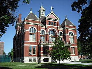
Franklin County Courthouse in Ottawa (2009)
|
|

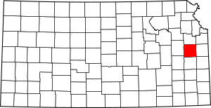
Location within the U.S. state of Kansas
|
|
 Kansas's location within the U.S. |
|
| Country | |
| State | |
| Founded | August 25, 1855 |
| Named for | Benjamin Franklin |
| Seat | Ottawa |
| Largest city | Ottawa |
| Area | |
| • Total | 577 sq mi (1,490 km2) |
| • Land | 572 sq mi (1,480 km2) |
| • Water | 5.4 sq mi (14 km2) 0.9%% |
| Population
(2020)
|
|
| • Total | 25,996 |
| • Density | 45.4/sq mi (17.5/km2) |
| Time zone | UTC−6 (Central) |
| • Summer (DST) | UTC−5 (CDT) |
| Congressional district | 3rd |
Franklin County is a county in the eastern part of Kansas. Its main city and county seat is Ottawa. In 2020, about 25,996 people lived here. The county is named after Benjamin Franklin, one of America's founding fathers. It used to be part of the Kansas City metropolitan area, but not anymore since 2013.
Contents
History of Franklin County
Early Days
For thousands of years, Native American tribes lived on the Great Plains. From the 1500s to the 1700s, France claimed much of North America. After a war in 1762, France secretly gave its land, called New France, to Spain.
The 1800s
In 1802, Spain gave most of this land back to France. Then, in 1803, the United States bought a huge area from France. This was called the Louisiana Purchase. It included most of what is now Kansas. The U.S. paid about 2.83 cents per acre!
Later, in 1808, the land was given to the Osage Nation tribe. But they gave it back to the government in 1825. Before 1867, other treaties were made with different Native American tribes. These tribes, like the Ottawa and Sac and Fox, were moved from their homes. Parts of what became Franklin County were set aside for them.
In 1854, the Kansas Territory was created. Then, in 1855, Franklin County was officially formed. It was one of the first 33 counties in the Kansas Territory. As mentioned, it was named after Benjamin Franklin. In 1861, Kansas became the 34th state in the U.S.
Geography of Franklin County
Franklin County covers about 577 square miles. Most of this is land (572 square miles). A small part, about 5.4 square miles, is water.
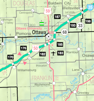
Main Roads
- Interstate 35
- U.S. Route 50
- U.S. Route 59
- K-33
- K-68
Neighboring Counties
- Douglas County (north)
- Johnson County (northeast)
- Miami County (east)
- Linn County (southeast)
- Anderson County (south)
- Coffey County (southwest)
- Osage County (west)
People of Franklin County
| Historical population | |||
|---|---|---|---|
| Census | Pop. | %± | |
| 1860 | 3,030 | — | |
| 1870 | 10,385 | 242.7% | |
| 1880 | 16,797 | 61.7% | |
| 1890 | 20,279 | 20.7% | |
| 1900 | 21,354 | 5.3% | |
| 1910 | 20,884 | −2.2% | |
| 1920 | 21,946 | 5.1% | |
| 1930 | 22,024 | 0.4% | |
| 1940 | 20,889 | −5.2% | |
| 1950 | 19,928 | −4.6% | |
| 1960 | 19,548 | −1.9% | |
| 1970 | 20,007 | 2.3% | |
| 1980 | 22,062 | 10.3% | |
| 1990 | 21,994 | −0.3% | |
| 2000 | 24,784 | 12.7% | |
| 2010 | 25,992 | 4.9% | |
| 2020 | 25,996 | 0.0% | |
| 2023 (est.) | 26,125 | 0.5% | |
| U.S. Decennial Census 1790–1960 1900–1990 1990–2000 2010-2020 |
|||
In 2000, there were 24,784 people living in Franklin County. Most people (about 95%) were White. There were also smaller groups of Black, Native American, and Asian people. About 2.6% of the population was Hispanic or Latino.
The county had 9,452 households. About 34.7% of these households had children under 18. The average age of people in the county was 36 years old.
Education in Franklin County
School Districts
- West Franklin USD 287
- Central Heights USD 288
- Wellsville USD 289
- Ottawa USD 290
Colleges and Universities
- Ottawa University, in Ottawa
- Neosho County Community College (a branch campus), in Ottawa
Communities in Franklin County
Franklin County has several cities and smaller communities.
Cities
- Lane
- Ottawa (the county seat)
- Pomona
- Princeton
- Rantoul
- Richmond
- Wellsville
- Williamsburg
Unincorporated Places
These are smaller communities that are not officially cities. Some are called Census-Designated Places (CDP) by the U.S. Census Bureau.
Ghost Towns
These are places where communities once existed but are now abandoned.
- Minneola
- Norwood
- Ohio City
- Pleasant Hill
- Shermansville
- Silkville
Townships
Franklin County is divided into sixteen areas called townships. The city of Ottawa is separate from these townships for government purposes.
Famous People from Franklin County
- Foster Dwight Coburn, who was the Secretary of Agriculture for Kansas.
- Steve Grogan, a former NFL quarterback who grew up in Ottawa.
- Chely Wright, a well-known singer.
- James Still (playwright), a writer who grew up in Pomona.
- Gary Hart, a Democratic U.S. Senator.
See also
 In Spanish: Condado de Franklin (Kansas) para niños
 | John T. Biggers |
 | Thomas Blackshear |
 | Mark Bradford |
 | Beverly Buchanan |


