
LeLoup, Kansas facts for kids
Quick facts for kids
LeLoup, Kansas
|
|
|---|---|

|
|

LeLoup, Kansas
Location in Kansas

LeLoup, Kansas
Location in the United States
|
|
| Country | United States |
| State | Kansas |
| County | Franklin |
| Founded | 1870 |
| Named for | Wolf |
| Elevation | 955 ft (291 m) |
| Time zone | UTC-6 (CST) |
| • Summer (DST) | UTC-5 (CDT) |
| Area code | 785 |
| FIPS code | 20-39300 |
| GNIS ID | 479371 |
LeLoup is a small, unincorporated community located in Franklin County, Kansas, in the United States. An unincorporated community means it's a place with homes and businesses but without its own local government. You can find LeLoup about 1.5 miles north of Interstate 35 on Tennessee Road. It is about 11 miles northeast of Ottawa and 7 miles southwest of Wellsville.
The History of LeLoup
LeLoup was first established in 1870. This happened after the Santa Fe Railroad built its train tracks through the area, which helped communities grow.
How LeLoup Got Its Name
The community was originally named Ferguson. It was named after Robert Ferguson, who owned the land where the town was planned.
The name changed to LeLoup because of a fun story! A traveler from France got off the train at Ferguson. He saw a coyote and thought it was a wolf. He started shouting "le loup!" which means "the wolf" in French. After this, the people living there decided to change the community's name to LeLoup.
LeLoup also had its own post office for many years. It opened in September 1870. The post office's name changed from Ferguson to LeLoup in 1879. It stayed open until 1954.
Gallery
-
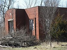
An old school in LeLoup (2008)

