
Douglas County, Kansas facts for kids
Quick facts for kids
Douglas County
|
||
|---|---|---|

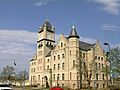
Douglas County Courthouse in Lawrence
|
||
|
||

Location within the U.S. state of Kansas
|
||
 Kansas's location within the U.S. |
||
| Country | ||
| State | ||
| Founded | August 25, 1855 | |
| Named for | Stephen Douglas | |
| Seat | Lawrence | |
| Largest city | Lawrence | |
| Area | ||
| • Total | 475 sq mi (1,230 km2) | |
| • Land | 456 sq mi (1,180 km2) | |
| • Water | 19 sq mi (50 km2) 4.0%% | |
| Population
(2020)
|
||
| • Total | 118,785 | |
| • Estimate
(2021)
|
119,363 |
|
| • Density | 260.5/sq mi (100.6/km2) | |
| Time zone | UTC−6 (Central) | |
| • Summer (DST) | UTC−5 (CDT) | |
| Area code | 785 | |
| Congressional districts | 1st, 2nd | |

Douglas County is a county located in the U.S. state of Kansas. Its main city and county seat is Lawrence. In 2020, about 118,785 people lived here. This makes it the fifth-largest county in Kansas by population. The county was named after Stephen Douglas. He was a U.S. Senator from Illinois. He believed that people in new territories should choose if they wanted slavery or not.
Contents
History
Early History of Kansas
For thousands of years, nomadic Native Americans lived on the Great Plains of North America. In the 16th to 18th centuries, France claimed much of North America. In 1762, France secretly gave New France to Spain. This was part of the Treaty of Fontainebleau.
In 1802, Spain returned most of this land to France. Then, in 1803, the United States bought most of the land that is now Kansas from France. This was part of the huge Louisiana Purchase. The U.S. paid about 2.83 cents per acre.
19th Century Events
In 1854, the Kansas Territory was set up. Later, in 1861, Kansas became the 34th U.S. state. Douglas County was officially created in 1855. It was opened for people to settle on May 15, 1854. The county was named after Stephen A. Douglas, a senator from Illinois.
Douglas County was at the center of a difficult time called Bleeding Kansas. Leaders in Lecompton, the capital of the territory, wanted Kansas to allow slavery. But leaders in Lawrence wanted Kansas to be a free state. These two groups strongly disliked each other. This led to many conflicts and important events.
Some of these events included:
- The Lecompton Constitution: This was a plan to make Kansas a slave state.
- The Wakarusa War (1855): A small conflict between the two sides.
- The Sack of Lawrence (1856): Pro-slavery forces attacked Lawrence.
- The Battle of Black Jack (1856): A fight between anti-slavery and pro-slavery groups.
- The Lawrence Massacre (1863): A deadly attack on Lawrence during the American Civil War.
The first railroad in Douglas County was built in 1864. It was called the Kansas Pacific.
Geography

Douglas County covers about 475 square miles. About 456 square miles are land, and 19 square miles are water. This means about 4% of the county is water. It is the fifth-smallest county in Kansas by land area. The Kansas River forms much of its northern border. This river flows through Lawrence and helps make electricity at the Bowersock Dam.
Lakes
Neighboring Counties
- Jefferson County (north)
- Leavenworth County (northeast)
- Johnson County (east)
- Miami County (southeast)
- Franklin County (south)
- Osage County (southwest)
- Shawnee County (northwest)
Population Facts

| Historical population | |||
|---|---|---|---|
| Census | Pop. | %± | |
| 1860 | 8,637 | — | |
| 1870 | 20,592 | 138.4% | |
| 1880 | 21,700 | 5.4% | |
| 1890 | 23,961 | 10.4% | |
| 1900 | 25,096 | 4.7% | |
| 1910 | 24,724 | −1.5% | |
| 1920 | 23,998 | −2.9% | |
| 1930 | 25,143 | 4.8% | |
| 1940 | 25,171 | 0.1% | |
| 1950 | 34,086 | 35.4% | |
| 1960 | 43,720 | 28.3% | |
| 1970 | 57,932 | 32.5% | |
| 1980 | 67,640 | 16.8% | |
| 1990 | 81,798 | 20.9% | |
| 2000 | 99,962 | 22.2% | |
| 2010 | 110,826 | 10.9% | |
| 2020 | 118,785 | 7.2% | |
| 2023 (est.) | 120,553 | 8.8% | |
| U.S. Decennial Census 1790-1960 1900-1990 1990-2000 2010-2020 |
|||
Douglas County is part of the Lawrence, KS Metropolitan Statistical Area. It is also part of the larger Kansas City metropolitan area.
In 2000, there were about 99,962 people living in the county. The population density was about 219 people per square mile. Most people in the county were White (86.1%). Other groups included Black or African American (4.2%), Native American (2.6%), and Asian (3.1%). About 3.3% of the population was Hispanic or Latino.
The average age in the county was 27 years old. Many young people live here, with 26.4% of the population being between 18 and 24 years old. This is likely because of the universities in the area.
Education

Universities in Douglas County
- Baker University: This is the oldest university in Kansas. It is located in Baldwin City.
- Haskell Indian Nations University: This university is in Lawrence. It serves Native American students.
- University of Kansas (KU): The main campus of KU is in Lawrence.
School Districts
Douglas County has seven school districts. These districts serve different parts of the county.
- Lawrence USD 497: Serves Lawrence and areas around Clinton Lake.
- Baldwin City USD 348: Serves Baldwin City and most of southern Douglas County.
- Eudora USD 491: Serves Eudora and the northeast part of the county.
Some school districts also cover parts of neighboring counties:
- Perry-Lecompton USD 343: Serves Lecompton and northwest Douglas County.
- Shawnee Heights USD 450: Serves the far western part of the county, including Big Springs.
- Santa Fe Trail USD 434: An Osage County district that covers the far southwest part of Douglas County.
- Wellsville USD 289: Covers the very southeast part of Douglas County.
Parks and Recreation
Clinton Lake was finished in 1980. It's a great place for boating, fishing, and other water sports. Parks around the lake offer camping and trails for biking, hiking, and horseback riding.
Lone Star Lake is a smaller lake southwest of Lawrence. It's good for fishing, boating, and camping. Northeast of Baldwin City is Douglas State Fishing Lake. Here you can go hunting, fishing, and do some camping. Other parks include Black Jack Park, Broken Arrow Park in Lawrence, and Wells Overlook Park south of Lawrence.
Events
Douglas County hosts several fun events throughout the year.
- The Maple Leaf Festival happens in Baldwin City every third full weekend in October.
- Lecompton celebrates its Territorial Days every June.
- Lawrence has many parades, including for Christmas and St. Patrick's Day.
Transportation
Major Highways

 I-70 / Kansas Turnpike: This highway runs east to west, just north of Lawrence.
 US-59: This highway goes north to south through the middle of the county and Lawrence.
 US-40: This road generally follows the historic Oregon Trail as it heads west from Lawrence.
 US-56: This highway runs east to west in the southern part of the county. It goes through Baldwin City and is near the Santa Fe Trail.
 K-10: This highway starts near I-70 in Lecompton. It goes along the south and west edge of Lawrence, then east into Johnson County.
Other important highways include:
 US-24: This road is in Grant township and connects to Jefferson County.
 K-32: This highway starts near Lawrence and goes into Leavenworth County.
 K-33: This road is in the very southeast of Douglas County and leads into Franklin County.
County Highways
Douglas County also has many county highways. These roads help people travel in the rural areas of the county. None of these county highways are inside the city limits of Lawrence.
Communities

Douglas County has several cities, unincorporated communities, and even some places that used to be towns but are now gone.
Cities
- Baldwin City
- Eudora
- Lawrence (the county seat)
- Lecompton
Unincorporated Communities
These are smaller communities that are not officially cities.
Ghost Towns
These are places that were once communities but are no longer inhabited.
- Belvoir
- Franklin
- Lapeer
- Louisiana
- Media
- Prairie City
- Simmons Point Station
- Twin Mound
- Weaver
Townships
Douglas County is divided into nine areas called townships. The city of Lawrence is separate from these townships for census purposes.

Historic Townships
Originally, the county had only four townships. Over time, these were divided or renamed. For example, Lecompton township used to cover a larger area. Grant township was added from Jefferson County in 1874.
Notable People
- Isaac F. Hughes: He was a commissioner for Douglas County and also served on the City Council in Lawrence, Kansas.
Images for kids
-
Douglas County Courthouse in Lawrence
-

Douglas County Kansas logo
-
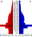
Population pyramid based on 2000 census age data
-
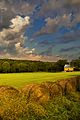
Scenic view of Rural Douglas County
-
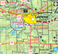
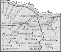
2005 map of Douglas County
-
Map of Douglas County, 1889, from History of Kansas.
See also
 In Spanish: Condado de Douglas (Kansas) para niños
