Mission Woods, Kansas facts for kids
Quick facts for kids
Mission Woods, Kansas
|
|
|---|---|

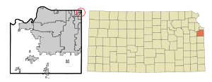
Location within Johnson County and Kansas
|
|

|
|
| Country | United States |
| State | Kansas |
| County | Johnson |
| Founded | 1930s |
| Incorporated | 1949 |
| Area | |
| • Total | 0.09 sq mi (0.23 km2) |
| • Land | 0.09 sq mi (0.23 km2) |
| • Water | 0.00 sq mi (0.00 km2) |
| Elevation | 890 ft (270 m) |
| Population
(2020)
|
|
| • Total | 203 |
| • Density | 2,260/sq mi (883/km2) |
| Time zone | UTC-6 (CST) |
| • Summer (DST) | UTC-5 (CDT) |
| ZIP code |
66205
|
| Area code | 913 |
| FIPS code | 20-47425 |
| GNIS ID | 485625 |
Mission Woods is a small city located in Johnson County, Kansas, in the United States. It's part of the larger Kansas City metropolitan area. According to the 2020 census, about 203 people live in Mission Woods.
Contents
History of Mission Woods
In the 1930s, a man named J. C. Nichols started building a neighborhood called Mission Hills. Mission Woods got its name from two things. First, there was a Native American mission built nearby a long time ago. Second, the area has many beautiful trees and a natural, wooded setting.
Mission Woods officially became a city in 1949. In 2014, it became one of the first places to get super-fast internet from Google Fiber. This made it a "fiberhood."
Geography of the City
Mission Woods is a very small city. The United States Census Bureau says it covers about 0.10 square miles (0.23 square kilometers). All of this area is land, with no large bodies of water.
Population and People
| Historical population | |||
|---|---|---|---|
| Census | Pop. | %± | |
| 1950 | 205 | — | |
| 1960 | 243 | 18.5% | |
| 1970 | 237 | −2.5% | |
| 1980 | 213 | −10.1% | |
| 1990 | 182 | −14.6% | |
| 2000 | 165 | −9.3% | |
| 2010 | 178 | 7.9% | |
| 2020 | 203 | 14.0% | |
| U.S. Decennial Census | |||
2020 Census Details
The 2020 United States census counted 203 people living in Mission Woods. There were 80 households, which are groups of people living in one home. Most of these households (64) were families.
The population density was about 2,281 people per square mile. Most of the people living here (about 82%) were white. A smaller number were Black or Asian. Some people were from other races or had a mix of backgrounds. About 3.5% of the population was Hispanic or Latino.
Many households (40%) had children under 18 living there. Most households (70%) were married couples. About 12.5% of homes had just one person living alone. The average household had 2.6 people.
About 23% of the people were under 18 years old. About 28% were 65 years or older. The average age in Mission Woods was 43.4 years.
2010 Census Details
In the census of 2010, there were 178 people in Mission Woods. There were 77 households and 53 families. The city had about 1,780 people per square mile.
Most of the people (97.8%) were White. A small number were African American or Asian.
About 25% of households had children under 18. Most (62%) were married couples. About 26% of homes had just one person living there.
The average age in 2010 was 54.5 years. About 18.5% of residents were under 18. About 26.4% were 65 or older.
Getting Around: Major Highways
You can reach Mission Woods using these main roads:
 US-56
US-56 US-169
Local Libraries
The Johnson County Library system provides library services for everyone living in Mission Woods.
See also
 In Spanish: Mission Woods para niños
 | William L. Dawson |
 | W. E. B. Du Bois |
 | Harry Belafonte |

