McLouth, Kansas facts for kids
Quick facts for kids
McLouth, Kansas
|
|
|---|---|

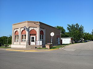
Street corner in downtown McLouth, July 2024
|
|

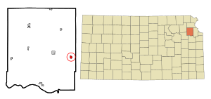
Location within Jefferson County and Kansas
|
|

|
|
| Country | United States |
| State | Kansas |
| County | Jefferson |
| Incorporated | 1881 |
| Named for | Amos McLouth |
| Area | |
| • Total | 0.58 sq mi (1.50 km2) |
| • Land | 0.58 sq mi (1.49 km2) |
| • Water | 0.01 sq mi (0.01 km2) |
| Elevation | 1,168 ft (356 m) |
| Population
(2020)
|
|
| • Total | 859 |
| • Density | 1,481/sq mi (572.7/km2) |
| Time zone | UTC-6 (CST) |
| • Summer (DST) | UTC-5 (CDT) |
| ZIP code |
66054
|
| Area code | 913 |
| GNIS ID | 2395075 |
McLouth is a city in Jefferson County, Kansas, United States. As of the 2020 census, the population of the city was 859 people.
Contents
History of McLouth
McLouth was founded in the 1880s. It was named after Amos McLouth. He was the first owner of the land where the town was built.
The first post office in McLouth opened in May 1882. Since 1957, McLouth has hosted the Threshing Bee and Fall Festival. This event celebrates old farm machines.
Geography of McLouth
McLouth covers a small area. It is about 0.60 square miles (1.55 km2) in total. Most of this area is land. A very small part is water.
People of McLouth
| Historical population | |||
|---|---|---|---|
| Census | Pop. | %± | |
| 1890 | 311 | — | |
| 1900 | 529 | 70.1% | |
| 1910 | 571 | 7.9% | |
| 1920 | 575 | 0.7% | |
| 1930 | 517 | −10.1% | |
| 1940 | 515 | −0.4% | |
| 1950 | 477 | −7.4% | |
| 1960 | 402 | −15.7% | |
| 1970 | 472 | 17.4% | |
| 1980 | 700 | 48.3% | |
| 1990 | 719 | 2.7% | |
| 2000 | 868 | 20.7% | |
| 2010 | 880 | 1.4% | |
| 2020 | 859 | −2.4% | |
| U.S. Decennial Census | |||
McLouth is part of the Topeka Metropolitan Statistical Area. This means it is part of the larger Topeka city area.
McLouth's Population in 2020
The 2020 United States census counted 859 people living in McLouth. There were 346 households, which are groups of people living together. About 232 of these were families.
Most people in McLouth are white. A small number of people are from other racial backgrounds. About 3.5% of the population is Hispanic or Latino.
About 34% of households had children under 18. Nearly half were married couples. The average household had about 2.8 people. The average family had about 3.3 people.
The median age in McLouth was 35.2 years. This means half the people were younger and half were older. About 27% of the population was under 18 years old.
McLouth's Population in 2010
In the census of 2010, there were 880 people in McLouth. There were 341 households. About 240 of these were families.
Most people were white. A small number of people were from other racial groups. About 1.1% of the population was Hispanic or Latino.
About 40% of households had children under 18. Over half were married couples living together. The average household had about 2.58 people. The average family had about 3.11 people.
The median age in 2010 was 32.2 years. About 31.5% of residents were under 18.
Education in McLouth
The McLouth USD 342 public school district serves the community. It has elementary, middle, and high schools. All these schools are on one campus. They are connected and share some facilities.
The district offers special education for young children. It also has programs for 4-year-olds who might need extra help. Students can attend from kindergarten through 12th grade. McLouth High School offers courses that give college credit.
In the 2014–2015 school year, there were 243 students in elementary school. The middle school had 115 students. The high school had 171 students.
See also
 In Spanish: McLouth para niños
 | Tommie Smith |
 | Simone Manuel |
 | Shani Davis |
 | Simone Biles |
 | Alice Coachman |

