Tecumseh, Kansas facts for kids
Quick facts for kids
Tecumseh, Kansas
|
|
|---|---|

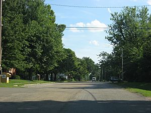
Central Tecumseh
|
|

|
|
| Country | United States |
| State | Kansas |
| County | Shawnee |
| Elevation | 912 ft (278 m) |
| Population | |
| • Total | 696 |
| Time zone | UTC-6 (CST) |
| • Summer (DST) | UTC-5 (CDT) |
| ZIP code |
66542
|
| Area code | 785 |
| FIPS code | 20-70075 |
| GNIS ID | 2804537 |
Tecumseh is a small community in Shawnee County, Kansas, United States. It is located right next to the Kansas River. In 2020, about 696 people lived there. The town and the area around it are named after a famous Shawnee chief.
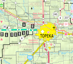
Tecumseh is also part of the larger Topeka metropolitan area. This means it is connected to the city of Topeka.
Contents
The History of Tecumseh
Early Days and Growth
Tecumseh was officially started on September 1, 1854. A man named Thomas Stinson planned out the town. This happened during a tough time in Kansas history called Bleeding Kansas. During this period, people argued a lot about whether Kansas should allow slavery.
Tecumseh was settled by people who supported slavery. For a short time, it was even the main town for those who wanted slavery in the Kansas Territory. The town grew and even had its own newspaper. A post office opened in Tecumseh in March 1855.
Changes Over Time
After the Civil War, Tecumseh became much smaller. It stayed a quiet place for about 90 years.
Things started to change in the 1920s. A power plant was built in Tecumseh between 1924 and 1925. Later, in 1958, a company called DuPont opened a cellophane factory nearby. This brought new jobs and helped the town grow a bit.
As the city of Topeka got bigger in the 1950s, Tecumseh began to grow again. Many new homes were built, and it became a place where people lived if they worked in Topeka. The power plant, known as the Tecumseh Energy Center, closed down in 2018 and was later taken apart.
Where is Tecumseh Located?
Tecumseh is found south of the Kansas River. It is located between two creeks: Tecumseh Creek to the east and Stinson Creek to the west. The town is completely within Tecumseh Township. It is only about 2 miles east of the Topeka city limits.
U.S. Route 40 runs along the south side of Tecumseh. A train track, used by BNSF, passes north of the town, between Tecumseh and the river. This track connects Lawrence and Topeka.
Population of Tecumseh
| Historical population | |||
|---|---|---|---|
| Census | Pop. | %± | |
| 2020 | 696 | — | |
| U.S. Decennial Census | |||
As of the 2020 census, 696 people lived in Tecumseh.
What's in Tecumseh?
The community of Tecumseh has a public school, which is part of the USD 450 school district. There are also two churches and a post office. The cellophane factory is another important part of the local economy.
Schools in Tecumseh
Students in Tecumseh attend schools in the Shawnee Heights USD 450 public school district.
 | DeHart Hubbard |
 | Wilma Rudolph |
 | Jesse Owens |
 | Jackie Joyner-Kersee |
 | Major Taylor |


