Wakarusa, Kansas facts for kids
Quick facts for kids
Wakarusa, Kansas
|
|
|---|---|

|
|
| Country | United States |
| State | Kansas |
| County | Shawnee |
| Area | |
| • Total | 4.999 sq mi (12.95 km2) |
| • Land | 4.965 sq mi (12.86 km2) |
| • Water | 0.034 sq mi (0.09 km2) |
| Elevation | 951 ft (290 m) |
| Population
(2020)
|
|
| • Total | 242 |
| • Density | 48.41/sq mi (18.69/km2) |
| Time zone | UTC-6 (CST) |
| • Summer (DST) | UTC-5 (CDT) |
| ZIP code |
66546
|
| Area code | 785 |
| FIPS code | 20-74425 |
| GNIS ID | 2629183 |
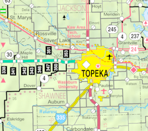
Wakarusa is a small community in Shawnee County, Kansas, United States. It is known as a census-designated place (CDP). A CDP is a special area that the United States Census Bureau defines for gathering statistics. It is not an officially incorporated town or city.
In 2020, the population of Wakarusa was 242 people. This community is located about 11 miles (18 km) south of downtown Topeka. There is also another place called Wakarusa in nearby Douglas County, Kansas.
History of Wakarusa
Wakarusa was first established in 1858. It has its own post office with the ZIP code 66546. This helps people send and receive mail in the area.
Population Information
| Historical population | |||
|---|---|---|---|
| Census | Pop. | %± | |
| 2010 | 260 | — | |
| 2020 | 242 | −6.9% | |
| U.S. Decennial Census | |||
The United States Census Bureau collects information about how many people live in different areas. They use this data for statistical reasons. Wakarusa is one of these areas, defined as a census-designated place (CDP).
Schools in Wakarusa
Students in Wakarusa attend public schools. The community is part of the Auburn–Washburn USD 437 school district. This district provides education for children living in the area.
See also
 In Spanish: Wakarusa (Kansas) para niños
 | Calvin Brent |
 | Walter T. Bailey |
 | Martha Cassell Thompson |
 | Alberta Jeannette Cassell |


