Geary County, Kansas facts for kids
Quick facts for kids
Geary County
|
|
|---|---|

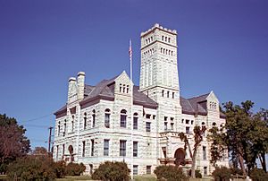
Geary County Courthouse in Junction City (1979)
|
|

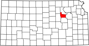
Location within the U.S. state of Kansas
|
|
 Kansas's location within the U.S. |
|
| Country | |
| State | |
| Founded | 1855 |
| Named for | John W. Geary |
| Seat | Junction City |
| Largest city | Junction City |
| Area | |
| • Total | 404 sq mi (1,050 km2) |
| • Land | 385 sq mi (1,000 km2) |
| • Water | 20 sq mi (50 km2) 4.9%% |
| Population
(2020)
|
|
| • Total | 36,739 |
| • Estimate
(2023)
|
35,047 |
| • Density | 95.4/sq mi (36.8/km2) |
| Time zone | UTC−6 (Central) |
| • Summer (DST) | UTC−5 (CDT) |
| Congressional district | 2nd |
Geary County is a county in the U.S. state of Kansas. Its main city and county seat is Junction City. In 2020, about 36,739 people lived here. The county is named after John W. Geary. He was the first mayor of San Francisco and a governor of the Kansas Territory.
Contents
History of Geary County
How did Geary County begin?
For thousands of years, nomadic Native Americans lived on the Great Plains of North America. From the 1500s to the 1700s, France claimed much of North America. In 1762, France secretly gave New France to Spain after a war.
In 1802, Spain returned most of the land to France. Then, in 1803, the United States bought a huge area from France. This was called the Louisiana Purchase. It included most of modern-day Kansas.
When was Geary County formed?
The Kansas Territory was set up in 1854. Kansas became the 34th U.S. state in 1861. Geary County was officially formed on August 30, 1855. It was one of the first 33 counties created by the territory government.
Geary County was first called Davis County in 1855. It was named after Jefferson Davis, who was then the United States Secretary of War. During the American Civil War, Davis became president of the Confederacy. People tried to change the county's name, but it stayed Davis County until 1888. That year, the county was renamed to honor John W. Geary, an early Governor of the Kansas Territory.
Geography of Geary County
Geary County covers about 404 square miles. About 385 square miles are land, and 20 square miles (4.9%) are water. It is one of the smallest counties in Kansas.
What counties are next to Geary County?
- Riley County (north)
- Wabaunsee County (east)
- Morris County (south)
- Dickinson County (west)
- Clay County (northwest)
Population and People
| Historical population | |||
|---|---|---|---|
| Census | Pop. | %± | |
| 1860 | 1,163 | — | |
| 1870 | 5,526 | 375.2% | |
| 1880 | 6,994 | 26.6% | |
| 1890 | 10,428 | 49.1% | |
| 1900 | 10,744 | 3.0% | |
| 1910 | 12,681 | 18.0% | |
| 1920 | 13,452 | 6.1% | |
| 1930 | 14,366 | 6.8% | |
| 1940 | 15,222 | 6.0% | |
| 1950 | 21,671 | 42.4% | |
| 1960 | 28,779 | 32.8% | |
| 1970 | 28,111 | −2.3% | |
| 1980 | 29,852 | 6.2% | |
| 1990 | 30,453 | 2.0% | |
| 2000 | 27,947 | −8.2% | |
| 2010 | 34,362 | 23.0% | |
| 2020 | 36,739 | 6.9% | |
| 2023 (est.) | 35,047 | 2.0% | |
| U.S. Decennial Census 1790–1960 1900–1990 1990–2000 2010–2020 |
|||
Geary County is part of the Manhattan, KS Metropolitan Statistical Area. This means it's part of a larger city area.
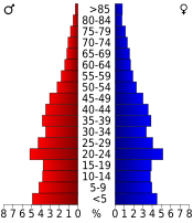
In 2000, there were 27,947 people living in the county. The population density was about 73 people per square mile. The county's population includes people from many different backgrounds.
Education in Geary County
What schools are in Geary County?
- Geary County USD 475 is the main school district.
Communities in Geary County
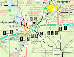
Here are the cities and communities you can find in Geary County:
Cities in Geary County
- Grandview Plaza
- Junction City (This is the county seat)
- Milford
Unincorporated communities
These are places that are not officially cities.
- Fort Riley†‡ (This place is also a Census-Designated Place and has parts in another county.)
- Wreford
Ghost towns
These are towns that no longer exist.
- Alida (This town was removed when Milford Lake was built.)
- Pawnee
Fort Riley Military Base
Fort Riley is a large military base. It is located north of where the Smoky Hill and Republican rivers meet. The base covers about 100,656 acres in Geary and Riley counties. Nearly 25,000 people work or live at Fort Riley during the day.
Townships
Geary County is divided into eight areas called townships. The city of Junction City is separate from these townships for census counting.
See also
 In Spanish: Condado de Geary para niños
 | Janet Taylor Pickett |
 | Synthia Saint James |
 | Howardena Pindell |
 | Faith Ringgold |


