Republican River facts for kids
Quick facts for kids Republican River |
|
|---|---|

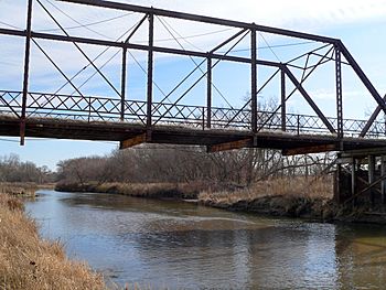
The Republican River near Riverton, Nebraska
|
|

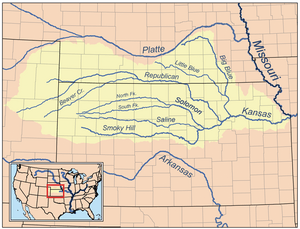
Map of the Kansas River drainage basin showing the Republican River
|
|
| Other name(s) | Forche des Republiques, Coster Blanches, Ki-ra-ru-tah, Mahohevaohe |
| Country | United States |
| States | Nebraska, Kansas |
| Physical characteristics | |
| River mouth | Kansas River Junction City, Kansas 1,043 ft (318 m) 39°03′36″N 98°48′05″W / 39.06000°N 98.80139°W |
| Length | 453 mi (729 km) |
| Basin features | |
| Basin size | 24,900 sq mi (64,000 km2) |
| Tributaries | |
| Watersheds | Republican-Kansas-Missouri-Mississippi |
The Republican River is an important river in the central Great Plains region of North America. It begins in the High Plains of eastern Colorado. From there, it flows east for about 453 miles (729 kilometers) through the U.S. states of Nebraska and Kansas.
Contents
About the Republican River
The Republican River is a key waterway for the areas it flows through. It helps support farms and communities by providing water. The river's name comes from the "Republican Pawnee" Native American tribe, who used to live along its banks.
Where Does It Flow?
The river starts where two smaller rivers, the Arikaree River and the North Fork Republican River, meet near Haigler, Nebraska. This starting point is about 3,253 feet (992 meters) above sea level. The river then travels across Nebraska and Kansas. Finally, it joins the Kansas River near Junction City, Kansas. At this point, the river is about 1,043 feet (318 meters) above sea level.
How Big Is It?
The Republican River is about 453 miles (729 kilometers) long. It drains a large area of land called a drainage basin or watershed. This basin covers about 24,900 square miles (64,000 square kilometers). This means all the rain and snow that falls in this huge area eventually flows into the Republican River.
The amount of water in the river changes throughout the year. Near Junction City, Kansas, the river's average flow is about 848 cubic feet per second (24 cubic meters per second). This is like filling 24 large boxes with water every second! Sometimes, during heavy rains, the river can flow much faster, up to 33,300 cubic feet per second (943 cubic meters per second).
Rivers That Join It
Many smaller rivers and creeks flow into the Republican River. These are called tributaries. On its left side, some of the main tributaries are:
On its right side, some important tributaries include:
Part of a Bigger System
The Republican River is part of a much larger river system. After it joins the Kansas River, the water eventually flows into the Missouri River. The Missouri River then flows into the mighty Mississippi River. This means water from the Republican River eventually makes its way all the way to the Gulf of Mexico!
Images for kids
-
June 24, 1947, flood of the Republican River near Hardy, Nebraska and Webber, Kansas.
See also
 In Spanish: Río Republican para niños
 | Audre Lorde |
 | John Berry Meachum |
 | Ferdinand Lee Barnett |


