North Fork Republican River facts for kids
Quick facts for kids North Fork Republican River |
|
|---|---|

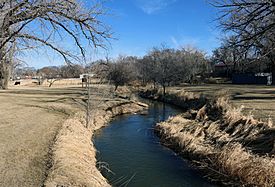
The river in Wray, Colorado.
|
|
| Other name(s) | Wi'hiuniyohe |
| Country | United States |
| State | Colorado, Nebraska |
| Physical characteristics | |
| Main source | Yuma County, Colorado 3,860 ft (1,180 m) 39°59′58″N 102°27′14″W / 39.99944°N 102.45389°W |
| River mouth | Republican River Haigler, Nebraska 3,241 ft (988 m) 40°01′11″N 101°56′18″W / 40.01972°N 101.93833°W |
| Length | 55 mi (89 km) |
| Basin features | |
| Basin size | 5,086 sq mi (13,170 km2) |
| Watersheds | North Fork Republican- Republican-Kansas-Missouri- Mississippi |
The North Fork Republican River is a river in the United States. It is about 55 miles (89 km) long. This river is a branch, or tributary, of the Republican River.
The North Fork Republican River starts in Yuma County, Colorado. It then flows east. It ends just north of Haigler, Nebraska in Dundy County, Nebraska. Here, it meets another river called the Arikaree River. Together, they form the main Republican River.
Where the River Flows
The North Fork Republican River collects water from a very large area. This area is called its drainage basin. The basin covers about 5,086 square miles (13,170 km²).
Most of this area is in eastern Colorado. About 4,449 square miles (11,520 km²) are in Colorado. A smaller part, about 575 square miles (1,490 km²), is in southwestern Nebraska. The smallest part, about 62 square miles (160 km²), is in northwestern Kansas.
Sharing the Water
The water from the North Fork Republican River is important to several states. Because of this, the states of Colorado, Nebraska, and Kansas have an agreement. This agreement is called the Republican River Compact.
This compact is a special deal about how to share the river's water. It was signed on December 31, 1942. Agreements like this help make sure everyone gets enough water. They also prevent arguments between states.
 | Percy Lavon Julian |
 | Katherine Johnson |
 | George Washington Carver |
 | Annie Easley |

