Dundy County, Nebraska facts for kids
Quick facts for kids
Dundy County
|
|
|---|---|

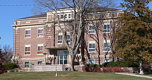
Dundy County Courthouse in Benkelman
|
|

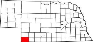
Location within the U.S. state of Nebraska
|
|
 Nebraska's location within the U.S. |
|
| Country | |
| State | |
| Founded | 1873 (authorized) 1884 (organized) |
| Named for | Elmer Scipio Dundy |
| Seat | Benkelman |
| Largest city | Benkelman |
| Area | |
| • Total | 921 sq mi (2,390 km2) |
| • Land | 920 sq mi (2,400 km2) |
| • Water | 1.2 sq mi (3 km2) 0.1%% |
| Population
(2020)
|
|
| • Total | 1,654 |
| • Density | 2.0/sq mi (0.8/km2) |
| Time zone | UTC−7 (Mountain) |
| • Summer (DST) | UTC−6 (MDT) |
| Congressional district | 3rd |
Dundy County is a place in the state of Nebraska, USA. In 2020, about 1,654 people lived there. The main town, or "county seat," is Benkelman.
If you see a Nebraska license plate with '76' on it, it means the car is from Dundy County! This number was given in 1922 based on how many cars were registered there.
Contents
History of Dundy County
Dundy County was created in 1873. At first, it was connected to Hitchcock County. It was named after a judge named Elmer Scipio Dundy. The county officially started its own government in 1884.
Geography of Dundy County
Dundy County is located in the very southwest corner of Nebraska. Its western border touches the state of Colorado. Its southern border touches the state of Kansas.
According to the US Census Bureau, the county covers about 921 square miles (2,385 square kilometers). Most of this area, about 920 square miles (2,383 square kilometers), is land. Only a small part, about 1.2 square miles (3.1 square kilometers), is water.
Main Roads in Dundy County
Neighboring Counties
Dundy County shares borders with several other counties:
- Hitchcock County – to the east
- Rawlins County, Kansas – to the southeast
- Cheyenne County, Kansas – to the south
- Yuma County, Colorado – to the west
- Chase County – to the north
- Hayes County – to the northeast
Parks and Protected Areas
- Rock Creek State Recreation Area is a special place in Dundy County where people can enjoy nature.
Population Changes Over Time
| Historical population | |||
|---|---|---|---|
| Census | Pop. | %± | |
| 1880 | 37 | — | |
| 1890 | 4,012 | 10,743.2% | |
| 1900 | 2,434 | −39.3% | |
| 1910 | 4,098 | 68.4% | |
| 1920 | 4,869 | 18.8% | |
| 1930 | 5,610 | 15.2% | |
| 1940 | 5,122 | −8.7% | |
| 1950 | 4,354 | −15.0% | |
| 1960 | 3,570 | −18.0% | |
| 1970 | 2,926 | −18.0% | |
| 1980 | 2,861 | −2.2% | |
| 1990 | 2,582 | −9.8% | |
| 2000 | 2,292 | −11.2% | |
| 2010 | 2,008 | −12.4% | |
| 2020 | 1,654 | −17.6% | |
| 2021 (est.) | 1,635 | −18.6% | |
| US Decennial Census 1790–1960 1900–1990 1990–2000 2010–2013 |
|||
The population of Dundy County has changed a lot over the years. In 1880, only 37 people lived there. The population grew quite a bit in the early 1900s, reaching its highest point in 1930 with 5,610 people. Since then, the number of people living in Dundy County has slowly decreased. In 2020, there were 1,654 residents.
Towns and Communities
City
- Benkelman (This is the county seat, meaning it's the main town where the county government is located.)
Village
Census-Designated Places
These are areas that are like towns but are not officially incorporated as cities or villages.
- Max
- Parks
Other Unincorporated Communities
These are smaller communities that are not officially part of a city or village.
Former Community
- Ough (This community no longer exists.)
See also
 In Spanish: Condado de Dundy para niños
 | Jessica Watkins |
 | Robert Henry Lawrence Jr. |
 | Mae Jemison |
 | Sian Proctor |
 | Guion Bluford |

