Hitchcock County, Nebraska facts for kids
Quick facts for kids
Hitchcock County
|
|
|---|---|

Hitchcock County courthouse in Trenton
|
|

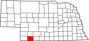
Location within the U.S. state of Nebraska
|
|
 Nebraska's location within the U.S. |
|
| Country | |
| State | |
| Founded | 1873 |
| Named for | Phineas Hitchcock |
| Seat | Trenton |
| Largest village | Culbertson |
| Area | |
| • Total | 718 sq mi (1,860 km2) |
| • Land | 710 sq mi (1,800 km2) |
| • Water | 8.5 sq mi (22 km2) 1.2%% |
| Population
(2020)
|
|
| • Total | 2,616 |
| • Density | 4.0/sq mi (1.5/km2) |
| Time zone | UTC−6 (Central) |
| • Summer (DST) | UTC−5 (CDT) |
| Congressional district | 3rd |
Hitchcock County is a county located in the state of Nebraska, USA. In 2020, about 2,616 people lived there. Its main town, or county seat, is Trenton.
When Nebraska created its license plate system in 1922, Hitchcock County was given the number 67. This was because it had the sixty-seventh largest number of vehicles registered in the county at that time.
Contents
History of Hitchcock County
Hitchcock County was officially created in 1873. It was named after Phineas Warren Hitchcock, who was a US Senator.
An important event in the county's history is the Massacre Canyon battle. This battle took place on August 5, 1873. It was fought between the Sioux and Pawnee Native American tribes. The battle happened about three miles east of Trenton.
Geography of Hitchcock County
The land in Hitchcock County has gently rolling hills. The flat tops of these hills are used for farming. Farmers mostly use a method called dry farming, which means they grow crops without irrigation. Some areas also use center pivot irrigation, which is a way to water crops using a rotating system.
The Republican River flows eastward through the middle of the county. The county covers a total area of 718 square miles. Most of this (710 square miles) is land, and 8.5 square miles (1.2%) is water.
Nebraska has two time zones. The eastern two-thirds of the state uses Central Time. The western part uses Mountain Time. Hitchcock County is the westernmost county in Nebraska that observes Central Time.
Lakes in Hitchcock County
- Swanson Lake: This lake was formed by a dam on the Republican River. It is located between the towns of Stratton and Trenton.
Major Highways
Counties Next to Hitchcock County
- Red Willow County – to the east
- Rawlins County, Kansas – to the south
- Dundy County – to the west (this is where the Mountain Time Zone begins)
- Hayes County – to the north
- Frontier County – to the northeast
Population Changes
| Historical population | |||
|---|---|---|---|
| Census | Pop. | %± | |
| 1880 | 1,012 | — | |
| 1890 | 5,799 | 473.0% | |
| 1900 | 4,409 | −24.0% | |
| 1910 | 5,415 | 22.8% | |
| 1920 | 6,045 | 11.6% | |
| 1930 | 7,269 | 20.2% | |
| 1940 | 6,404 | −11.9% | |
| 1950 | 5,867 | −8.4% | |
| 1960 | 4,829 | −17.7% | |
| 1970 | 4,051 | −16.1% | |
| 1980 | 4,079 | 0.7% | |
| 1990 | 3,750 | −8.1% | |
| 2000 | 3,111 | −17.0% | |
| 2010 | 2,908 | −6.5% | |
| 2020 | 2,616 | −10.0% | |
| 2021 (est.) | 2,586 | −11.1% | |
| US Decennial Census 1790-1960 1900-1990 1990-2000 2010-2013 |
|||
In 2000, there were 3,111 people living in Hitchcock County. The population density was about 4 people per square mile. The average age of people in the county was 44 years old.
Towns and Villages
Villages
- Culbertson
- Palisade (part of this village is in another county)
- Stratton
- Trenton (this is the county seat)
Former Communities
These are places that used to be communities in Hitchcock County but are no longer active towns or villages.
- Beverly
- Blackwood
- Cornell
- Dike
- Driftwood
- Meeker
- Poe
- Rill
- Rupert
See also
 In Spanish: Condado de Hitchcock para niños
 | Roy Wilkins |
 | John Lewis |
 | Linda Carol Brown |

