Hayes County, Nebraska facts for kids
Quick facts for kids
Hayes County
|
|
|---|---|

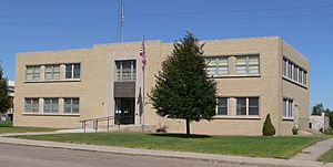
Hayes County courthouse in Hayes Center
|
|

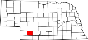
Location within the U.S. state of Nebraska
|
|
 Nebraska's location within the U.S. |
|
| Country | |
| State | |
| Founded | 1877 (founded) February 19, 1884 (organized) |
| Named for | Rutherford B. Hayes |
| Seat | Hayes Center |
| Largest village | Palisade |
| Area | |
| • Total | 713 sq mi (1,850 km2) |
| • Land | 713 sq mi (1,850 km2) |
| • Water | 0.2 sq mi (0.5 km2) 0.03%% |
| Population
(2020)
|
|
| • Total | 856 |
| • Density | 1.2/sq mi (0.5/km2) |
| Time zone | UTC−6 (Central) |
| • Summer (DST) | UTC−5 (CDT) |
| Congressional district | 3rd |
Hayes County is a special area in the state of Nebraska, USA. It's like a smaller region within the state. In 2020, about 856 people lived there. The main town, or county seat, is Hayes Center. This is where the county government offices are.
Hayes County was first set up in 1877. It officially started working as a county in 1884. It got its name from Rutherford B. Hayes, who was the US President when the county was created. If you see a Nebraska license plate with the number 79, it means the car is from Hayes County! This number was given because it had the 79th largest number of registered vehicles in 1922.
Contents
Geography of Hayes County
The land in Hayes County has many hills. The flat tops of these hills are mostly used for farming. Farmers often use a special watering system called center pivot irrigation to grow crops. Small creeks and streams flow from the higher areas. The biggest one is Red Willow Creek. It flows into Hugh Butler Lake, which is just east of the county. Hayes County covers about 713 square miles (1,847 square kilometers) of land. Only a tiny bit of this area is water.
Main Roads
Neighboring Counties
Hayes County shares borders with these other counties:
- Frontier County – to the east
- Hitchcock County – to the south
- Dundy County – to the southwest
- Chase County – to the west
- Perkins County – to the northwest
- Lincoln County – to the north
Population Changes Over Time
| Historical population | |||
|---|---|---|---|
| Census | Pop. | %± | |
| 1880 | 119 | — | |
| 1890 | 3,953 | 3,221.8% | |
| 1900 | 2,708 | −31.5% | |
| 1910 | 3,011 | 11.2% | |
| 1920 | 3,327 | 10.5% | |
| 1930 | 3,603 | 8.3% | |
| 1940 | 2,958 | −17.9% | |
| 1950 | 2,404 | −18.7% | |
| 1960 | 1,919 | −20.2% | |
| 1970 | 1,530 | −20.3% | |
| 1980 | 1,356 | −11.4% | |
| 1990 | 1,222 | −9.9% | |
| 2000 | 1,068 | −12.6% | |
| 2010 | 967 | −9.5% | |
| 2020 | 856 | −11.5% | |
| US Decennial Census 1790-1960 1900-1990 1990-2000 2010 |
|||
The population of Hayes County has changed a lot over the years. In 1880, only 119 people lived there. The population grew quite a bit by 1890, reaching 3,953 people. Since then, the number of people living in Hayes County has slowly decreased. In 2020, the population was 856.
In 2000, the average age of people in Hayes County was 42 years old. About 26.6% of the people were under 18 years old.
Communities in Hayes County
Hayes County has a few small towns and places where people live.
Villages
- Hamlet
- Hayes Center (This is the county seat, where the main county offices are.)
- Palisade (Part of this village is in Hayes County.)
Unincorporated Community
- Marengo (This is a small community that is not officially a village or town.)
Townships
Unlike many other counties in Nebraska, Hayes County is not divided into smaller areas called townships.
Past Communities
- Carrico
- Eddy
- Elmer
- Estel
- Galena
- Highland
- Hope
- Hudson
- Marengo
- Norris
- Robert
- Strickland
- Sullivan
- Thornburgh
- White
See also
 In Spanish: Condado de Hayes para niños
 | Stephanie Wilson |
 | Charles Bolden |
 | Ronald McNair |
 | Frederick D. Gregory |

