Perkins County, Nebraska facts for kids
Quick facts for kids
Perkins County
|
|
|---|---|

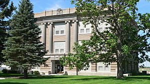
Perkins County Courthouse in Grant
|
|

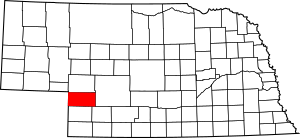
Location within the U.S. state of Nebraska
|
|
 Nebraska's location within the U.S. |
|
| Country | |
| State | |
| Founded | 1887 |
| Named for | Charles Elliott Perkins |
| Seat | Grant |
| Largest city | Grant |
| Area | |
| • Total | 884 sq mi (2,290 km2) |
| • Land | 883 sq mi (2,290 km2) |
| • Water | 1.1 sq mi (3 km2) 0.1%% |
| Population
(2020)
|
|
| • Total | 2,858 |
| • Density | 3.2330/sq mi (1.2483/km2) |
| Time zone | UTC−7 (Mountain) |
| • Summer (DST) | UTC−6 (MDT) |
| Congressional district | 3rd |
Perkins County is a place in the state of Nebraska, USA. It is known as a county. In 2020, about 2,858 people lived here. The main town and government center is Grant.
When you see Nebraska license plates, Perkins County has the number 74. This number was given in 1922 based on how many vehicles were registered in the county back then.
Contents
History of Perkins County
Perkins County was officially started in 1887. It is thought to be named after Charles Elliott Perkins. He was the president of a big railroad company called the Chicago, Burlington and Quincy Railroad.
Geography of Perkins County
Perkins County is located in the southwest part of Nebraska. Its western border touches the state of Colorado. The land here has low, rolling hills and is quite dry.
Flat areas are used for farming. Farmers often use a special watering system called center pivot irrigation. The land gently slopes down towards the southeast.
The county covers about 884 square miles. Most of this (883 square miles) is land, and a very small part (1.1 square miles) is water.
Most counties in Nebraska use Central Time. However, Perkins County is in the western part of the state. Because of this, it uses Mountain Time. It is the most eastern county in Nebraska to observe Mountain Time.
Main Roads
Neighboring Counties
- Lincoln County – to the east (uses Central Time)
- Hayes County – to the southeast (uses Central Time)
- Chase County – to the south
- Phillips County, Colorado – to the southwest
- Sedgwick County, Colorado – to the west
- Deuel County – to the northwest
- Keith County – to the north
Population Changes
| Historical population | |||
|---|---|---|---|
| Census | Pop. | %± | |
| 1890 | 4,364 | — | |
| 1900 | 1,702 | −61.0% | |
| 1910 | 2,570 | 51.0% | |
| 1920 | 3,967 | 54.4% | |
| 1930 | 5,834 | 47.1% | |
| 1940 | 5,197 | −10.9% | |
| 1950 | 4,809 | −7.5% | |
| 1960 | 4,189 | −12.9% | |
| 1970 | 3,423 | −18.3% | |
| 1980 | 3,637 | 6.3% | |
| 1990 | 3,367 | −7.4% | |
| 2000 | 3,200 | −5.0% | |
| 2010 | 2,970 | −7.2% | |
| 2020 | 2,858 | −3.8% | |
| 2022 (est.) | 2,829 | −4.7% | |
| US Decennial Census 1790-1960 1900-1990 1990-2000 2010 2020 2022 |
|||
In 2000, there were 3,200 people living in Perkins County. There were 1,275 homes, and 893 of these were families. The population density was about 4 people per square mile.
About 32.5% of homes had children under 18 living there. Most homes (62.9%) were married couples. About 27.5% of all homes were single people living alone.
The average age of people in the county was 41 years old. About 26.6% of the population was under 18.
Towns and Villages
City
- Grant (This is the county seat, where the main government offices are.)
Villages
Other Communities
See also
 In Spanish: Condado de Perkins (Nebraska) para niños
 | DeHart Hubbard |
 | Wilma Rudolph |
 | Jesse Owens |
 | Jackie Joyner-Kersee |
 | Major Taylor |

