Sedgwick County, Colorado facts for kids
Quick facts for kids
Sedgwick County
|
|
|---|---|

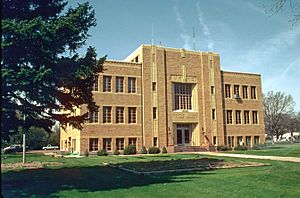
Sedgwick County Courthouse, Julesburg
|
|

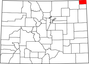
Location within the U.S. state of Colorado
|
|
 Colorado's location within the U.S. |
|
| Country | |
| State | |
| Founded | April 9, 1889 |
| Named for | John Sedgwick |
| Seat | Julesburg |
| Largest town | Julesburg |
| Area | |
| • Total | 549 sq mi (1,420 km2) |
| • Land | 548 sq mi (1,420 km2) |
| • Water | 1.4 sq mi (4 km2) 0.2%% |
| Population
(2020)
|
|
| • Total | 2,404 |
| • Estimate
(2023)
|
2,299 |
| • Density | 4.379/sq mi (1.6907/km2) |
| Time zone | UTC−7 (Mountain) |
| • Summer (DST) | UTC−6 (MDT) |
| Congressional district | 4th |
Sedgwick County is a county found in the state of Colorado in the United States. In 2020, about 2,404 people lived there. The main town, or county seat, is Julesburg. The county got its name from Fort Sedgwick. This fort was a military base along the Platte Trail. It was named after General John Sedgwick. Sedgwick County is right on the border with Nebraska.
Contents
History of Sedgwick County
Sedgwick County was named after John Sedgwick. He was a very important general, a major general, in the Union Army. This was during the American Civil War. The county was officially created on April 9, 1889.
Geography and Location
Sedgwick County covers a total area of about 549 square miles. Most of this area, 548 square miles, is land. Only a small part, about 1.4 square miles, is water. This means water makes up only 0.2% of the county's total area.
Neighboring Counties and States
Sedgwick County shares its borders with several other counties and states.
- To the north, it borders Deuel County, Nebraska.
- To the east, it is next to Perkins County, Nebraska.
- To the south, you will find Phillips County.
- To the west, it borders Logan County.
- To the northwest, it is next to Cheyenne County, Nebraska.
Main Roads and Highways
Several important roads pass through Sedgwick County. These highways help people travel and connect different towns.
Historic Trails and Scenic Routes
Sedgwick County is home to several famous trails and byways. These routes have historical importance.
- American Discovery Trail: A long trail for hiking and biking across the U.S.
- First transcontinental railroad: The route of the first railroad that crossed the entire country.
- Pony Express National Historic Trail: A historic route used by mail riders on horseback.
- South Platte River Trail Scenic and Historic Byway: A scenic road along the South Platte River.
- South Platte Trail: Another historic trail in the area.
- Upper Crossing of the California Trail: A part of the trail used by pioneers heading to California.
Population of Sedgwick County
| Historical population | |||
|---|---|---|---|
| Census | Pop. | %± | |
| 1890 | 1,293 | — | |
| 1900 | 971 | −24.9% | |
| 1910 | 3,061 | 215.2% | |
| 1920 | 4,207 | 37.4% | |
| 1930 | 5,580 | 32.6% | |
| 1940 | 5,294 | −5.1% | |
| 1950 | 5,095 | −3.8% | |
| 1960 | 4,242 | −16.7% | |
| 1970 | 3,405 | −19.7% | |
| 1980 | 3,266 | −4.1% | |
| 1990 | 2,690 | −17.6% | |
| 2000 | 2,747 | 2.1% | |
| 2010 | 2,379 | −13.4% | |
| 2020 | 2,404 | 1.1% | |
| 2023 (est.) | 2,299 | −3.4% | |
| U.S. Decennial Census 1790-1960 1900–1990 1990-2000 2010–2020 |
|||
In 2020, the population of Sedgwick County was 2,404 people. The county's population has changed over the years. For example, in 1930, there were 5,580 people. By 2010, the number had dropped to 2,379. The population is estimated to be around 2,299 in 2023.
Towns in Sedgwick County
Sedgwick County has a few towns where people live.
Towns
See also
 In Spanish: Condado de Sedgwick (Colorado) para niños
 | Jessica Watkins |
 | Robert Henry Lawrence Jr. |
 | Mae Jemison |
 | Sian Proctor |
 | Guion Bluford |

