Deuel County, Nebraska facts for kids
Quick facts for kids
Deuel County
|
|
|---|---|

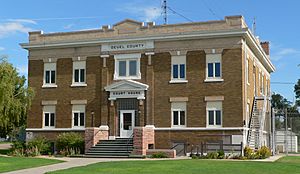
Deuel County Courthouse in Chappell
|
|

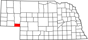
Location within the U.S. state of Nebraska
|
|
 Nebraska's location within the U.S. |
|
| Country | |
| State | |
| Founded | 1889 |
| Named for | Harry P. Deuel |
| Seat | Chappell |
| Largest city | Chappell |
| Area | |
| • Total | 441 sq mi (1,140 km2) |
| • Land | 440 sq mi (1,100 km2) |
| • Water | 0.9 sq mi (2 km2) 0.2%% |
| Population
(2020)
|
|
| • Total | 1,838 |
| • Density | 4.168/sq mi (1.6092/km2) |
| Time zone | UTC−7 (Mountain) |
| • Summer (DST) | UTC−6 (MDT) |
| Congressional district | 3rd |
Deuel County is a special area called a county in the state of Nebraska, USA. It's like a small region with its own local government. In 2020, about 1,838 people lived here.
The main town, or county seat, of Deuel County is Chappell. The county was created in 1889. It was named after Harry Porter Deuel. He was an important person who worked for the Union Pacific Railroad.
Did you know? In Nebraska, license plates have numbers that show which county a car is from. Deuel County's number is 78. This number was given because it had the 78th largest number of registered vehicles when the system started in 1922.
Contents
Where is Deuel County?
Deuel County is located in the western part of Nebraska. Its southern border touches the state of Colorado. The total area of the county is about 441 square miles. Most of this is land, with a tiny bit of water.
Because Deuel County is in western Nebraska, people there use Mountain Time. This is different from eastern Nebraska, which uses Central Time.
Main Roads in Deuel County
Many important roads pass through Deuel County. These roads help people travel and transport goods.
 Interstate 80
 U.S. Highway 30
 U.S. Highway 138
 U.S. Highway 385
 Nebraska Highway 27
Neighboring Counties
Deuel County shares its borders with several other counties.
- Garden County to the north
- Keith County to the east
- Perkins County to the southeast
- Sedgwick County, Colorado to the south (in Colorado)
- Cheyenne County to the west
Who Lives in Deuel County?
The number of people living in Deuel County has changed over the years. Here's a look at the population from different census years:
| Historical population | |||
|---|---|---|---|
| Census | Pop. | %± | |
| 1890 | 2,893 | — | |
| 1900 | 2,630 | −9.1% | |
| 1910 | 1,786 | −32.1% | |
| 1920 | 3,282 | 83.8% | |
| 1930 | 3,992 | 21.6% | |
| 1940 | 3,580 | −10.3% | |
| 1950 | 3,330 | −7.0% | |
| 1960 | 3,125 | −6.2% | |
| 1970 | 2,717 | −13.1% | |
| 1980 | 2,462 | −9.4% | |
| 1990 | 2,237 | −9.1% | |
| 2000 | 2,098 | −6.2% | |
| 2010 | 1,941 | −7.5% | |
| 2020 | 1,838 | −5.3% | |
| 2022 (est.) | 1,902 | −2.0% | |
| US Decennial Census 1790-1960 1900-1990 1990-2000 2010 2020 2022 |
|||
In 2000, there were 2,098 people living in the county. Most people in Deuel County are White. Some people also have German, Irish, English, or Swedish family backgrounds.
The average age of people in the county in 2000 was 44 years old. About 23% of the population was under 18 years old.
Towns and Villages
Deuel County has a few places where people live.
City
- Chappell (This is the county seat, meaning it's the center for county government.)
Village
Unincorporated Community
- Barton (This is a smaller community without its own local government.)
See also
 In Spanish: Condado de Deuel (Nebraska) para niños
 | Laphonza Butler |
 | Daisy Bates |
 | Elizabeth Piper Ensley |

