
Keith County, Nebraska facts for kids
Quick facts for kids
Keith County
|
|
|---|---|

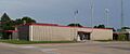
Keith County Courthouse in Ogallala
|
|

Location within the U.S. state of Nebraska
|
|
 Nebraska's location within the U.S. |
|
| Country | |
| State | |
| Founded | 1873 |
| Named for | M.C. Keith or John Keith |
| Seat | Ogallala |
| Largest city | Ogallala |
| Area | |
| • Total | 1,110 sq mi (2,900 km2) |
| • Land | 1,062 sq mi (2,750 km2) |
| • Water | 48 sq mi (120 km2) 4.3%% |
| Population
(2020)
|
|
| • Total | 8,335 |
| • Density | 7.51/sq mi (2.899/km2) |
| Time zone | UTC−7 (Mountain) |
| • Summer (DST) | UTC−6 (MDT) |
| Congressional district | 3rd |
Keith County is a county located in the state of Nebraska in the United States. In 2020, about 8,335 people lived here. The main town and county seat is Ogallala. If you see a Nebraska license plate with the number 68, it means the car is from Keith County! This system started in 1922.
Contents
History of Keith County
Keith County was created in 1873. People aren't completely sure who the county was named after. It might have been named for M. C. Keith from North Platte. His grandson, Keith Neville, later became Nebraska's 18th governor. Another idea is that it was named after John Keith, who was also from North Platte.
Geography and Nature
The land in Keith County has gentle, rolling hills. The flatter areas are used for farming, especially in the southern part of the county.
The North Platte River flows into the northwest part of the county. It feeds into a large lake called Lake McConaughy. Then, it leaves the county on the east side. The South Platte River also flows into the county from the southwest. It crosses the lower middle part of the county before heading east to join the North Platte River far away.
Keith County covers about 1,110 square miles. Most of this (1,062 square miles) is land, and 48 square miles (about 4.3%) is water.
Most of Nebraska uses Central Time. But Keith County is one of the western counties that uses Mountain Time. It's the easternmost county in Nebraska to do so.
Main Roads in Keith County
 Interstate 80
 U.S. Highway 26
 U.S. Highway 30
 Nebraska Highway 61
 Nebraska Highway 92
Public Transportation
- Burlington Trailways
- Express Arrow
- Ogallala Public Transit
Neighboring Counties
- Arthur County – to the north
- McPherson County – to the northeast (this is where the time zone changes to Central Time)
- Lincoln County – to the east (also where the time zone changes to Central Time)
- Perkins County – to the south
- Deuel County – to the west
- Garden County – to the northwest
Protected Natural Areas
- Clear Creek State Waterfowl Management Area (part of it)
- Lake McConaughy State Recreation Area
People and Population
| Historical population | |||
|---|---|---|---|
| Census | Pop. | %± | |
| 1880 | 194 | — | |
| 1890 | 2,556 | 1,217.5% | |
| 1900 | 1,951 | −23.7% | |
| 1910 | 3,692 | 89.2% | |
| 1920 | 5,294 | 43.4% | |
| 1930 | 6,721 | 27.0% | |
| 1940 | 8,333 | 24.0% | |
| 1950 | 7,449 | −10.6% | |
| 1960 | 7,958 | 6.8% | |
| 1970 | 8,487 | 6.6% | |
| 1980 | 9,364 | 10.3% | |
| 1990 | 8,584 | −8.3% | |
| 2000 | 8,875 | 3.4% | |
| 2010 | 8,368 | −5.7% | |
| 2020 | 8,335 | −0.4% | |
| 2023 (est.) | 8,113 | −3.0% | |
| U.S. Decennial Census 1790-1960 1900-1990 1990-2000 2010 2020 2022 |
|||
In 2020, the population density of Keith County was about 7.5 people per square mile. Most people living in the county are White (95.6%). Other groups include Black or African American (1.1%), Native American (1.0%), and Asian (0.7%). About 8.0% of the population is Hispanic or Latino.
The average income for a household in the county was about $59,511. The average income per person was $34,905. About 11.4% of the people in Keith County live below the poverty line.
Towns and Villages
City
- Ogallala (This is the county seat, meaning it's where the county government is located.)
Villages
Census-designated places
These are areas that are like towns but are not officially incorporated as cities or villages.
Unincorporated communities
These are small settlements that don't have their own local government.
Former communities
These places used to be communities but are no longer active or recognized as such.
- Alkali
- Bertha
- Conditville
- Eckeryvill
- Korty
- Megeath
- Oren
- Pickard
- Plano
Images for kids
-
Keith County Courthouse in Ogallala
See also
 In Spanish: Condado de Keith para niños
