Keystone, Nebraska facts for kids
Quick facts for kids
Keystone, Nebraska
|
|
|---|---|

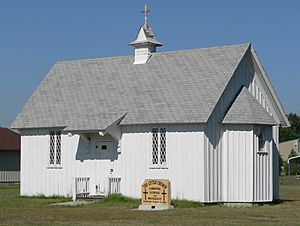
The Little Church in Keystone is listed in the National Register of Historic Places
|
|
| Country | United States |
| State | Nebraska |
| County | Keith |
| Area | |
| • Total | 0.20 sq mi (0.52 km2) |
| • Land | 0.20 sq mi (0.52 km2) |
| • Water | 0.00 sq mi (0.00 km2) |
| Elevation | 3,101 ft (945 m) |
| Population
(2020)
|
|
| • Total | 73 |
| • Density | 363.18/sq mi (140.57/km2) |
| Time zone | UTC-6 (Mountain (MST)) |
| • Summer (DST) | UTC-5 (MDT) |
| ZIP code |
69144
|
| FIPS code | 31-25335 |
| GNIS feature ID | 2583884 |
Keystone is a small community in Keith County, Nebraska, United States. It is called a census-designated place, which means it's a special area the government counts for population. In 2020, about 73 people lived there.
Keystone is located near the North Platte River. It is about 13 miles (21 km) northeast of Ogallala. Ogallala is the main town and county seat for Keith County. Keystone sits about 3,100 feet (945 meters) above sea level. Even though it's a small community, Keystone has its own post office with the ZIP code 69144.
Contents
History of Keystone, Nebraska
Keystone began to grow after the Union Pacific Railroad was built through the area. The railroad helped connect places and bring more people.
The Little Church at Keystone
Keystone is home to a special building called the Little Church at Keystone. It was designed by Thomas Rogers Kimball and built in 1908. The community was too small for two separate churches. So, local people worked together to raise money, even holding bake sales.
The church was built to be used by different groups. It has a Catholic altar at one end and a Protestant lectern at the other. The church also has special pews (church benches) that can be flipped around. This unique design allowed both Catholic and Protestant services to be held there.
Population and Demographics
Demographics is the study of a population. It looks at things like how many people live in a place. It also looks at their ages, genders, and other facts.
| Historical population | |||
|---|---|---|---|
| Census | Pop. | %± | |
| 2020 | 73 | — | |
| U.S. Decennial Census | |||
Climate in Keystone
Keystone has a type of weather called a humid subtropical climate. This means it usually has hot, humid summers and mild winters.
Temperature Records
The hottest temperature ever recorded in Keystone was 111 °F (44 °C). This happened on July 20, 1939, and again on July 11, 1954. The coldest temperature recorded was -25 °F (-32 °C) on December 22, 1989.
| Climate data for Kingsley Dam, Nebraska, 1991–2020 normals, extremes 1938–present | |||||||||||||
|---|---|---|---|---|---|---|---|---|---|---|---|---|---|
| Month | Jan | Feb | Mar | Apr | May | Jun | Jul | Aug | Sep | Oct | Nov | Dec | Year |
| Record high °F (°C) | 70 (21) |
79 (26) |
87 (31) |
94 (34) |
101 (38) |
107 (42) |
111 (44) |
106 (41) |
103 (39) |
96 (36) |
83 (28) |
77 (25) |
111 (44) |
| Mean maximum °F (°C) | 58.8 (14.9) |
64.6 (18.1) |
75.7 (24.3) |
83.7 (28.7) |
91.3 (32.9) |
97.3 (36.3) |
101.0 (38.3) |
98.3 (36.8) |
95.4 (35.2) |
85.4 (29.7) |
71.9 (22.2) |
61.1 (16.2) |
101.8 (38.8) |
| Mean daily maximum °F (°C) | 36.3 (2.4) |
39.6 (4.2) |
50.8 (10.4) |
58.9 (14.9) |
69.0 (20.6) |
80.7 (27.1) |
87.0 (30.6) |
84.8 (29.3) |
76.7 (24.8) |
62.0 (16.7) |
48.6 (9.2) |
38.3 (3.5) |
61.1 (16.1) |
| Daily mean °F (°C) | 27.0 (−2.8) |
29.3 (−1.5) |
39.2 (4.0) |
47.6 (8.7) |
58.0 (14.4) |
68.9 (20.5) |
74.9 (23.8) |
72.9 (22.7) |
64.3 (17.9) |
50.6 (10.3) |
38.5 (3.6) |
29.3 (−1.5) |
50.0 (10.0) |
| Mean daily minimum °F (°C) | 17.7 (−7.9) |
19.1 (−7.2) |
27.6 (−2.4) |
36.2 (2.3) |
47.1 (8.4) |
57.2 (14.0) |
62.8 (17.1) |
61.0 (16.1) |
51.8 (11.0) |
39.1 (3.9) |
28.4 (−2.0) |
20.3 (−6.5) |
39.0 (3.9) |
| Mean minimum °F (°C) | −1.4 (−18.6) |
0.6 (−17.4) |
10.2 (−12.1) |
22.6 (−5.2) |
34.3 (1.3) |
46.9 (8.3) |
54.2 (12.3) |
51.6 (10.9) |
38.2 (3.4) |
23.0 (−5.0) |
12.1 (−11.1) |
1.9 (−16.7) |
−8.0 (−22.2) |
| Record low °F (°C) | −2 (−19) |
−24 (−31) |
−21 (−29) |
5 (−15) |
23 (−5) |
33 (1) |
44 (7) |
43 (6) |
23 (−5) |
−1 (−18) |
−7 (−22) |
−25 (−32) |
−25 (−32) |
| Average precipitation inches (mm) | 0.33 (8.4) |
0.61 (15) |
0.92 (23) |
2.08 (53) |
3.35 (85) |
3.24 (82) |
2.84 (72) |
1.99 (51) |
1.58 (40) |
1.35 (34) |
0.51 (13) |
0.41 (10) |
19.21 (486.4) |
| Average snowfall inches (cm) | 4.0 (10) |
5.2 (13) |
3.2 (8.1) |
2.3 (5.8) |
0.2 (0.51) |
0.0 (0.0) |
0.0 (0.0) |
0.0 (0.0) |
0.0 (0.0) |
0.9 (2.3) |
2.1 (5.3) |
3.5 (8.9) |
21.4 (53.91) |
| Average precipitation days (≥ 0.01 in) | 3.2 | 5.3 | 5.5 | 7.5 | 10.9 | 10.3 | 8.4 | 7.8 | 6.1 | 6.2 | 3.6 | 3.4 | 78.2 |
| Average snowy days (≥ 0.1 in) | 2.8 | 4.3 | 2.3 | 1.4 | 0.2 | 0.0 | 0.0 | 0.0 | 0.0 | 0.5 | 2.1 | 3.0 | 16.6 |
| Source 1: NOAA | |||||||||||||
| Source 2: National Weather Service | |||||||||||||
See also
 In Spanish: Keystone (Nebraska) para niños
 | Janet Taylor Pickett |
 | Synthia Saint James |
 | Howardena Pindell |
 | Faith Ringgold |


