
Roscoe, Nebraska facts for kids
Quick facts for kids
Roscoe, Nebraska
|
|
|---|---|

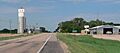
Roscoe, seen from the east along U.S. Highway 30
|
|

Roscoe, Nebraska
Location in Nebraska

Roscoe, Nebraska
Location in the United States
|
|
| Country | United States |
| State | Nebraska |
| County | Keith |
| Area | |
| • Total | 0.16 sq mi (0.41 km2) |
| • Land | 0.16 sq mi (0.41 km2) |
| • Water | 0.00 sq mi (0.00 km2) |
| Elevation | 3,176 ft (968 m) |
| Population
(2020)
|
|
| • Total | 44 |
| • Density | 280.25/sq mi (108.00/km2) |
| Time zone | UTC-7 (Central (CST)) |
| • Summer (DST) | UTC-6 (CDT) |
| ZIP Code |
69153
|
| Area code(s) | 308 |
| FIPS code | 31-42285 |
| GNIS feature ID | 2583896 |
Roscoe is a small community in Keith County, Nebraska, United States. It is known as an unincorporated community, which means it does not have its own local government like a city or town. It is also a census-designated place, which is an area the U.S. Census Bureau defines for gathering population data. In 2020, 44 people lived in Roscoe.
Contents
History of Roscoe
Roscoe began in the 1870s. This was a time when railroads were expanding across the United States. The community started to grow when the railroad tracks reached this area. Railroads were very important back then for moving people and goods.
Where is Roscoe?
Roscoe is located in the eastern part of Keith County. It sits in the valley of the South Platte River. The community is about 3,173 feet (967 meters) above sea level. This is quite high up!
Travel and Roads
U.S. Route 30 goes right through Roscoe. This highway is a main road for the area. If you go west on Route 30 for about 7 miles (11 km), you will reach Ogallala. Ogallala is the main town and county seat for Keith County. This means it's where the county government offices are.
If you travel east on Route 30 for about 12 miles (19 km), you will get to Paxton. There is also a road called Nebraska Link 51B. It goes south from Roscoe for about 1 mile (1.6 km). This road crosses the South Platte River and connects to Interstate 80, a major highway.
Size of the Area
The area defined as Roscoe by the U.S. Census Bureau is quite small. It covers about 0.41 square kilometers (0.16 square miles). All of this area is land, with no water.
Who Lives in Roscoe?
| Historical population | |||
|---|---|---|---|
| Census | Pop. | %± | |
| 2020 | 44 | — | |
| U.S. Decennial Census | |||
The study of who lives in a place is called demographics. The population of Roscoe changes over time. In 2010, there were 63 people living there. By the 2020 census, the population was 44 people. This shows that the number of residents has decreased.
Images for kids
-
Roscoe, seen from the east along U.S. Highway 30
See also
 In Spanish: Roscoe (Nebraska) para niños
