Rawlins County, Kansas facts for kids
Quick facts for kids
Rawlins County
|
|
|---|---|

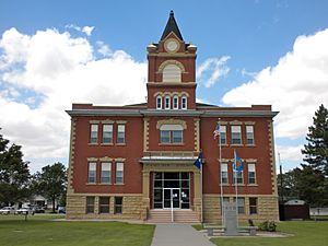
Rawlins County Courthouse in Atwood (2010)
|
|

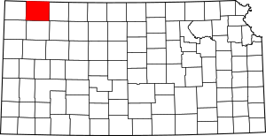
Location within the U.S. state of Kansas
|
|
 Kansas's location within the U.S. |
|
| Country | |
| State | |
| Founded | March 20, 1873 |
| Named for | John Aaron Rawlins |
| Seat | Atwood |
| Largest city | Atwood |
| Area | |
| • Total | 1,070 sq mi (2,800 km2) |
| • Land | 1,069 sq mi (2,770 km2) |
| • Water | 0.2 sq mi (0.5 km2) 0.01%% |
| Population
(2020)
|
|
| • Total | 2,561 |
| • Density | 2.4/sq mi (0.9/km2) |
| Time zone | UTC−6 (Central) |
| • Summer (DST) | UTC−5 (CDT) |
| Area code | 785 |
| Congressional district | 1st |
Rawlins County is a place in Kansas, a state in the United States. Its main town, called the county seat, is Atwood. It's also the biggest city there. In 2020, about 2,561 people lived in Rawlins County. The county is named after John Aaron Rawlins, who was a general during the American Civil War.
Contents
History of Rawlins County
Early Days and Land Ownership
For thousands of years, the Great Plains of North America were home to Native American groups. These groups often moved around to hunt and find food.
From the 1500s to the 1700s, France said it owned large parts of North America. But in 1762, after a war, France secretly gave this land to Spain. This was part of a deal called the Treaty of Fontainebleau.
Becoming Part of the United States
In 1802, Spain gave most of this land back to France. Then, in 1803, the United States bought a huge area from France. This was called the Louisiana Purchase. Most of what is now Kansas became part of the U.S. because of this purchase. The U.S. paid a very small amount for each acre of land.
Later, in 1854, the Kansas Territory was set up. Kansas officially became the 34th U.S. state in 1861. Finally, in 1873, Rawlins County was officially created.
Geography and Location
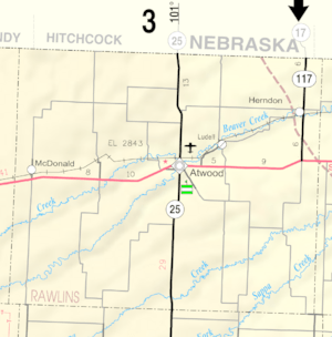
Rawlins County is located in the northwest part of Kansas. The U.S. Census Bureau says the county covers about 1,070 square miles. Almost all of this area is land, with only a tiny bit of water.
Main Roads in Rawlins County
Several important roads run through Rawlins County. These roads help people travel and transport goods across the area.
 U.S. Highway 36
 Kansas Highway 25
 Kansas Highway 117
Neighboring Counties
Rawlins County shares its borders with several other counties in Kansas and Nebraska:
- Hitchcock County, Nebraska (to the north)
- Red Willow County, Nebraska (to the northeast)
- Decatur County (to the east)
- Thomas County (to the south)
- Sherman County (to the southwest, also a time zone border)
- Cheyenne County (to the west)
- Dundy County, Nebraska (to the northwest, also a time zone border)
People and Population
The number of people living in Rawlins County has changed over time. Here's a look at the population from different years:
| Historical population | |||
|---|---|---|---|
| Census | Pop. | %± | |
| 1880 | 1,623 | — | |
| 1890 | 6,756 | 316.3% | |
| 1900 | 5,241 | −22.4% | |
| 1910 | 6,380 | 21.7% | |
| 1920 | 6,799 | 6.6% | |
| 1930 | 7,362 | 8.3% | |
| 1940 | 6,618 | −10.1% | |
| 1950 | 5,728 | −13.4% | |
| 1960 | 5,279 | −7.8% | |
| 1970 | 4,393 | −16.8% | |
| 1980 | 4,105 | −6.6% | |
| 1990 | 3,404 | −17.1% | |
| 2000 | 2,966 | −12.9% | |
| 2010 | 2,519 | −15.1% | |
| 2020 | 2,561 | 1.7% | |
| 2023 (est.) | 2,463 | −2.2% | |
| U.S. Decennial Census 1790-1960 1900-1990 1990-2000 2010-2020 |
|||
In 2000, there were about 2,966 people living in Rawlins County. Most people in the county were White (98.52%). A small number of people were Black, Native American, or Asian. Some people were also of Hispanic or Latino background.
About 27.5% of households had children under 18 living with them. The average household had about 2.29 people. The median age in the county was 45 years old. This means half the people were younger than 45, and half were older.
Education in Rawlins County
The schools in Rawlins County are part of a single school district. This district helps make sure students get a good education.
- Rawlins County USD 105
Towns and Communities
Rawlins County has several towns and communities. Some are official cities, while others are smaller, unincorporated places. There are also some "ghost towns" that used to be active but are now empty.
Cities in Rawlins County
Unincorporated Communities
These are smaller communities that are not officially organized as cities.
- Blakeman
- Ludell (This is also a Census-Designated Place, meaning the Census Bureau tracks its population.)
Ghost Towns
These places were once towns but are now mostly abandoned.
Townships
Rawlins County is divided into ten smaller areas called townships. These townships help organize the county. The populations listed below include the people living in any cities within that township.
| Township | Population | Land area km2 (sq mi) |
Water area km2 (sq mi) |
Water % | Geographic coordinates |
|---|---|---|---|---|---|
| Achilles | 83 | 132 (51) | 0 (0) | 0.02% | 39°42′13″N 100°48′38″W / 39.70361°N 100.81056°W |
| Atwood | 1,330 | 18 (7) | 0 (0) | 0.88% | 39°48′38″N 101°2′34″W / 39.81056°N 101.04278°W |
| Center | 363 | 690 (266) | 0 (0) | 0% | 39°43′11″N 101°3′56″W / 39.71972°N 101.06556°W |
| Driftwood | 84 | 185 (72) | 0 (0) | 0% | 39°57′56″N 101°4′59″W / 39.96556°N 101.08306°W |
| Herl | 386 | 491 (190) | 0 (0) | 0% | 39°49′24″N 100°49′54″W / 39.82333°N 100.83167°W |
| Jefferson | 34 | 124 (48) | 0 (0) | 0.04% | 39°36′42″N 100°48′31″W / 39.61167°N 100.80861°W |
| Ludell | 136 | 92 (35) | 0 (0) | 0.01% | 39°51′30″N 100°57′1″W / 39.85833°N 100.95028°W |
| Mirage | 43 | 185 (71) | 0 (0) | 0% | 39°38′53″N 101°14′2″W / 39.64806°N 101.23389°W |
| Rocewood | 448 | 742 (287) | 0 (0) | 0% | 39°48′17″N 101°18′59″W / 39.80472°N 101.31639°W |
| Union | 59 | 111 (43) | 0 (0) | 0% | 39°46′51″N 100°53′55″W / 39.78083°N 100.89861°W |
See also
 In Spanish: Condado de Rawlins para niños
 | Emma Amos |
 | Edward Mitchell Bannister |
 | Larry D. Alexander |
 | Ernie Barnes |


