
Sherman County, Kansas facts for kids
Quick facts for kids
Sherman County
|
|
|---|---|

Sherman County Courthouse in Goodland (2012)
|
|

Location within the U.S. state of Kansas
|
|
 Kansas's location within the U.S. |
|
| Country | |
| State | |
| Founded | September 20, 1886 |
| Named for | William Tecumseh Sherman |
| Seat | Goodland |
| Largest city | Goodland |
| Area | |
| • Total | 1,056 sq mi (2,740 km2) |
| • Land | 1,056 sq mi (2,740 km2) |
| • Water | 0.2 sq mi (0.5 km2) 0.02% |
| Population
(2020)
|
|
| • Total | 5,927 |
| • Density | 5.6/sq mi (2.2/km2) |
| Time zone | UTC−7 (Mountain) |
| • Summer (DST) | UTC−6 (MDT) |
| Congressional district | 1st |
Sherman County is a county located in the western part of Kansas, a state in the United States. Its main town and government center is Goodland. In 2020, about 5,927 people lived here. Sherman County was created in 1886. It was named after William Tecumseh Sherman, a famous general from the American Civil War.
Contents
History of Sherman County
Early Days and Land Ownership
For thousands of years, the wide-open lands of the Great Plains were home to nomadic Native American tribes. They moved around, following animals like bison.
From the 1500s to the 1700s, the Kingdom of France claimed much of North America, including this area. In 1762, after a big war, France secretly gave this land to Spain.
Becoming Part of the United States
In 1802, Spain returned most of the land to France. Then, in 1803, the United States bought a huge area from France. This was called the Louisiana Purchase. It included most of what is now Kansas. The U.S. paid a very small amount for each acre.
In 1854, the area became the Kansas Territory. Kansas officially became the 34th U.S. state in 1861. Finally, in 1886, Sherman County was officially formed.
Geography and Location
Where is Sherman County?
Sherman County covers a total area of about 1,056 square miles. Almost all of this is land, with only a tiny bit of water.
It's one of only four counties in Kansas that uses Mountain Time. This means that when it's 7 PM in most of Kansas, it's 6 PM in Sherman County. This can sometimes make TV shows air at different times!
Neighboring Counties
Sherman County shares its borders with several other counties:
- Cheyenne County (to the north)
- Rawlins County (to the northeast)
- Thomas County (to the east)
- Logan County (to the southeast)
- Wallace County (to the south)
- Kit Carson County, Colorado (to the west)
Main Roads in Sherman County
Several important highways run through Sherman County, making it easy to travel:
 Interstate 70
 US-24
US-24 K-27
K-27
People and Population

The number of people living in Sherman County has changed over the years.
| Historical population | |||
|---|---|---|---|
| Census | Pop. | %± | |
| 1880 | 13 | — | |
| 1890 | 5,261 | 40,369.2% | |
| 1900 | 3,341 | −36.5% | |
| 1910 | 4,549 | 36.2% | |
| 1920 | 5,592 | 22.9% | |
| 1930 | 7,400 | 32.3% | |
| 1940 | 6,421 | −13.2% | |
| 1950 | 7,373 | 14.8% | |
| 1960 | 6,682 | −9.4% | |
| 1970 | 7,792 | 16.6% | |
| 1980 | 7,759 | −0.4% | |
| 1990 | 6,926 | −10.7% | |
| 2000 | 6,760 | −2.4% | |
| 2010 | 6,010 | −11.1% | |
| 2020 | 5,927 | −1.4% | |
| 2023 (est.) | 5,844 | −2.8% | |
| U.S. Decennial Census 1790-1960 1900-1990 1990-2000 2010-2020 |
|||
In 2000, there were 6,760 people living in the county. About 2,758 households and 1,781 families made their homes there. The county had about 6 people per square mile.
Most people in the county were White (93.83%). A smaller number were Hispanic or Latino (8.45%).
About 29.20% of households had children under 18 living with them. Many families were married couples living together (55.80%). The average household had 2.40 people.
The population was spread out by age. About 24.60% were under 18. The median age was 38 years old. This means half the people were younger than 38 and half were older.
The average income for a household in the county was $32,684. For families, it was $38,824. About 12.90% of all people in the county lived below the poverty line. This included 16.90% of those under 18.
Education in Sherman County
Colleges and Higher Learning
- Northwest Kansas Technical College is located in Sherman County. It offers training for different jobs.
Local School Districts
Students in Sherman County attend schools in these districts:
- Brewster USD 314
- Goodland USD 352
Communities in Sherman County

Sherman County has several towns and smaller communities.
- A community marked with † is a Census-Designated Place (CDP). This means the U.S. Census Bureau counts it as a specific area, even if it's not an official city.
Cities in Sherman County
Smaller Communities (Unincorporated)
These places are not officially cities but are still communities where people live:
Townships
Sherman County is divided into thirteen smaller areas called townships. The city of Goodland is separate from these townships for population counting.
| Township | FIPS | Population center |
Population | Population density /km2 (/sq mi) |
Land area km2 (sq mi) |
Water area km2 (sq mi) |
Water % | Geographic coordinates |
|---|---|---|---|---|---|---|---|---|
| Grant | 28150 | 115 | 0 (1) | 355 (137) | 0 (0) | 0.02% | 39°28′26″N 101°54′41″W / 39.47389°N 101.91139°W | |
| Iowa | 34450 | 44 | 0 (0) | 279 (108) | 0 (0) | 0% | 39°15′27″N 101°29′38″W / 39.25750°N 101.49389°W | |
| Itasca | 34600 | 321 | 4 (10) | 87 (34) | 0 (0) | 0% | 39°19′33″N 101°40′29″W / 39.32583°N 101.67472°W | |
| Lincoln | 41175 | 95 | 1 (1) | 186 (72) | 0 (0) | 0.03% | 39°19′5″N 101°53′3″W / 39.31806°N 101.88417°W | |
| Llanos | 41650 | 43 | 0 (1) | 185 (71) | 0 (0) | 0% | 39°28′31″N 101°28′29″W / 39.47528°N 101.47472°W | |
| Logan | 42250 | 246 | 2 (5) | 138 (53) | 0 (0) | 0% | 39°19′15″N 101°46′55″W / 39.32083°N 101.78194°W | |
| McPherson | 44025 | 52 | 0 (1) | 174 (67) | 0 (0) | 0% | 39°10′18″N 101°56′12″W / 39.17167°N 101.93667°W | |
| Shermanville | 65175 | 51 | 0 (1) | 185 (71) | 0 (0) | 0% | 39°29′54″N 101°34′25″W / 39.49833°N 101.57361°W | |
| Smoky | 65950 | 87 | 0 (1) | 280 (108) | 0 (0) | 0.12% | 39°11′48″N 101°46′11″W / 39.19667°N 101.76972°W | |
| Stateline | 68150 | Kanorado | 344 | 2 (5) | 165 (64) | 0 (0) | 0.03% | 39°19′6″N 102°0′17″W / 39.31833°N 102.00472°W |
| Union | 72425 | 56 | 0 (1) | 140 (54) | 0 (0) | 0% | 39°20′25″N 101°27′24″W / 39.34028°N 101.45667°W | |
| Voltaire | 74175 | 252 | 1 (2) | 411 (159) | 0 (0) | 0% | 39°27′12″N 101°43′4″W / 39.45333°N 101.71778°W | |
| Washington | 75750 | 106 | 1 (2) | 139 (54) | 0 (0) | 0% | 39°20′0″N 101°32′59″W / 39.33333°N 101.54972°W |
Images for kids
-
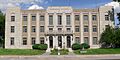
Sherman County Courthouse in Goodland (2012)
-
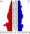
Population pyramid based on 2000 census age data
-
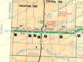
2005 map of Sherman County
See also
 In Spanish: Condado de Sherman (Kansas) para niños
