
Thomas County, Kansas facts for kids
Quick facts for kids
Thomas County
|
|
|---|---|

Thomas County Courthouse in Colby (2014)
|
|

Location within the U.S. state of Kansas
|
|
 Kansas's location within the U.S. |
|
| Country | |
| State | |
| Founded | October 8, 1885 |
| Named for | George Henry Thomas |
| Seat | Colby |
| Largest city | Colby |
| Area | |
| • Total | 1,075 sq mi (2,780 km2) |
| • Land | 1,075 sq mi (2,780 km2) |
| • Water | 0.1 sq mi (0.3 km2) 0.01% |
| Population
(2020)
|
|
| • Total | 7,930 |
| • Density | 7.4/sq mi (2.9/km2) |
| Time zone | UTC−6 (Central) |
| • Summer (DST) | UTC−5 (CDT) |
| Congressional district | 1st |
Thomas County is a special area, also called a county, located in the state of Kansas in the United States. The main town and center of its government is Colby.
In 2020, about 7,930 people lived in Thomas County. The county was named after George Henry Thomas, a brave general who fought during the American Civil War.
Contents
Exploring Thomas County's Past
How Thomas County Began
For thousands of years, the wide-open Great Plains of North America were home to nomadic Native American tribes. They moved around to hunt and find food.
Later, from the 1500s to the 1700s, the Kingdom of France claimed a huge amount of land in North America. After a big conflict called the French and Indian War in 1762, France secretly gave a large area, known as New France, to Spain. This was part of a deal called the Treaty of Fontainebleau.
The 1800s: A New Era
In 1802, Spain gave most of this land back to France. However, Spain kept about 7,500 square miles for itself. Then, in 1803, the United States bought most of the land that is now Kansas from France. This huge purchase, called the Louisiana Purchase, covered 828,000 square miles. It cost only about 2.83 cents for each acre!
In 1854, the Kansas Territory was officially set up. Then, in 1861, Kansas became the 34th U.S. state. Thomas County was officially created on October 8, 1885. It was named after George Henry Thomas, a Union general who was a hero in the American Civil War at the Battle of Chickamauga. Many of the smaller areas within the county, called townships, were named after soldiers who died in that battle.
Thomas County's Location and Landscape
Thomas County covers a total area of about 1,075 square miles. Almost all of this area is land, with only a tiny bit (0.1 square miles) being water.
Main Roads in Thomas County
These are the important highways that run through Thomas County:
 Interstate 70
 U.S. Highway 24
 U.S. Highway 83
 Kansas Highway 25
Neighboring Counties
Thomas County shares its borders with these other counties:
- Rawlins County (to the north)
- Decatur County (to the northeast)
- Sheridan County (to the east)
- Gove County (to the southeast)
- Logan County (to the south)
- Sherman County (to the west, which is also where the time zone changes)
Who Lives in Thomas County?

The number of people living in Thomas County has changed over the years:
- 1880: 161 people
- 1890: 5,538 people
- 1900: 4,112 people
- 1910: 5,455 people
- 1920: 5,517 people
- 1930: 7,334 people
- 1940: 6,425 people
- 1950: 7,572 people
- 1960: 7,358 people
- 1970: 7,501 people
- 1980: 8,451 people
- 1990: 8,258 people
- 2000: 8,180 people
- 2010: 7,900 people
- 2020: 7,930 people
As of the census in 2000, there were 8,180 people living in the county. Most people (97.14%) were White. About 1.85% of the population identified as Hispanic or Latino.
The population was spread out by age. About 26.30% of people were under 18 years old. The average age in the county was 35 years.
Learning and Education
Colleges in Thomas County
- Colby Community College is a place where students can continue their education after high school.
Local School Districts
These are the school districts that serve students in Thomas County:
- Brewster USD 314
- Colby USD 315
- Golden Plains USD 316
Towns and Communities

Here is a list of the cities, small communities, and even former towns in Thomas County.
- A "‡" means part of the community is in another county.
- A "†" means the community is a Census-Designated Place (CDP), which is a special area defined by the Census Bureau.
Cities in Thomas County
Unincorporated Communities
These are smaller communities that are not officially organized as cities:
Ghost Towns
These are places that used to be towns but are now abandoned:
- Copeland
- Cumberland
- Kuka
- Otterbourne
- Quickville
Townships of Thomas County
Thomas County is divided into thirteen smaller areas called townships. Each township was named to honor soldiers who died in the Battle of Chickamauga. The city of Colby is separate from these townships for government purposes.
| Township | Population | Land area sq mi |
|---|---|---|
| Barrett | 124 | 107 |
| East Hale | 137 | 54 |
| Kingery | 93 | 144 |
| Lacey | 132 | 36 |
| Menlo | 112 | 54 |
| Morgan | 755 | 105 |
| North Randall | 107 | 53 |
| Rovohl | 143 | 107 |
| Smith | 213 | 36 |
| South Randall | 267 | 108 |
| Summers | 197 | 144 |
| Wendell | 84 | 71 |
| West Hale | 366 | 54 |
Images for kids
-
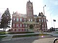
Thomas County Courthouse in Colby (2014)
-
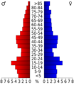
This chart shows the age groups of people in Thomas County based on the 2000 census.
-
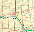
This map from 2005 shows the different areas of Thomas County.
See also
 In Spanish: Condado de Thomas (Kansas) para niños
