
Sheridan County, Kansas facts for kids
Quick facts for kids
Sheridan County
|
|
|---|---|
.jpg)
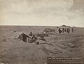
Buffalo Hunters' Home in Sheridan (1873)
|
|

Location within the U.S. state of Kansas
|
|
 Kansas's location within the U.S. |
|
| Country | |
| State | |
| Founded | 1873 |
| Named for | Philip Sheridan |
| Seat | Hoxie |
| Largest city | Hoxie |
| Area | |
| • Total | 896 sq mi (2,320 km2) |
| • Land | 896 sq mi (2,320 km2) |
| • Water | 0.3 sq mi (0.8 km2) 0.03% |
| Population
(2020)
|
|
| • Total | 2,447 |
| • Density | 2.7/sq mi (1.0/km2) |
| Time zone | UTC−6 (Central) |
| • Summer (DST) | UTC−5 (CDT) |
| Congressional district | 1st |
Sheridan County is a county in Kansas, a state in the United States. The main town, or county seat, is Hoxie. In 2020, about 2,447 people lived here. The county is named after Philip Sheridan, a famous general from the American Civil War.
Contents
Sheridan County's Past: A Look at Its History
Early Times in Kansas
For thousands of years, the Great Plains of North America were home to nomadic Native American tribes. These groups moved around, following animals and seasons.
In the 16th to 18th centuries, France claimed large parts of North America. After a war in 1762, France secretly gave its land, called New France, to Spain. This was part of a deal known as the Treaty of Fontainebleau.
The 1800s: How Kansas Grew
In 1802, Spain gave most of the land back to France. Then, in 1803, the United States bought a huge area from France. This was the Louisiana Purchase, which cost about 2.83 cents per acre. Much of what is now Kansas was part of this big purchase.
In 1854, the Kansas Territory was created. Kansas officially became the 34th U.S. state in 1861.
Sheridan County's Beginnings
In 1873, the western part of Kansas was divided into 22 new counties, and Sheridan County was one of them. The county officially started in 1880. Its first county seat was a town called Kenneth.
However, in 1886, a new railroad line was planned. It would go south of Kenneth, to a new town called Hoxie. The people of Kenneth decided to move. They were offered new land in Hoxie and help to move their buildings. So, the county seat was moved to Hoxie. The railroad line opened in 1888 and later became part of the Union Pacific Railroad.
The 1900s: Changes and Challenges
The number of people living in Sheridan County grew in the early 1900s. It reached its highest point in 1930, with 6,038 residents. Since then, the population has slowly decreased. This is a common trend in many parts of the Great Plains.
The railroad line in Sheridan County continued to operate until 1998. After floods in 1993 damaged the line, the railroad decided it was too expensive to fix. The entire line through the county was closed by 1998.
Where is Sheridan County? Geography and Neighbors

Sheridan County covers about 896 square miles (2,320 km2). Almost all of this area is land. Only a tiny bit, about 0.3 square miles (0.78 km2), is water.
Neighboring Counties
Sheridan County shares its borders with several other counties:
- To the north: Decatur County
- To the northeast: Norton County
- To the east: Graham County
- To the south: Gove County
- To the west: Thomas County
Who Lives in Sheridan County? Population Facts

| Historical population | |||
|---|---|---|---|
| Census | Pop. | %± | |
| 1880 | 1,567 | — | |
| 1890 | 3,733 | 138.2% | |
| 1900 | 3,819 | 2.3% | |
| 1910 | 5,651 | 48.0% | |
| 1920 | 5,484 | −3.0% | |
| 1930 | 6,038 | 10.1% | |
| 1940 | 5,312 | −12.0% | |
| 1950 | 4,607 | −13.3% | |
| 1960 | 4,267 | −7.4% | |
| 1970 | 3,859 | −9.6% | |
| 1980 | 3,544 | −8.2% | |
| 1990 | 3,043 | −14.1% | |
| 2000 | 2,813 | −7.6% | |
| 2010 | 2,556 | −9.1% | |
| 2020 | 2,447 | −4.3% | |
| 2023 (est.) | 2,423 | −5.2% | |
| U.S. Decennial Census 1790-1960 1900-1990 1990-2000 2010-2020 |
|||
In 2000, there were 2,813 people living in Sheridan County. They lived in 1,124 households, and 795 of these were families. The county had about 3 people per square mile.
Most people in the county were White (98.65%). A small number of people were from other racial groups. About 1.46% of the population were Hispanic or Latino.
About 30.40% of households had children under 18. Most households (63.80%) were married couples living together. The average household had 2.46 people.
The population was spread out by age. About 26.30% were under 18. About 20.30% were 65 or older. The average age was 42 years old.
The median income for a household was $33,547. For families, it was $38,292. About 15.70% of the population lived below the poverty line. This included 27.30% of those under 18.
Learning in Sheridan County: Schools
School Districts
- Hoxie USD 412 is the main school district serving the area.
Communities in Sheridan County

Sheridan County has several cities, small towns, and even some places that used to be towns but are now empty.
Cities
Unincorporated Communities
These are small communities that are not officially cities.
Ghost Towns
These are places where towns once existed but are now abandoned.
- Adell
- Alcyone
- Chicago
- Lucerne
- Museum
- Mystic
- Phelps
- Sheridan
- Ute
- Violenta
Townships
Sheridan County is divided into fourteen areas called townships. The population numbers for these townships include any cities or communities within them.
| Township | Population center |
Population | Land area sq mi |
Geographic coordinates |
|---|---|---|---|---|
| Adell | 13 | 54 | 39°30′58″N 100°14′13″W / 39.51611°N 100.23694°W | |
| Bloomfield | 45 | 36 | 39°26′8″N 100°39′52″W / 39.43556°N 100.66444°W | |
| Bowcreek | 54 | 72 | 39°25′48″N 100°17′2″W / 39.43000°N 100.28389°W | |
| East Saline | 66 | 72 | 39°11′50″N 100°12′38″W / 39.19722°N 100.21056°W | |
| Kenneth | Hoxie | 1,430 | 36 | 39°21′16″N 100°26′24″W / 39.35444°N 100.44000°W |
| Logan | 115 | 72 | 39°21′26″N 100°37′4″W / 39.35722°N 100.61778°W | |
| Parnell | 104 | 71 | 39°25′33″N 100°30′57″W / 39.42583°N 100.51583°W | |
| Prairie Dog | 71 | 36 | 39°31′27″N 100°40′15″W / 39.52417°N 100.67083°W | |
| Sheridan | 269 | 53 | 39°31′40″N 100°32′38″W / 39.52778°N 100.54389°W | |
| Solomon | 248 | 108 | 39°13′54″N 100°38′0″W / 39.23167°N 100.63333°W | |
| Springbrook | 108 | 108 | 39°13′38″N 100°28′15″W / 39.22722°N 100.47083°W | |
| Union | 60 | 36 | 39°31′52″N 100°22′35″W / 39.53111°N 100.37639°W | |
| Valley | 139 | 72 | 39°21′0″N 100°16′5″W / 39.35000°N 100.26806°W | |
| West Saline | 91 | 72 | 39°12′44″N 100°20′28″W / 39.21222°N 100.34111°W |
Images for kids
-
Buffalo Hunters' Home in Sheridan (1873)
See also
 In Spanish: Condado de Sheridan (Kansas) para niños
