Studley, Kansas facts for kids
Quick facts for kids
Studley, Kansas
|
|
|---|---|

|
|
| Country | United States |
| State | Kansas |
| County | Sheridan |
| Named for | Studley Royal Park |
| Elevation | 2,408 ft (734 m) |
| Time zone | UTC-6 (CST) |
| • Summer (DST) | UTC-5 (CDT) |
| Area code | 785 |
| FIPS code | 20-68700 |
| GNIS ID | 471292 |
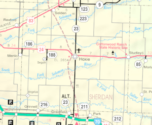
Studley is a small, unincorporated community in Sheridan County, Kansas, United States. It's located about 16 miles east of Hoxie along U.S. Route 24. This community sits on the eastern edge of Sheridan County, right next to Graham County. It was named after the beautiful Studley Royal Park in England.
Contents
Studley's Early Days
The history of Studley began in 1888 when the Lincoln-Colorado Railway, which later became part of the Union Pacific Railroad, built a station here. This new train line helped the community grow.
How Studley Got Its Name
An immigrant from England named Abraham Pratt is often seen as the founder of Studley. He built his Cottonwood Ranch just west of the small town. Because of Pratt's English background, the community was named after Studley Royal Park in England.
Post Office and Growth
A post office opened in Studley in 1889. Before 1894, this post office was known as Skelton. The post office served the community for many years until it closed in 1994.
Changes Over Time
In 1910, Studley had a population of 75 people. However, like many small towns in western Kansas, its population has become smaller over time. In the early 21st century, only about 33 people lived there.
Community Services Closing
The local grade school in Studley closed in the 1960s. This happened as part of a state plan to combine smaller schools into larger unified school districts. The last grocery store in the community also closed its doors in the 1970s.
Railroad's Departure
The Union Pacific Railroad line that passed through Studley was 99 miles long, connecting Plainville to Colby. This important railway was no longer used in 1998.
Education for Studley Students
Today, children living in Studley attend public schools that are part of the Hoxie USD 412 school district.
 | Laphonza Butler |
 | Daisy Bates |
 | Elizabeth Piper Ensley |


