
Colby, Kansas facts for kids
Quick facts for kids
Colby, Kansas
|
|
|---|---|
|
City and County seat
|
|

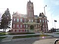
Thomas County Courthouse (2014)
|
|

Location within Thomas County and Kansas
|
|

|
|
| Country | United States |
| State | Kansas |
| County | Thomas |
| Founded | 1885 |
| Incorporated | 1886 |
| Named for | J.R. Colby |
| Area | |
| • Total | 3.58 sq mi (9.27 km2) |
| • Land | 3.58 sq mi (9.27 km2) |
| • Water | 0.00 sq mi (0.00 km2) |
| Elevation | 3,166 ft (965 m) |
| Population
(2020)
|
|
| • Total | 5,570 |
| • Density | 1,556/sq mi (600.9/km2) |
| Time zone | UTC-6 (CST) |
| • Summer (DST) | UTC-5 (CDT) |
| ZIP code |
67701
|
| Area code | 785 |
| FIPS code | 20-14650 |
| GNIS ID | 485557 |
Colby is a city in Kansas, United States. It is also the county seat of Thomas County. This means it's the main town where the county government offices are located. In 2020, about 5,570 people lived in Colby.
Contents
History of Colby
Colby started as a small settlement in 1882 when a post office was set up. Early settlers, called homesteaders, often lived in simple homes made of sod (grass and dirt). They needed a town to get supplies like wood.
A local land assessor and preacher named J.R. Colby helped create the town. In 1885, land was bought for the town site. Soon after, Colby officially became a town. The governor of Kansas named Colby the county seat that same year. In 1886, it became an incorporated city, meaning it had its own local government.
Transportation was important for Colby's growth. The Union Pacific Railroad arrived in 1887, and the Rock Island Railroad followed in 1888. These railroads helped bring people and goods to the city.
In 1941, St. Thomas Hospital was built. This was part of a big plan to build hospitals across the country. More recently, this historic hospital building was turned into apartments. In 1965, Interstate 70 reached Colby. This major highway helped the city grow, especially its hotels and restaurants.
Where is Colby? (Geography)
Colby is located in northwestern Kansas. It sits in a flat area called the High Plains, which is part of the larger Great Plains. A small stream called Prairie Dog Creek flows nearby.
Colby is easy to find because it's right where two major roads meet: Interstate 70 and K-25. It's about 212 miles (341 km) east-southeast of Denver and 232 miles (373 km) northwest of Wichita. The city covers about 3.38 square miles (8.75 square kilometers) of land.
Colby's Climate
Colby has a climate that changes between two types: a humid continental climate and a semiarid climate. This means it has hot summers and cold, dry winters. The hottest temperature ever recorded in Colby was 113°F (45°C) in July 1940 and June 2012. The coldest temperature recorded was -32°F (-36°C) in December 1989.
People of Colby (Demographics)
| Historical population | |||
|---|---|---|---|
| Census | Pop. | %± | |
| 1890 | 516 | — | |
| 1900 | 641 | 24.2% | |
| 1910 | 1,130 | 76.3% | |
| 1920 | 1,114 | −1.4% | |
| 1930 | 2,153 | 93.3% | |
| 1940 | 2,458 | 14.2% | |
| 1950 | 3,859 | 57.0% | |
| 1960 | 4,210 | 9.1% | |
| 1970 | 4,658 | 10.6% | |
| 1980 | 5,544 | 19.0% | |
| 1990 | 5,396 | −2.7% | |
| 2000 | 5,450 | 1.0% | |
| 2010 | 5,387 | −1.2% | |
| 2020 | 5,570 | 3.4% | |
| U.S. Decennial Census 2010-2020 |
|||
2020 Census Information
In 2020, Colby had 5,570 people living there. There were about 2,199 households. Many different groups of people live in Colby. Most residents are white, but there are also African American, Native American, Asian, and people of two or more races. About 8% of the population is Hispanic or Latino.
About 23% of the people in Colby were under 18 years old. The average age in the city was about 34.6 years.
Learning in Colby (Education)
Colby offers several options for education, from college to elementary school.
Colleges and Universities
- Colby Community College is a local college where students can continue their education after high school.
Schools for Kids
The public schools in Colby are part of the Colby USD 315 school district. They include:
- Colby High School (for grades 9-12)
- Colby Middle School (for grades 5-8)
- Colby Grade School (for grades K-4)
- Thomas County Academy (a charter school for grades 5-9)
There are also two private schools:
- Sacred Heart Catholic School (for Pre-K to grade 5)
- Heartland Christian School (for grades K-12)
Getting Around (Transportation)
Colby is well-connected by roads and has its own airport.
- Interstate 70 runs just south of the city.
- U.S. Route 24 goes through the city from east to west.
- K-25 runs north to south, crossing U.S. Route 24.
The Colby Municipal Airport is located a short distance north of the city. For trains, the Kyle Railroad runs through Colby, and a Union Pacific Railroad line also reaches the city.
News and Entertainment (Media)
Colby has its own local newspaper, the Colby Free Press, which comes out four days a week. Students at Colby Community College also publish their own newspaper called the Trojan Express.
You can also find local radio and TV stations in Colby. Two television stations broadcast from the city: KLBY (an ABC affiliate) and KWKS (a public television station).
Fun Places to Visit (Points of Interest)
Colby has many interesting places to explore!
- The Prairie Museum of Art and History is a great place to learn about the history of Thomas County. It's a large museum with 24 acres of exhibits. One of its most famous features is the Cooper Barn, known as the "Largest Barn in Kansas."
- The Thomas County Courthouse is a historic building built in 1907. It's listed on the National Register of Historic Places. Other historic buildings in Colby include the old Colby Community High School and the Colby City Hall.
- Villa High Lake is a city-made lake located in Villa High Park. The park is a fun spot with playground equipment, picnic areas, and disc golf. You can also go fishing there.
- Fike Park is another park in Colby with gazebos, volleyball, horseshoe pits, and tennis courts. In the early 2000s, new playground equipment was added, making it even better for kids.
- The Pioneer Memorial Library is a public library where you can find books and learn.
- The Colby Aquatic Park, opened in 2012, is perfect for hot days! It has a lazy river, a lap pool, and exciting water slides.
- The Colby Event Center, which opened in 2021, is a big indoor facility. It has two gyms, meeting rooms, and an indoor playground. It's where Colby High School and Colby Community College play their basketball and volleyball games.
Famous People from Colby (Notable People)
Many interesting people have connections to Colby, Kansas. Here are a few:
|
|
Images for kids
-
Thomas County Courthouse (2014)
-

Location within Thomas County and Kansas
-
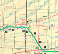
KDOT map of Thomas County (legend)
See also
 In Spanish: Colby (Kansas) para niños
