
Decatur County, Kansas facts for kids
Quick facts for kids
Decatur County
|
|
|---|---|

Bank of Oberlin (2014)
|
|

Location within the U.S. state of Kansas
|
|
 Kansas's location within the U.S. |
|
| Country | |
| State | |
| Founded | March 20, 1873 |
| Named for | Stephen Decatur, Jr. |
| Seat | Oberlin |
| Largest city | Oberlin |
| Area | |
| • Total | 894 sq mi (2,320 km2) |
| • Land | 894 sq mi (2,320 km2) |
| • Water | 0.6 sq mi (2 km2) 0.07%% |
| Population
(2020)
|
|
| • Total | 2,764 |
| • Density | 3.1/sq mi (1.2/km2) |
| Time zone | UTC−6 (Central) |
| • Summer (DST) | UTC−5 (CDT) |
| Area code | 785 |
| Congressional district | 1st |
Decatur County is a special area called a county in Northwest Kansas. It's like a district with its own local government. The main town and biggest city in the county is Oberlin. In 2020, about 2,764 people lived here.
The county got its name from Stephen Decatur, Jr.. He was a brave officer in the United States Navy. He served in important wars like the Barbary Wars and the War of 1812.
Contents
History of Decatur County
Early Times
For thousands of years, the wide-open Great Plains of North America were home to nomadic Native American tribes. They moved around to hunt and find food.
In the 16th to 18th centuries, the Kingdom of France said they owned large parts of North America. But after a war in 1762, France secretly gave a huge area, called New France, to Spain. This was part of a deal called the Treaty of Fontainebleau.
The 1800s
In 1802, Spain gave most of this land back to France. Then, in 1803, the United States bought a massive amount of land from France. This was called the Louisiana Purchase. It included most of what is now Kansas. The U.S. paid a very small amount for each acre of land.
In 1854, the Kansas Territory was set up. Then, in 1861, Kansas officially became the 34th state in the U.S.
Decatur County was created on March 20, 1873. It was officially organized on December 15, 1879. As mentioned, it was named after the Navy hero Commodore Stephen Decatur, Jr..
Oberlin was also the location of the last Native American raid in Kansas. This event involved the Northern Cheyenne tribe.
Geography

Decatur County covers about 894 square miles. Almost all of this area is land. Only a tiny part, about 0.6 square miles, is water.
Neighboring Counties
Decatur County shares its borders with several other counties:
- Red Willow County, Nebraska (to the north)
- Furnas County, Nebraska (to the northeast)
- Norton County (to the east)
- Sheridan County (to the south)
- Thomas County (to the southwest)
- Rawlins County (to the west)
Population Information

| Historical population | |||
|---|---|---|---|
| Census | Pop. | %± | |
| 1880 | 4,180 | — | |
| 1890 | 8,414 | 101.3% | |
| 1900 | 9,234 | 9.7% | |
| 1910 | 8,976 | −2.8% | |
| 1920 | 8,121 | −9.5% | |
| 1930 | 8,866 | 9.2% | |
| 1940 | 7,434 | −16.2% | |
| 1950 | 6,185 | −16.8% | |
| 1960 | 5,778 | −6.6% | |
| 1970 | 4,988 | −13.7% | |
| 1980 | 4,509 | −9.6% | |
| 1990 | 4,021 | −10.8% | |
| 2000 | 3,472 | −13.7% | |
| 2010 | 2,961 | −14.7% | |
| 2020 | 2,764 | −6.7% | |
| 2023 (est.) | 2,712 | −8.4% | |
| U.S. Decennial Census 1790-1960 1900-1990 1990-2000 2010-2020 |
|||
In 1879, about 1,500 people lived in Decatur County. By 1886, this number grew to 6,300. The population reached its highest point around 1900, with over 9,200 people. Since then, the population has slowly decreased. In 2020, there were 2,764 residents.
In 2000, there were 3,472 people living in the county. Most residents were White. About 25.8% of households had children under 18. The average age of people in the county was 44 years old.
Education
In 1909, Decatur County had 101 different school districts. Today, there is one main school district:
- Oberlin USD 294
Towns and Places
Cities
These are the main cities in Decatur County:
Unincorporated Places
These are smaller communities that are not officially cities:
- Allison
- Cedar Bluffs
- Kanona
- Leoville
- Lyle
- Traer
Townships
Decatur County is divided into twenty-five smaller areas called townships. The city of Oberlin is separate and not included in the township numbers. Each township has its own local government.
Images for kids
-
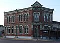
Bank of Oberlin (2014)
-

Population pyramid based on 2000 census age data
-
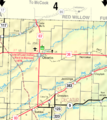
2005 KDOT Map of Decatur County (map legend)
See also
 In Spanish: Condado de Decatur (Kansas) para niños
