
Cheyenne County, Kansas facts for kids
Quick facts for kids
Cheyenne County
|
|
|---|---|

Cheyenne County Courthouse in St. Francis (2010)
|
|

Location within the U.S. state of Kansas
|
|
 Kansas's location within the U.S. |
|
| Country | |
| State | |
| Founded | March 20, 1873 |
| Named for | Cheyenne tribe |
| Seat | St. Francis |
| Largest city | St. Francis |
| Area | |
| • Total | 1,021 sq mi (2,640 km2) |
| • Land | 1,020 sq mi (2,600 km2) |
| • Water | 1.1 sq mi (3 km2) 0.1%% |
| Population
(2020)
|
|
| • Total | 2,616 |
| • Density | 2.6/sq mi (1.0/km2) |
| Time zone | UTC−6 (Central) |
| • Summer (DST) | UTC−5 (CDT) |
| Area code | 785 |
| Congressional district | 1st |
Cheyenne County is a county located in the northwest part of the U.S. state of Kansas. The main town and county seat (where the county government is) is St. Francis. In 2020, about 2,616 people lived in the county. It was named after the Cheyenne tribe.
Contents
History of Cheyenne County
How Cheyenne County Started
In 1854, the area became the Kansas Territory. Then, in 1861, Kansas officially became the 34th U.S. state.
Cheyenne County was created by the state government on March 6, 1873. The first people to settle there arrived in 1879.
Early Settlements and Life
Many early settlers made their homes near a place called Wano. The first cattle ranch in the county, called the "T" ranch, was set up about 9 miles (14 km) from Wano in 1876. Families like Jacob Buck, A. M. Brenaman, and L. R. Heaton also settled in the area.
A. M. Brenaman became the first postmaster for the Wano post office, which opened on August 23, 1880. The first store opened the next month. The first school building, which taught 10 students, was donated by F. J. Graham and opened on January 10, 1882. By 1886, there were 5 school districts in the county.
The name Wano came from the Spanish word "bueno", which means "good". Wano was also the name of the county's first newspaper, the Wano News, also run by Brenaman.
Choosing the County Seat
Cheyenne County officially started its own government in April 1886. At first, the governor chose Bird City as the temporary county seat.
Later, an election was held in May 1886 to pick a permanent county seat. Wano was chosen, but this election was found to have problems and was canceled. Finally, in February 1889, the town of St. Francis was chosen as the county seat in another election. This choice was approved by the state government in February 1891.
Geography of Cheyenne County
The U.S. Census Bureau says that Cheyenne County covers about 1,021 square miles (2,644 km²). Most of this area, about 1,020 square miles (2,642 km²), is land. Only a small part, about 1.1 square miles (2.8 km²), is water.
Farming and Nature
In 1886, about 6,890 acres (2,788 ha) of the county were fenced farms, and 68,807 acres (27,845 ha) were unfenced farmland. This made up about 12% of the county's total land.
Farmers grew crops like corn and sorghum. Corn was the most valuable crop at the time. However, most farmers raised livestock (animals like cattle). By 1910, the main crops were wheat, corn, barley, hay, and broomcorn. There were not many natural forests or woodlands in the county.
Rivers and Soil
The Republican River flows through Cheyenne County. Smaller streams like Bluff Creek, Cherry Creek, Plum Creek, and Hackberry Creek flow into it. Other rivers include Little Beaver Creek and a small part of Big Beaver Creek in the southeast. The Arickaree River is in the northwest.
The soil in the county is mostly sandy. Some streams have small amounts of limestone.
Neighboring Counties
Cheyenne County shares borders with several other counties:
- Dundy County, Nebraska (to the north)
- Rawlins County (to the east)
- Sherman County (to the south)
- Kit Carson County, Colorado (to the southwest)
- Yuma County, Colorado (to the west)
Main Roads
- U.S. Route 36
- Kansas Highway 27
- Kansas Highway 161
Time Zones
Cheyenne County is in the Central Time Zone. However, it is unique because it is bordered by the Mountain Time Zone on three sides! Dundy County, Nebraska to the north, Yuma County, Colorado and Kit Carson County, Colorado to the west, and Sherman County to the south are all in the Mountain Time Zone. This means Rawlins County is Cheyenne County's only neighbor that also uses Central Time.
Population and People

| Historical population | |||
|---|---|---|---|
| Census | Pop. | %± | |
| 1880 | 37 | — | |
| 1890 | 4,401 | 11,794.6% | |
| 1900 | 2,640 | −40.0% | |
| 1910 | 4,248 | 60.9% | |
| 1920 | 5,587 | 31.5% | |
| 1930 | 6,948 | 24.4% | |
| 1940 | 6,221 | −10.5% | |
| 1950 | 5,668 | −8.9% | |
| 1960 | 4,708 | −16.9% | |
| 1970 | 4,256 | −9.6% | |
| 1980 | 3,678 | −13.6% | |
| 1990 | 3,243 | −11.8% | |
| 2000 | 3,165 | −2.4% | |
| 2010 | 2,726 | −13.9% | |
| 2020 | 2,616 | −4.0% | |
| 2023 (est.) | 2,636 | −3.3% | |
| U.S. Decennial Census 1790–1960 1900–1990 1990–2000 2010–2020 |
|||
In 1886, there were 2,607 people living in Cheyenne County. By 1910, this number had grown to 4,248.
According to the 2000 census, there were 3,165 people in the county. Most people (97.91%) were White. About 2.59% of the population were Hispanic or Latino.
The population was spread out across different age groups. About 23.80% were under 18 years old, and 26.60% were 65 years or older. The average age was 44 years.
The average income for a household in the county was $30,599. About 9.40% of the population lived below the poverty line.
Education in Cheyenne County
Cheyenne County has two main school districts:
- Cheylin USD 103
- St. Francis Schools USD 297
Communities in Cheyenne County

Here are the main towns and areas in Cheyenne County:
Cities
- Bird City
- St. Francis (the county seat)
Unincorporated Community
- Wheeler (a community that is not officially a city)
Ghost Town
- Marney (a former community that is now abandoned)
Post Offices Through Time
In 1886, there were six post offices: Bird City, Calhoun, Lawnridge, Marney, Orlando, and Wano. By 1888, four more had been added, and Wano had changed its name to St. Francis. By 1910, only four remained: Bird City, Jaqua, St. Francis, and Wheeler.
Townships
Cheyenne County is divided into seven areas called townships. The populations of the cities are included in their township totals.
| Township | FIPS | Population center |
Population | Population density /km2 (/sq mi) |
Land area km2 (sq mi) |
Water area km2 (sq mi) |
Water % | Geographic coordinates |
|---|---|---|---|---|---|---|---|---|
| Benkelman | 06025 | 57 | 0 (1) | 186 (72) | 0 (0) | 0% | 39°37′8″N 101°54′35″W / 39.61889°N 101.90972°W | |
| Bird City | 06850 | Bird City | 771 | 1 (2) | 884 (341) | 0 (0) | 0.02% | 39°45′30″N 101°31′41″W / 39.75833°N 101.52806°W |
| Calhoun | 09950 | 57 | 0 (1) | 231 (89) | 2 (1) | 0.70% | 39°56′8″N 101°39′18″W / 39.93556°N 101.65500°W | |
| Cleveland Run | 14150 | 67 | 0 (1) | 186 (72) | 0 (0) | 0.08% | 39°52′35″N 101°48′20″W / 39.87639°N 101.80556°W | |
| Jaqua | 35025 | 46 | 0 (1) | 124 (48) | 0 (0) | 0.01% | 39°39′48″N 102°1′20″W / 39.66333°N 102.02222°W | |
| Orlando | 53050 | 63 | 1 (2) | 93 (36) | 0 (0) | 0% | 39°45′36″N 101°41′0″W / 39.76000°N 101.68333°W | |
| Wano | 75375 | St. Francis | 2,104 | 2 (6) | 937 (362) | 0 (0) | 0.05% | 39°45′27″N 101°50′4″W / 39.75750°N 101.83444°W |
| Sources: | ||||||||
When it first started in 1883, Cheyenne County was a single township connected to Rawlins County for legal and money matters. Over time, the number of townships changed, with some being added and others combined, especially in the 1970s.
Images for kids
-
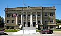
Cheyenne County Courthouse in St. Francis (2010)
-
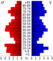
Population pyramid based on 2000 census age data
-
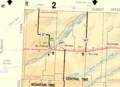
2005 map of Cheyenne County (map legend)
See also
 In Spanish: Condado de Cheyenne (Kansas) para niños
