Yuma County, Colorado facts for kids
Quick facts for kids
Yuma County
|
|
|---|---|

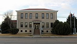
The Yuma County Court-House in Wray.
|
|

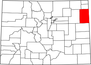
Location within the U.S. state of Colorado
|
|
 Colorado's location within the U.S. |
|
| Country | |
| State | |
| Founded | March 15, 1889 |
| Seat | Wray |
| Largest city | Yuma |
| Area | |
| • Total | 2,369 sq mi (6,140 km2) |
| • Land | 2,364 sq mi (6,120 km2) |
| • Water | 4.3 sq mi (11 km2) 0.2%% |
| Population
(2020)
|
|
| • Total | 9,988 |
| • Density | 4.2/sq mi (1.6/km2) |
| Time zone | UTC−7 (Mountain) |
| • Summer (DST) | UTC−6 (MDT) |
| Congressional district | 4th |
Yuma County is a county located in the state of Colorado, USA. As of the 2020 census, about 9,988 people lived there. The main town and county seat is Wray.
Contents
Exploring Yuma County's Geography
Yuma County covers a total area of about 2,369 square miles. Most of this area, 2,364 square miles, is land. Only a small part, about 4.3 square miles, is water.
Colorado's Lowest Point in Yuma County
A special fact about Yuma County is that it holds the lowest point in all of Colorado. This spot is where the Arikaree River flows out of Yuma County and into Cheyenne County, Kansas. The elevation here is 1,010 meters (3,314 feet) above sea level. This makes it the highest "lowest point" of any state in the United States.
Neighboring Areas: Counties Around Yuma
Yuma County shares its borders with several other counties. Knowing these helps you understand its location.
- Phillips County (to the north)
- Chase County, Nebraska (to the northeast)
- Dundy County, Nebraska (to the east)
- Cheyenne County, Kansas (to the east, also a time zone border)
- Kit Carson County (to the south)
- Washington County (to the west)
- Logan County (to the northwest)
Main Roads: Highways in Yuma County
Several important highways pass through Yuma County. These roads connect the county to other parts of Colorado and neighboring states.
Understanding Yuma County's Population Changes
The number of people living in Yuma County has changed over many years. This information comes from the United States Census, which counts the population every ten years.
| Historical population | |||
|---|---|---|---|
| Census | Pop. | %± | |
| 1890 | 2,596 | — | |
| 1900 | 1,729 | −33.4% | |
| 1910 | 8,499 | 391.6% | |
| 1920 | 13,897 | 63.5% | |
| 1930 | 13,613 | −2.0% | |
| 1940 | 12,102 | −11.1% | |
| 1950 | 10,827 | −10.5% | |
| 1960 | 8,912 | −17.7% | |
| 1970 | 8,544 | −4.1% | |
| 1980 | 9,682 | 13.3% | |
| 1990 | 8,954 | −7.5% | |
| 2000 | 9,841 | 9.9% | |
| 2010 | 10,043 | 2.1% | |
| 2020 | 9,988 | −0.5% | |
| 2023 (est.) | 9,862 | −1.8% | |
| U.S. Decennial Census 1790-1960 1900-1990 1990-2000 2010-2020 |
|||
In 2000, there were 9,841 people living in Yuma County. These people lived in 3,800 households. About 33% of these households had children under 18 living with them. The average age of people in the county was 37 years old.
Towns and Cities in Yuma County
Yuma County is home to several communities, from busy cities to smaller towns and even places that are no longer inhabited.
Cities to Visit
Small Towns to Explore
Other Populated Places
These are areas where people live, but they are not officially organized as cities or towns.
Unincorporated Communities
These are small settlements that are not part of any city or town.
Ghost Towns: Echoes of the Past
Yuma County also has many ghost towns. These were once active communities that are now mostly abandoned. They tell stories of the past.
- Arlene
- Armel
- Arnold
- Avoca
- Beecher
- Bolton
- Bryant
- Condon
- Ford
- Fox
- Friend
- Gurney
- Happyville
- Heartstrong
- Hermes
- Hughes
- Ladlum
- Lansing
- Leslie
- Logan
- Mildred
- Newton
- Robb
- Rogers
- Schramm
- Shields
- Steffens
- Wages
- Waverly
- Weld City
- Witherbee
Images for kids
See also
 In Spanish: Condado de Yuma (Colorado) para niños
 | James Van Der Zee |
 | Alma Thomas |
 | Ellis Wilson |
 | Margaret Taylor-Burroughs |


