
Yuma, Colorado facts for kids
Quick facts for kids
Yuma, Colorado
|
|
|---|---|

Aerial view of Yuma (2022)
|
|

Location within Yuma County and Colorado
|
|
| Country | United States |
| State | Colorado |
| County | Yuma |
| Incorporated | March 24, 1887 |
| Named for | Yuma |
| Area | |
| • Total | 3.14 sq mi (8.13 km2) |
| • Land | 3.10 sq mi (8.03 km2) |
| • Water | 0.04 sq mi (0.10 km2) |
| Elevation | 4,137 ft (1,261 m) |
| Population
(2020)
|
|
| • Total | 3,456 |
| • Density | 1,100.6/sq mi (425.1/km2) |
| Time zone | UTC−7 (MST) |
| • Summer (DST) | UTC−6 (MDT) |
| ZIP Code |
80759
|
| Area code | 970 |
| FIPS code | 08-86750 |
| GNIS ID | 202920 |
Yuma is a town in Colorado, United States. It is the biggest town in Yuma County. In 2020, about 3,456 people lived there. Yuma is a "home rule municipality," which means it has the power to make its own local laws.
Contents
Yuma's Story: A Look Back
Yuma has had a post office since 1885. This means people could send and receive mail there a long time ago! The town got its name from a Native American person named Yuma. This person worked for the railroad and was buried near where the town is now.
In August 2023, a tornado touched down close to Yuma. It caused some damage to farms in the area. The sports teams at Yuma School are known as the Outlaws.
Where is Yuma?
Yuma is located in Colorado. According to the United States Census Bureau, the city covers about 3.14 square miles (8.13 square kilometers). Most of this area is land, with a small part being water. Yuma is about 27 miles away from the city of Wray.
Yuma's Weather: What's it Like?
Yuma has a climate with warm summers and cold winters. You can see more details about the temperatures and rainfall below.
| Climate data for Yuma, Colorado (1991–2020 normals, extremes 1900–1902, 1939–present) | |||||||||||||
|---|---|---|---|---|---|---|---|---|---|---|---|---|---|
| Month | Jan | Feb | Mar | Apr | May | Jun | Jul | Aug | Sep | Oct | Nov | Dec | Year |
| Record high °F (°C) | 77 (25) |
82 (28) |
89 (32) |
93 (34) |
100 (38) |
111 (44) |
109 (43) |
111 (44) |
103 (39) |
94 (34) |
90 (32) |
77 (25) |
111 (44) |
| Mean daily maximum °F (°C) | 42.6 (5.9) |
45.2 (7.3) |
56.2 (13.4) |
63.3 (17.4) |
73.2 (22.9) |
85.8 (29.9) |
91.8 (33.2) |
88.9 (31.6) |
80.6 (27.0) |
66.3 (19.1) |
53.2 (11.8) |
42.9 (6.1) |
65.8 (18.8) |
| Daily mean °F (°C) | 29.9 (−1.2) |
32.0 (0.0) |
41.7 (5.4) |
48.9 (9.4) |
59.5 (15.3) |
71.1 (21.7) |
76.9 (24.9) |
74.3 (23.5) |
65.4 (18.6) |
51.6 (10.9) |
39.6 (4.2) |
30.2 (−1.0) |
51.8 (11.0) |
| Mean daily minimum °F (°C) | 17.2 (−8.2) |
18.8 (−7.3) |
27.1 (−2.7) |
34.5 (1.4) |
45.8 (7.7) |
56.4 (13.6) |
62.1 (16.7) |
59.7 (15.4) |
50.2 (10.1) |
36.9 (2.7) |
26.0 (−3.3) |
17.6 (−8.0) |
37.7 (3.2) |
| Record low °F (°C) | −28 (−33) |
−27 (−33) |
−22 (−30) |
4 (−16) |
11 (−12) |
29 (−2) |
37 (3) |
35 (2) |
14 (−10) |
3 (−16) |
−14 (−26) |
−33 (−36) |
−33 (−36) |
| Average precipitation inches (mm) | 0.29 (7.4) |
0.44 (11) |
0.81 (21) |
1.64 (42) |
2.94 (75) |
2.49 (63) |
3.07 (78) |
2.64 (67) |
1.44 (37) |
1.25 (32) |
0.50 (13) |
0.45 (11) |
17.96 (456) |
| Average snowfall inches (cm) | 3.9 (9.9) |
3.1 (7.9) |
3.7 (9.4) |
1.9 (4.8) |
0.1 (0.25) |
0.0 (0.0) |
0.0 (0.0) |
0.0 (0.0) |
0.2 (0.51) |
1.4 (3.6) |
2.8 (7.1) |
5.7 (14) |
22.8 (58) |
| Average precipitation days (≥ 0.01 in) | 2.2 | 2.9 | 3.0 | 6.8 | 9.4 | 7.9 | 9.1 | 8.6 | 4.8 | 4.7 | 2.6 | 2.6 | 64.6 |
| Average snowy days (≥ 0.1 in) | 1.9 | 2.3 | 1.3 | 0.9 | 0.1 | 0.0 | 0.0 | 0.0 | 0.0 | 0.5 | 1.3 | 2.2 | 10.5 |
| Source: NOAA | |||||||||||||
Who Lives in Yuma?
"Demographics" is a word that describes the people who live in a place. It includes things like how many people there are and how the population has changed over time. The population of Yuma has changed quite a bit since 1890. Here's a look at how many people have lived in Yuma over the years:
| Historical population | |||
|---|---|---|---|
| Census | Pop. | %± | |
| 1890 | 241 | — | |
| 1900 | 139 | −42.3% | |
| 1910 | 333 | 139.6% | |
| 1920 | 1,177 | 253.5% | |
| 1930 | 1,360 | 15.5% | |
| 1940 | 1,606 | 18.1% | |
| 1950 | 1,908 | 18.8% | |
| 1960 | 1,919 | 0.6% | |
| 1970 | 2,259 | 17.7% | |
| 1980 | 2,824 | 25.0% | |
| 1990 | 2,719 | −3.7% | |
| 2000 | 3,285 | 20.8% | |
| 2010 | 3,524 | 7.3% | |
| 2020 | 3,456 | −1.9% | |
Pictures of Yuma
-
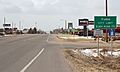
Yuma seen from the east
-
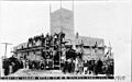
Postcard: Laying the cornerstone of the Methodist Episcopal Church, 1910


See also
 In Spanish: Yuma (Colorado) para niños
