Wray, Colorado facts for kids
Quick facts for kids
Wray, Colorado
|
|||
|---|---|---|---|

Wray (2004)
|
|||
|
|||

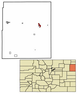
Location within Yuma County and Colorado
|
|||
| Country | United States | ||
| State | Colorado | ||
| County | Yuma | ||
| Incorporated | June 22, 1906 | ||
| Named for | John Wray | ||
| Area | |||
| • Total | 3.52 sq mi (9.10 km2) | ||
| • Land | 3.51 sq mi (9.10 km2) | ||
| • Water | 0.00 sq mi (0.01 km2) | ||
| Elevation | 3,563 ft (1,086 m) | ||
| Population
(2020)
|
|||
| • Total | 2,358 | ||
| • Density | 669.9/sq mi (259.12/km2) | ||
| Time zone | UTC−7 (MST) | ||
| • Summer (DST) | UTC−6 (MDT) | ||
| ZIP Code |
80758
|
||
| Area code | 970 | ||
| FIPS code | 08-86310 | ||
| GNIS ID | 183032 | ||
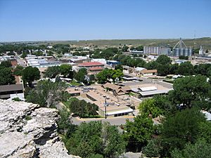
Wray (pronounced "ray") is a town in Colorado, United States. It is the main town, or county seat, of Yuma County. In 2020, about 2,358 people lived there. Wray is located in the northeast part of Colorado, about 9 miles from the Nebraska state line, in an area called the Colorado Plains.
Contents
History of Wray
A post office opened in Wray in 1882. The town was named after John Wray, who was a cattle rancher.
In 1993, Wray was given a special award. It was named an "All-America City" by the National Civic League. This award recognizes communities where people work together to solve problems and make their city a better place.
Geography and Climate
Wray is located at 40°4′36″N 102°13′33″W / 40.07667°N 102.22583°W. It is near where two major roads, U.S. Highway 34 and U.S. Highway 385, cross. The city covers about 3.0 square miles (7.8 square kilometers) of land.
Wray's Climate
Wray has a semi-arid continental climate. This means it usually has dry weather, with hot summers and cold winters.
| Climate data for Wray, Colorado (1991–2020 normals, extremes 1893–present) | |||||||||||||
|---|---|---|---|---|---|---|---|---|---|---|---|---|---|
| Month | Jan | Feb | Mar | Apr | May | Jun | Jul | Aug | Sep | Oct | Nov | Dec | Year |
| Record high °F (°C) | 80 (27) |
80 (27) |
88 (31) |
94 (34) |
103 (39) |
110 (43) |
112 (44) |
110 (43) |
105 (41) |
96 (36) |
90 (32) |
78 (26) |
112 (44) |
| Mean daily maximum °F (°C) | 43.2 (6.2) |
45.8 (7.7) |
56.3 (13.5) |
64.0 (17.8) |
73.2 (22.9) |
84.9 (29.4) |
90.7 (32.6) |
88.2 (31.2) |
80.7 (27.1) |
67.2 (19.6) |
54.0 (12.2) |
43.8 (6.6) |
66.0 (18.9) |
| Daily mean °F (°C) | 29.3 (−1.5) |
31.8 (−0.1) |
41.0 (5.0) |
48.7 (9.3) |
59.0 (15.0) |
70.2 (21.2) |
75.9 (24.4) |
73.4 (23.0) |
64.8 (18.2) |
51.2 (10.7) |
39.1 (3.9) |
30.0 (−1.1) |
51.2 (10.7) |
| Mean daily minimum °F (°C) | 15.5 (−9.2) |
17.7 (−7.9) |
25.7 (−3.5) |
33.4 (0.8) |
44.8 (7.1) |
55.5 (13.1) |
61.1 (16.2) |
58.7 (14.8) |
48.8 (9.3) |
35.1 (1.7) |
24.2 (−4.3) |
16.1 (−8.8) |
36.4 (2.4) |
| Record low °F (°C) | −28 (−33) |
−32 (−36) |
−24 (−31) |
−5 (−21) |
10 (−12) |
25 (−4) |
39 (4) |
34 (1) |
18 (−8) |
0 (−18) |
−15 (−26) |
−33 (−36) |
−33 (−36) |
| Average precipitation inches (mm) | 0.43 (11) |
0.59 (15) |
0.80 (20) |
1.88 (48) |
2.88 (73) |
2.33 (59) |
3.43 (87) |
2.47 (63) |
1.22 (31) |
1.37 (35) |
0.59 (15) |
0.40 (10) |
18.39 (467) |
| Average snowfall inches (cm) | 5.0 (13) |
6.2 (16) |
4.4 (11) |
2.4 (6.1) |
0.3 (0.76) |
0.0 (0.0) |
0.0 (0.0) |
0.0 (0.0) |
0.2 (0.51) |
1.9 (4.8) |
3.3 (8.4) |
4.4 (11) |
28.1 (71) |
| Average precipitation days (≥ 0.01 in) | 2.9 | 3.7 | 4.4 | 7.0 | 10.2 | 8.7 | 9.6 | 7.9 | 5.5 | 5.2 | 3.5 | 3.5 | 72.1 |
| Average snowy days (≥ 0.1 in) | 2.4 | 3.1 | 2.5 | 1.3 | 0.1 | 0.0 | 0.0 | 0.0 | 0.1 | 0.8 | 1.8 | 2.7 | 14.8 |
| Source: NOAA | |||||||||||||
Population Changes
The population of Wray has changed over the years. Here's how many people have lived there during different census counts:
| Historical population | |||
|---|---|---|---|
| Census | Pop. | %± | |
| 1890 | 125 | — | |
| 1900 | 271 | 116.8% | |
| 1910 | 1,000 | 269.0% | |
| 1920 | 1,538 | 53.8% | |
| 1930 | 1,785 | 16.1% | |
| 1940 | 2,061 | 15.5% | |
| 1950 | 2,198 | 6.6% | |
| 1960 | 2,082 | −5.3% | |
| 1970 | 1,953 | −6.2% | |
| 1980 | 2,131 | 9.1% | |
| 1990 | 1,998 | −6.2% | |
| 2000 | 2,187 | 9.5% | |
| 2010 | 2,342 | 7.1% | |
| 2020 | 2,358 | 0.7% | |
Education in Wray
The students in Wray are known as the Eagles for high school sports teams. Younger students in lower grades are called Eaglets. The school colors are purple and white. The Eaglets used to have blue and white colors, but they changed to purple and white in 2011 to match the high school. The school building was recently updated. Now, all students from kindergarten through 12th grade attend classes at the same location.
Healthcare Services
The town of Wray and the areas around it are served by the Wray Community District Hospital. This hospital is special because it is one of the few hospitals in the Eastern Plains of Colorado that offers care for pregnant mothers and new babies (Obstetric Care).
Notable People from Wray
- Harold Tabor (1897-1977) - He was a politician, meaning he was involved in government and making laws.
See also
 In Spanish: Wray (Colorado) para niños
 | Selma Burke |
 | Pauline Powell Burns |
 | Frederick J. Brown |
 | Robert Blackburn |


