Joes, Colorado facts for kids
Quick facts for kids
Joes, Colorado
|
|
|---|---|

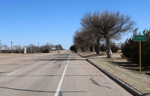
Joes, looking east on U.S. Route 36.
|
|

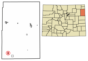
Location of the Joes CDP in Yuma County, Colorado.
|
|
| Country | |
| State | |
| County | Yuma County |
| Government | |
| • Type | unincorporated town |
| Area | |
| • Total | 2.088 sq mi (5.408 km2) |
| • Land | 2.085 sq mi (5.401 km2) |
| • Water | 0.003 sq mi (0.007 km2) |
| Elevation | 4,275 ft (1,303 m) |
| Population
(2020)
|
|
| • Total | 82 |
| • Density | 39.27/sq mi (15.16/km2) |
| Time zone | UTC-7 (MST) |
| • Summer (DST) | UTC-6 (MDT) |
| ZIP Code |
80822
|
| Area code(s) | 970 |
| GNIS feature | Joes CDP |
Joes is a small community in Yuma County, Colorado, in the United States. It's called a "census-designated place" (CDP). This means it's an area that the government counts for population, but it's not an official town or city. Joes has its own post office with the ZIP Code 80822.
In 2020, a government count called the United States Census 2020 showed that 82 people lived in the Joes CDP.
Contents
History of Joes
The Joes post office first opened its doors in 1912. The community got its name because many of the first people who settled there were named Joe!
Geography and Location
The Joes CDP covers an area of about 5.4 square kilometers (which is about 1,336 acres). Only a tiny part of this area is water.
Joes is also home to Liberty High School.
Climate in Joes
Joes experiences a climate with warm summers and cold winters. The temperature can change a lot between seasons.
| Climate data for Joes, Colorado (1991–2020 normals, extremes 1980–2022) | |||||||||||||
|---|---|---|---|---|---|---|---|---|---|---|---|---|---|
| Month | Jan | Feb | Mar | Apr | May | Jun | Jul | Aug | Sep | Oct | Nov | Dec | Year |
| Record high °F (°C) | 77 (25) |
81 (27) |
87 (31) |
92 (33) |
99 (37) |
111 (44) |
109 (43) |
112 (44) |
102 (39) |
94 (34) |
85 (29) |
80 (27) |
112 (44) |
| Mean daily maximum °F (°C) | 43.5 (6.4) |
45.8 (7.7) |
56.6 (13.7) |
63.9 (17.7) |
73.2 (22.9) |
84.7 (29.3) |
89.4 (31.9) |
87.5 (30.8) |
80.9 (27.2) |
67.2 (19.6) |
53.8 (12.1) |
44.1 (6.7) |
65.9 (18.8) |
| Daily mean °F (°C) | 29.4 (−1.4) |
31.9 (−0.1) |
41.4 (5.2) |
48.8 (9.3) |
58.9 (14.9) |
69.8 (21.0) |
74.8 (23.8) |
72.9 (22.7) |
64.9 (18.3) |
51.5 (10.8) |
39.3 (4.1) |
30.3 (−0.9) |
51.2 (10.7) |
| Mean daily minimum °F (°C) | 15.4 (−9.2) |
18.0 (−7.8) |
26.2 (−3.2) |
33.6 (0.9) |
44.7 (7.1) |
54.9 (12.7) |
60.1 (15.6) |
58.2 (14.6) |
49.0 (9.4) |
35.8 (2.1) |
24.7 (−4.1) |
16.4 (−8.7) |
36.4 (2.4) |
| Record low °F (°C) | −20 (−29) |
−24 (−31) |
−8 (−22) |
4 (−16) |
24 (−4) |
35 (2) |
44 (7) |
38 (3) |
19 (−7) |
−1 (−18) |
−13 (−25) |
−29 (−34) |
−29 (−34) |
| Average precipitation inches (mm) | 0.43 (11) |
0.40 (10) |
0.80 (20) |
1.80 (46) |
2.61 (66) |
2.88 (73) |
2.95 (75) |
2.22 (56) |
1.23 (31) |
1.17 (30) |
0.51 (13) |
0.51 (13) |
17.51 (445) |
| Average snowfall inches (cm) | 5.3 (13) |
3.8 (9.7) |
4.6 (12) |
3.3 (8.4) |
0.4 (1.0) |
0.0 (0.0) |
0.0 (0.0) |
0.0 (0.0) |
0.4 (1.0) |
2.4 (6.1) |
4.0 (10) |
5.8 (15) |
30.0 (76) |
| Average precipitation days (≥ 0.01 in) | 2.8 | 3.1 | 4.1 | 5.7 | 7.7 | 7.2 | 8.0 | 7.1 | 4.1 | 4.1 | 3.0 | 2.7 | 59.6 |
| Average snowy days (≥ 0.1 in) | 2.3 | 2.5 | 2.3 | 1.6 | 0.2 | 0.0 | 0.0 | 0.0 | 0.1 | 0.8 | 2.0 | 2.6 | 14.4 |
| Source: NOAA | |||||||||||||
Population and Demographics
A "census" is like a big count of all the people living in an area. The United States Census Bureau collects this information.
| Joes CDP, Colorado | ||
|---|---|---|
| Year | Pop. | ±% |
| 2010 | 80 | — |
| 2020 | 82 | +2.5% |
| Source: United States Census Bureau | ||
The Joes CDP was first officially counted for the United States Census 2010. In 2010, 80 people lived there. By 2020, the population had grown slightly to 82 people.
See also
 In Spanish: Joes (Colorado) para niños
 | Frances Mary Albrier |
 | Whitney Young |
 | Muhammad Ali |


