
Max, Nebraska facts for kids
Quick facts for kids
Max, Nebraska
|
|
|---|---|

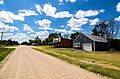
Main Street in Max, July 2017
|
|

Max, Nebraska
Location in Nebraska

Max, Nebraska
Location in the United States
|
|
| Country | United States |
| State | Nebraska |
| County | Dundy |
| Area | |
| • Total | 0.22 sq mi (0.57 km2) |
| • Land | 0.22 sq mi (0.57 km2) |
| • Water | 0.00 sq mi (0.00 km2) |
| Elevation | 2,907 ft (886 m) |
| Population
(2020)
|
|
| • Total | 50 |
| • Density | 226.24/sq mi (87.42/km2) |
| Time zone | UTC-7 (Mountain (MST)) |
| • Summer (DST) | UTC-6 (MDT) |
| ZIP code |
69037
|
| FIPS code | 31-31150 |
| GNIS feature ID | 2583891 |
Max is a small community located in Dundy County, Nebraska, in the United States. It is known as a census-designated place, which means it's an area identified by the U.S. Census Bureau for statistical purposes. In 2020, about 50 people lived in Max.
About Max, Nebraska
Max is found in the eastern part of Dundy County. It sits along U.S. Route 34, a main road that runs through the Republican River valley. From Max, it's about 9 miles southwest to Benkelman, which is the main town and county seat. If you travel east, it's about 10 miles to Stratton. Max is located high above sea level, at about 2,900 feet.
History of Max
The first people settled in the area that would become Max in 1880. The community was named after its first postmaster, a person named Max Monivisin.
Population Facts
Max is a very small community. Its population was counted during the 2020 United States Census. At that time, 50 people lived there.
| Historical population | |||
|---|---|---|---|
| Census | Pop. | %± | |
| 2020 | 50 | — | |
| U.S. Decennial Census | |||
Images for kids
-
Main Street in Max, July 2017
See also
 In Spanish: Max (Nebraska) para niños
