
Smoky Hill River facts for kids
Quick facts for kids Smoky Hill River |
|
|---|---|

Smoky Hill River near Assaria, Kansas
|
|

Map of the Smoky Hill drainage basin
|
|
| Other name(s) | Aahkawirarahkata, Chetolah, Oke-see-sebo, River of the Padoucas |
| Country | United States |
| State | Colorado, Kansas |
| Physical characteristics | |
| Main source | Cheyenne County, Colorado 4,640 ft (1,410 m) 38°57′01″N 102°34′49″W / 38.95028°N 102.58028°W |
| River mouth | Kansas River Junction City, Kansas 1,040 ft (320 m) 39°03′36″N 98°46′04″W / 39.06000°N 98.76778°W |
| Length | 575 mi (925 km) |
| Basin features | |
| Basin size | 19,260 sq mi (49,900 km2) |
| Tributaries |
|
| Watersheds | Smoky Hill-Kansas-Missouri-Mississippi |
The Smoky Hill River is a long river in the central Great Plains of North America. It flows for about 575-mile (925 km) (925 km). The river travels through the U.S. states of Colorado and Kansas.
Contents
What's in a Name?
The Smoky Hill River gets its name from the Smoky Hills area. This region is part of the Great Plains.
Where Does the River Start and End?
The Smoky Hill River begins in Cheyenne County, Colorado. It starts at an elevation of about 4,640 ft (1,410 m) (1,414 meters) above sea level.
The river flows east and eventually joins with the Republican River. When these two rivers meet, they form the Kansas River. This meeting point is near Junction City, Kansas. The elevation here is about 1,040 ft (320 m) (317 meters).
How Big is the River's Area?
The area that drains into the Smoky Hill River is called its basin. This basin covers a huge space of about 19,260 sq mi (49,900 km2) (49,883 square kilometers).
Rivers That Join the Smoky Hill
Many smaller rivers and creeks flow into the Smoky Hill River. These are called tributaries.
- Some rivers that join from the left side include:
- A river that joins from the right side is:
Images for kids
-
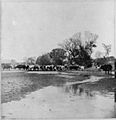
Cattle crossing the Smoky Hill River at Ellsworth (photo by A. Gardner, 1867).

See also
 In Spanish: Río Smoky Hill para niños
