Cheyenne County, Colorado facts for kids
Quick facts for kids
Cheyenne County
|
|
|---|---|

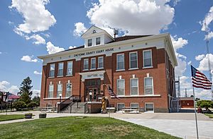
Cheyenne County Colorado Courthouse
|
|

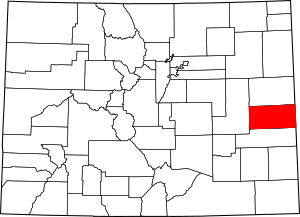
Location within the U.S. state of Colorado
|
|
 Colorado's location within the U.S. |
|
| Country | |
| State | |
| Founded | March 25, 1889 |
| Named for | The Cheyenne Nation |
| Seat | Cheyenne Wells |
| Largest town | Cheyenne Wells |
| Area | |
| • Total | 1,781 sq mi (4,610 km2) |
| • Land | 1,778 sq mi (4,600 km2) |
| • Water | 3.2 sq mi (8 km2) 0.2%% |
| Population
(2020)
|
|
| • Total | 1,748 |
| • Density | 1.0/sq mi (0.4/km2) |
| Time zone | UTC−7 (Mountain) |
| • Summer (DST) | UTC−6 (MDT) |
| Congressional district | 4th |
Cheyenne County is a county located in the eastern part of the U.S. state of Colorado. In 2020, about 1,748 people lived here. The main town and county seat is Cheyenne Wells. This county is named after the Cheyenne Indians, a Native American tribe.
Contents
History of Cheyenne County
Cheyenne County was officially created by the Colorado State Legislature on March 25, 1889. It was formed from parts of two other counties: Bent County and Elbert County. The county got its name from the Cheyenne Indians, who used to live in eastern Colorado.
Exploring Cheyenne County's Geography
According to the U.S. Census Bureau, Cheyenne County covers a total area of about 1,781 square miles. Most of this area, about 1,778 square miles, is land. Only a tiny part, about 3.2 square miles, is water.
Rivers and Creeks
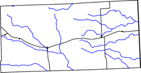
Cheyenne County has many dry creek beds that sometimes fill with water. These include Bellyache, Big Timber, and Ladder Creeks. The Smoky Hill River also flows through the county. This river eventually joins the Republican River in Kansas. Creeks in the northern and eastern parts of the county flow towards the Republican or Smoky Hill Rivers. Those in the central and southeastern parts flow towards the Arkansas River. These creeks usually only have water when snow melts or after it rains a lot.
High Points and Hills
There are four notable hills in Cheyenne County. These are Agate Mound, Eureka Hill, Landsman Hill, and Twin Buttes. The very highest point in the county is in the far northwest corner, reaching about 5,255 feet high.
Neighboring Counties
Cheyenne County shares its borders with several other counties:
- Kit Carson County to the north
- Wallace County, Kansas to the east
- Greeley County, Kansas to the southeast
- Lincoln County to the west
- Kiowa County to the south
Main Roads and Highways
Several important highways pass through Cheyenne County, making it easy to travel around. These include:
The Antipode of Île Saint-Paul
Cheyenne County is a special place because it is home to the antipode of Île Saint-Paul. An antipode is the exact opposite point on Earth. If you could dig a straight tunnel through the center of the Earth from Cheyenne County, you would come out on Île Saint-Paul, a small French island in the Indian Ocean. This makes Cheyenne County one of the few places in the main part of the United States with an antipode that is not in the ocean.
People of Cheyenne County
| Historical population | |||
|---|---|---|---|
| Census | Pop. | %± | |
| 1890 | 534 | — | |
| 1900 | 501 | −6.2% | |
| 1910 | 3,687 | 635.9% | |
| 1920 | 3,746 | 1.6% | |
| 1930 | 3,723 | −0.6% | |
| 1940 | 2,964 | −20.4% | |
| 1950 | 3,453 | 16.5% | |
| 1960 | 2,789 | −19.2% | |
| 1970 | 2,396 | −14.1% | |
| 1980 | 2,153 | −10.1% | |
| 1990 | 2,397 | 11.3% | |
| 2000 | 2,231 | −6.9% | |
| 2010 | 1,836 | −17.7% | |
| 2020 | 1,748 | −4.8% | |
| 2023 (est.) | 1,727 | −5.9% | |
| U.S. Decennial Census 1790-1960 1900-1990 1990-2000 2010-2020 |
|||
The population of Cheyenne County has changed over the years. In 1890, there were 534 people. The population grew quite a bit in the early 1900s, reaching over 3,700 by 1920. Since then, the number of people living in the county has slowly decreased. By the 2020 census, the population was 1,748 people.
In 2000, the average age of people in the county was 38 years old. About 28.8% of the population was under 18 years old.
Communities in Cheyenne County
Cheyenne County has several towns and communities where people live.
Towns
- Cheyenne Wells: This is the county seat and the largest town.
- Kit Carson: Another town in the county.
Census Designated Place
- Arapahoe: This is a community that the census bureau tracks.
Unincorporated Communities
- Wild Horse: A smaller community not officially part of a town.
Historic Trails of the Past
Many old trails crossed Cheyenne County, playing an important role in history.
- Old Military Trail: This trail connected two forts: Fort Wallace in Kansas and Fort Lyon in Colorado. It was used for military travel.
- Omaha Trail: This trail came from Kansas into the northeast part of Cheyenne County. It then joined up with the Smoky Hill Trail.
- Smoky Hill Trail: This trail was also known as the Butterfield Trail or the Starvation Trail. It followed the Smoky Hill River from east to west across Cheyenne County. Explorers like Lt. John C. Fremont used it as early as 1844. When gold was found in Colorado in 1859, this trail became a popular route to Denver. However, it was a very difficult and dangerous path, which is why it earned the name "Starvation Trail." The Butterfield Overland Dispatch used this trail for mail and passenger service. Because the area was Native American hunting grounds, several military forts were built along the trail to keep travelers safe. The Kansas Pacific Railway later followed this trail through Kansas. The trail split into two forks near "Old Wells," which was about five miles north of today's Cheyenne Wells.
- Texas-Montana Cattle Trail: This trail was used during the Civil War to move cattle from the south to the north. It crossed Cheyenne County from south to north.
Historic Sites to Visit
Cheyenne County has several interesting historic buildings that tell stories of the past.
- Cheyenne County Courthouse in Cheyenne Wells: This beautiful building was constructed in 1908. It is listed on the National Register of Historic Places, meaning it's an important historical landmark.
- Old Cheyenne County Jail in Cheyenne Wells: Built in 1894, this jail was used until 1961. Today, it is a historical museum where you can learn about the county's past. The jail was designed by a famous Colorado architect named Robert Roeschlaub.
- The Historic Plains Hotel in Cheyenne Wells: This hotel was built in 1919 and is still used as a hotel today.
- Mountain States Telephone & Telegraph Building in Cheyenne Wells: This building was constructed in 1927. You can see the word "Telephone" on its front. It is now a museum.
- Kit Carson Pool Hall in Kit Carson: An old building in the town of Kit Carson.
- Union Pacific Pumphouse in Kit Carson: Built around 1880, this stone building was used by the Union Pacific Railroad to pump water for its steam trains.
- Wild Horse Mercantile in Wild Horse: This store was built after a fire in 1917 and operated continuously until the late 1960s.
- Wild Horse School in Wild Horse: This school building was constructed in 1912.
See also
 In Spanish: Condado de Cheyenne (Colorado) para niños
 | Leon Lynch |
 | Milton P. Webster |
 | Ferdinand Smith |


