Kiowa County, Colorado facts for kids
Quick facts for kids
Kiowa County
|
|
|---|---|

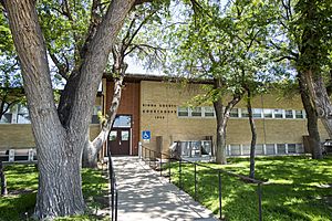
Kiowa County Courthouse
|
|

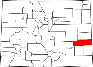
Location within the U.S. state of Colorado
|
|
 Colorado's location within the U.S. |
|
| Country | |
| State | |
| Founded | April 11, 1889 |
| Named for | Kiowa Nation |
| Seat | Eads |
| Largest town | Eads |
| Area | |
| • Total | 1,786 sq mi (4,630 km2) |
| • Land | 1,768 sq mi (4,580 km2) |
| • Water | 18 sq mi (50 km2) 1.0%% |
| Population
(2020)
|
|
| • Total | 1,446 |
| • Density | 0.8/sq mi (0.3/km2) |
| Time zone | UTC−7 (Mountain) |
| • Summer (DST) | UTC−6 (MDT) |
| Congressional district | 4th |
Kiowa County is a county in Colorado, a state in the United States. In 2020, about 1,446 people lived there. This makes it one of the least populated counties in Colorado. The main town, or county seat, is Eads. The county got its name from the Kiowa Nation, a group of Native Americans.
Contents
History of Kiowa County
The Sand Creek Massacre
On November 29, 1864, a very sad event happened in what is now Kiowa County. This was long before Colorado became a state. A group of Native Americans, mostly old men, women, and children, were attacked. This event is known as the Sand Creek Massacre.
At first, some people thought it was a victory in a conflict called the Colorado War. But later, investigations by the United States Congress showed what really happened. This caused a big national problem.
The governor at the time, John Evans, lost his job because of his part in the event. Colonel John Chivington, who led the U.S. forces, was strongly criticized by Congress.
The exact place of the massacre was not found until 1999. In 2005, the National Park Service created the Sand Creek Massacre National Historic Site. Today, visitors can go to a small center, walk on trails, and see signs and monuments that look over the site. The massacre site itself is a sacred place and is not open to visitors.
Railroads and Farming in the 1880s
In the late 1880s, many people became interested in farming in eastern Colorado. They did not know yet that farming would be hard to keep up in this dry area. At the same time, railroads were being built west across the plains. They were heading towards the gold fields in the Rocky Mountains during the Colorado Gold Rush.
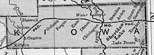
The Missouri Pacific Railroad came into what would become Kiowa County from Kansas in 1887.
Small camps were set up for railroad workers near the Kansas border. After the town of Sheridan Lake, new towns and camps were named in alphabetical order as the railroad moved west.
Towns like Arden, Brandon, Chivington, Diston, Eads, Fergus, Galatea, Haswell, Inman, Joliet, and Kilburn appeared. Some of these grew into real towns, while others did not. Chivington was planned to be a big stop for trains to get water. A large hotel was even built there. But the water was not good, so trains stopped in Kansas instead. The hotel was soon taken down, and its parts were used to build other things in Colorado. This was common when boom towns failed.
Kiowa County was officially created in 1889. It was named after the Kiowa Indians who lived in eastern Colorado before European settlers arrived. Sheridan Lake was first the county seat. It only became a railroad stop after local people built a depot. In 1902, the county seat moved to Eads.
Kiowa County Today
Farming in eastern Colorado faced big problems during the Dust Bowl in the 1930s. Today, most farms grow crops without much irrigation, and some ranching continues. Cities and farms closer to the mountains have bought most of the water rights. This means the underground water sources, called aquifers, are drying up. Kiowa County is facing less and less water and possible economic challenges.
It is possible that much of the county will eventually return to its natural state. This would be sparse grassland and prairie like it was before the 1880s.
Today, Eads is the largest town in the county. It is the county seat and serves the remaining farms and ranches. It also has the county's largest high school. Sheridan Lake still has a combined junior and senior high school. Other towns that still exist in some form include Towner, Arlington, Brandon, Chivington, and Haswell.
Eads is also home to the county's main hospital, Weisbrod Memorial County Hospital.
Geography of Kiowa County
Kiowa County covers about 1,786 square miles. Most of this is land (1,768 square miles), and a small part is water (18 square miles).
Important streams in the county include Adobe Creek and Mustang Creek in the west. Rush Creek and Big Sandy Creek are in the middle. Wildhorse, Buffalo, and White Woman creeks are in the east. These streams often dry up, but Adobe, Rush, and Big Sandy creeks can have small flows during wetter years. All these creeks eventually flow into the Arkansas River.
South of Eads, near U.S. Highway 287, are the Great Plains Reservoirs. This is a group of four large reservoirs and several smaller ones. They provide water for local farms. They also offer places for hunting, fishing, and watching wildlife in the Queens State Wildlife Area.
Neighboring Counties
- Cheyenne County - north
- Greeley County, Kansas - east
- Bent County - south
- Prowers County - south
- Otero County - southwest
- Crowley County - west
- Lincoln County - northwest
Main Roads
Protected Areas
Bicycle Routes
Population of Kiowa County
| Historical population | |||
|---|---|---|---|
| Census | Pop. | %± | |
| 1890 | 1,243 | — | |
| 1900 | 701 | −43.6% | |
| 1910 | 2,899 | 313.6% | |
| 1920 | 3,755 | 29.5% | |
| 1930 | 3,786 | 0.8% | |
| 1940 | 2,793 | −26.2% | |
| 1950 | 3,003 | 7.5% | |
| 1960 | 2,425 | −19.2% | |
| 1970 | 2,029 | −16.3% | |
| 1980 | 1,936 | −4.6% | |
| 1990 | 1,688 | −12.8% | |
| 2000 | 1,622 | −3.9% | |
| 2010 | 1,398 | −13.8% | |
| 2020 | 1,446 | 3.4% | |
| 2023 (est.) | 1,384 | −1.0% | |
| U.S. Decennial Census 1790-1960 1900-1990 1990-2000 2010-2020 |
|||
In 2020, the population of Kiowa County was 1,446 people. The population has changed a lot over the years. It grew quite a bit in the early 1900s, reaching its highest point in 1930 with 3,786 people. Since then, the population has slowly decreased.
Towns and Communities
Towns
Census-Designated Places
Other Small Places
See also
 In Spanish: Condado de Kiowa (Colorado) para niños
 | Charles R. Drew |
 | Benjamin Banneker |
 | Jane C. Wright |
 | Roger Arliner Young |


