
Crowley County, Colorado facts for kids
Quick facts for kids
Crowley County
|
|
|---|---|

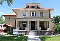
The Crowley County Justice Center in Ordway.
|
|

Location within the U.S. state of Colorado
|
|
 Colorado's location within the U.S. |
|
| Country | |
| State | |
| Founded | May 29, 1911 |
| Named for | John H. Crowley |
| Seat | Ordway |
| Largest town | Ordway |
| Area | |
| • Total | 800 sq mi (2,000 km2) |
| • Land | 787 sq mi (2,040 km2) |
| • Water | 13 sq mi (30 km2) 1.6%% |
| Population
(2020)
|
|
| • Total | 5,922 |
| • Density | 7.5/sq mi (2.9/km2) |
| Time zone | UTC−7 (Mountain) |
| • Summer (DST) | UTC−6 (MDT) |
| Congressional district | 4th |
Crowley County is a county located in the state of Colorado. In 2020, about 5,922 people lived there. The main town and county seat is Ordway.
Contents
History of Crowley County
Crowley County was created by the Colorado government on May 29, 1911. It was formed from the northern parts of Otero County. Before that, both areas were part of Bent County. The county was named after John H. Crowley. He was a senator from Otero County when the county was formed.
Long ago, Native American tribes lived here. The Cheyenne people were among the main tribes in the area.
A big change happened in 1887 when the Missouri Pacific Railroad came through. This railroad helped connect the area to Pueblo and the gold fields of Colorado. This led to more people settling in the county.
The town of Ordway was started in 1890. It quickly became the main business center for the county. Other towns that grew along the railroad route include Sugar City, Crowley, and Olney Springs.
Later, a canal was built to bring water from the Arkansas River. The goal was to water a very large area. While it didn't reach Kansas, it did irrigate about 57,000 acres (230 km2) in Crowley County. This made the county a rich farming area for a while.
By the 1970s, most of the water rights from this canal were sold. They were bought by the fast-growing cities along Colorado's Front Range. Because of this, the county's main economic activity changed. It shifted from farming to ranching. Much of the land has now returned to its natural prairie grassland state.
The Crowley School is a special historic place in the county. It is now called the Crowley County Heritage Center. It is the only site in the county listed on the U.S. National Register of Historic Places.
Today, Crowley County is also home to two correctional facilities. These are the Arkansas Valley Correctional Facility in Ordway and the Crowley County Correctional Facility in Olney Springs. These facilities have a big impact on the county's population numbers. In 2010, a large part of the county's residents lived in these facilities.
Geography of Crowley County
Crowley County covers a total area of about 800 square miles (2,072 km2). Most of this, about 787 square miles (2,038 km2), is land. The remaining 13 square miles (34 km2) is water. Lake Meredith is the biggest lake in the county. It is located south of Ordway and Sugar City.
Counties Nearby
Crowley County shares borders with several other counties:
- Lincoln County to the north
- El Paso County to the northwest
- Otero County to the south
- Kiowa County to the east
- Pueblo County to the west
Main Roads
Several important state highways pass through Crowley County:
 State Highway 71
 State Highway 96
 State Highway 167
 State Highway 207
Bicycle Trail
People of Crowley County (Demographics)
| Historical population | |||
|---|---|---|---|
| Census | Pop. | %± | |
| 1920 | 6,383 | — | |
| 1930 | 5,934 | −7.0% | |
| 1940 | 5,398 | −9.0% | |
| 1950 | 5,222 | −3.3% | |
| 1960 | 3,978 | −23.8% | |
| 1970 | 3,086 | −22.4% | |
| 1980 | 2,988 | −3.2% | |
| 1990 | 3,946 | 32.1% | |
| 2000 | 5,518 | 39.8% | |
| 2010 | 5,823 | 5.5% | |
| 2020 | 5,922 | 1.7% | |
| 2023 (est.) | 5,636 | −3.2% | |
| U.S. Decennial Census 1790-1960 1900-1990 1990-2000 2010-2020 |
|||
Based on the census from 2000, there were 5,518 people living in Crowley County. These people lived in 1,358 households, and 957 of these were families. The population density was about 7 people per square mile (3 people/km2).
The county's population included people of different backgrounds. About 83% were White, 7% were Black or African American, and 2.6% were Native American. About 22.5% of the population identified as Hispanic or Latino.
In the households, about 34.5% had children under 18 living with them. More than half, 55.1%, were married couples living together. About 25.7% of all households were made up of people living alone.
The age of the population was spread out. About 18.8% were under 18 years old. About 39.6% were between 25 and 44 years old. The median age was 37 years. It's interesting to note that there were many more males than females in the county. This is largely because a significant part of the population lives in the correctional facilities located there.
The average income for a household in the county was about $26,803. For families, the average income was about $32,162. The average income per person in the county was $12,836.
A unique feature of Crowley County's population is the presence of correctional facilities. Many people counted in the census live in these facilities. This affects the overall population numbers and demographics, including the male-to-female ratio and the racial makeup of the county.
Communities in Crowley County
Towns
Images for kids
-
The Crowley County Justice Center in Ordway.
See also
 In Spanish: Condado de Crowley para niños
