Otero County, Colorado facts for kids
Quick facts for kids
Otero County
|
|
|---|---|

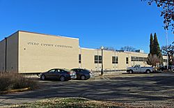
Otero County Courthouse in La Junta
|
|

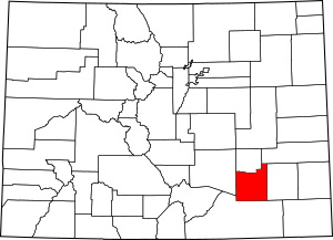
Location within the U.S. state of Colorado
|
|
 Colorado's location within the U.S. |
|
| Country | |
| State | |
| Founded | March 25, 1889 |
| Named for | Miguel Antonio Otero |
| Seat | La Junta |
| Largest city | La Junta |
| Area | |
| • Total | 1,270 sq mi (3,300 km2) |
| • Land | 1,262 sq mi (3,270 km2) |
| • Water | 7.7 sq mi (20 km2) 0.6%% |
| Population
(2020)
|
|
| • Total | 18,690 |
| • Density | 15/sq mi (6/km2) |
| Time zone | UTC−7 (Mountain) |
| • Summer (DST) | UTC−6 (MDT) |
| Congressional district | 3rd |

Otero County is a county located in the U.S. state of Colorado. It is in the southeastern part of the state. As of the 2020 census, about 18,690 people lived here. The county seat is La Junta. This is the main town where the county government offices are.
The county was named after Miguel Antonio Otero. He was one of the people who helped start the town of La Junta. Miguel Antonio Otero came from a well-known Hispanic family.
Contents
Geography of Otero County
Otero County covers a total area of about 1,270 square miles. Most of this area, about 1,262 square miles, is land. A small part, about 7.7 square miles, is water.
Neighboring Counties
Otero County shares its borders with several other counties in Colorado:
- Crowley County to the north
- Kiowa County to the northeast
- Bent County to the east
- Las Animas County to the south
- Pueblo County to the west
Main Roads and Highways
Several important roads run through Otero County, connecting its towns and cities:
 U.S. Highway 50
 U.S. Highway 350
 State Highway 10
 State Highway 71
 State Highway 109
 State Highway 167
 State Highway 207
 State Highway 266
Protected Natural Areas
Otero County is home to some special protected areas:
- Bent's Old Fort National Historic Site: This is a famous old trading post. It shows what life was like in the 1800s.
- Comanche National Grassland: A large area of protected grasslands. It is important for wildlife and nature.
- Santa Fe National Historic Trail: This historic trail passes through the county. It was a trade route in the past.
Trails and Scenic Routes
You can also find these trails and byways in Otero County:
- American Discovery Trail: A long trail that crosses the United States.
- Santa Fe Trail National Scenic Byway: A scenic road that follows the historic Santa Fe Trail.
Population and People
| Historical population | |||
|---|---|---|---|
| Census | Pop. | %± | |
| 1890 | 4,192 | — | |
| 1900 | 11,522 | 174.9% | |
| 1910 | 20,201 | 75.3% | |
| 1920 | 22,623 | 12.0% | |
| 1930 | 24,390 | 7.8% | |
| 1940 | 23,571 | −3.4% | |
| 1950 | 25,275 | 7.2% | |
| 1960 | 24,128 | −4.5% | |
| 1970 | 23,523 | −2.5% | |
| 1980 | 22,567 | −4.1% | |
| 1990 | 20,185 | −10.6% | |
| 2000 | 20,311 | 0.6% | |
| 2010 | 18,831 | −7.3% | |
| 2020 | 18,690 | −0.7% | |
| 2023 (est.) | 18,136 | −3.7% | |
| U.S. Decennial Census 1790-1960 1900-1990 1990-2000 2010-2020 |
|||
In 2000, there were 20,311 people living in Otero County. The population density was about 16 people per square mile. Many different groups of people live in the county. About 37.62% of the population were Hispanic or Latino.
Towns and Cities
Otero County has several communities, including cities and smaller towns.
Cities
Towns
Census-Designated Places
These are areas that are like towns but are not officially incorporated as cities or towns:
See also
 In Spanish: Condado de Otero (Colorado) para niños
 | Toni Morrison |
 | Barack Obama |
 | Martin Luther King Jr. |
 | Ralph Bunche |


