
Fowler, Colorado facts for kids
Quick facts for kids
Fowler, Colorado
|
|
|---|---|

Welcome Sign (2010)
|
|

Location of the Town of Fowler in Otero County, Colorado
|
|

Fowler, Colorado
Location in the United States

Fowler, Colorado
Location in Colorado
|
|
| Country | |
| State | |
| County | Otero |
| Incorporated (town) | August 25, 1925 |
| Area | |
| • Total | 0.563 sq mi (1.458 km2) |
| • Land | 0 sq mi (0.000 km2) |
| • Water | 0.559 sq mi (1.448 km2) |
| Elevation | 4,341 ft (1,323 m) |
| Population
(2020)
|
|
| • Total | 1,253 |
| • Density | 2,241/sq mi (865/km2) |
| Time zone | UTC−07:00 (MST) |
| • Summer (DST) | UTC−06:00 (MDT) |
| ZIP code |
81039
|
| Area code(s) | 719 |
| FIPS code | 08-27975 |
| GNIS ID | 204802 |
Fowler is a small town in Colorado, United States. It is located in the northwestern part of Otero County. In 2020, about 1,253 people lived in Fowler.
Contents
History of Fowler
Fowler began as a stop for the Atchison, Topeka and Santa Fe Railway train. It was first called Oxford. This name came from a large ox that died while crossing the train tracks.
The post office in Oxford opened in 1882. Later, in 1890, the town's name was changed to Fowler. It was named after Orson Squire Fowler, who helped start the town. Fowler officially became an incorporated town on August 25, 1900.
Geography of Fowler
Fowler is located near the Arkansas River. It is also found along U.S. Highway 50. The town's exact location is 38°07′45″N 104°01′24″W / 38.1292°N 104.0233°W.
In 2020, the town covered an area of about 1.46 square kilometers. A very small part of this area is water.
Population and People
| Historical population | |||
|---|---|---|---|
| Census | Pop. | %± | |
| 1910 | 925 | — | |
| 1920 | 1,062 | 14.8% | |
| 1930 | 968 | −8.9% | |
| 1940 | 922 | −4.8% | |
| 1950 | 1,025 | 11.2% | |
| 1960 | 1,240 | 21.0% | |
| 1970 | 1,241 | 0.1% | |
| 1980 | 1,227 | −1.1% | |
| 1990 | 1,154 | −5.9% | |
| 2000 | 1,206 | 4.5% | |
| 2010 | 1,182 | −2.0% | |
| 2020 | 1,253 | 6.0% | |
| U.S. Decennial Census | |||
The number of people living in Fowler has changed over the years. In 1910, there were 925 residents. By 2020, the population had grown to 1,253 people.
In 2000, there were 1,206 people living in Fowler. There were 521 households, which are groups of people living together. Many of these were families. About 22% of the people were under 18 years old. Around 25% were 65 years or older.
Most people in Fowler are White. About 12% of the population identified as Latino or Hispanic.
Education in Fowler
The Fowler School District serves the town. It has two main schools. There is one elementary school for younger students. There is also one high school. The high school's sports teams are known as the Grizzlies.
Transportation
Fowler is part of Colorado's Bustang public transportation system. You can catch a bus from Fowler on the Lamar-Pueblo-Colorado Springs Outrider line. This bus connects Fowler to other towns and cities.
Notable People
- Luke Hochevar: He is a professional baseball pitcher. He played in Major League Baseball from 2007. Luke grew up in Fowler and played baseball at Fowler High School.
Gallery
-
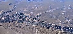
An aerial view of the Arkansas River near Fowler
-
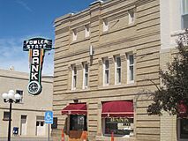
The Fowler State Bank building
-
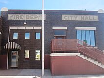
The Fowler Fire Department and City Hall on U.S. Highway 50
-
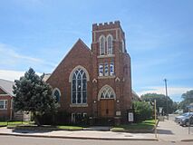
The First Methodist Church in Fowler
-
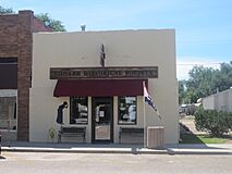
The Fowler Historical Society building


See also
 In Spanish: Fowler (Colorado) para niños
