La Junta, Colorado facts for kids
Quick facts for kids
La Junta, Colorado
|
|||
|---|---|---|---|

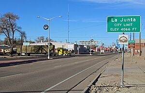
Looking west along East 1st Street
|
|||
|
|||

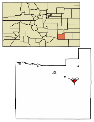
Location of the City of La Junta in Otero County, Colorado.
|
|||
| Country | United States | ||
| State | Colorado | ||
| County | Otero County | ||
| City | La Junta | ||
| Incorporated | April 23, 1881 | ||
| Government | |||
| • Type | Home Rule Municipality | ||
| Area | |||
| • Total | 3.18 sq mi (8.24 km2) | ||
| • Land | 3.18 sq mi (8.23 km2) | ||
| • Water | 0.01 sq mi (0.01 km2) | ||
| Elevation | 4,078 ft (1,243 m) | ||
| Population
(2020)
|
|||
| • Total | 7,322 | ||
| • Density | 2,303/sq mi (888.6/km2) | ||
| Time zone | UTC−7 (Mountain (MST)) | ||
| • Summer (DST) | UTC−6 (MDT) | ||
| ZIP code |
81050
|
||
| Area code(s) | 719 | ||
| FIPS code | 08-42110 | ||
| GNIS feature ID | 0204829 | ||
La Junta is a city in southeastern Colorado, United States. It is the main city in Otero County, Colorado. In 2020, about 7,322 people lived there. La Junta is located on the Arkansas River, about 68 miles (109 km) east of Pueblo. The city is also home to Otero College.
Contents
History of La Junta
La Junta means "the junction" in Spanish. The city got its name because it was a meeting point. It was where the famous Santa Fe Trail crossed a path leading to Pueblo. The town grew close to Bent's Fort, which was an important trading post in the 1800s.
During World War II, there was an Army Air Force Training Base near La Junta. Pilots learned how to fly there. Later, new flight simulators were invented. These simulators made it so pilots didn't need to do as much live flight training.
Geography and Climate
La Junta is in a dry area with short grass and sagebrush. This part of Colorado is often very warm. In summer, temperatures can go above 100°F (38°C) many times. The hottest temperature ever recorded in La Junta was 110°F (43°C). This happened on June 28, 1990, and again on June 24, 2012. The coldest temperature was -23°F (-31°C) on January 20, 1948.
| Climate data for La Junta Municipal Airport, Colorado (1991–2020 normals, extremes 1945–present) | |||||||||||||
|---|---|---|---|---|---|---|---|---|---|---|---|---|---|
| Month | Jan | Feb | Mar | Apr | May | Jun | Jul | Aug | Sep | Oct | Nov | Dec | Year |
| Record high °F (°C) | 78 (26) |
86 (30) |
90 (32) |
95 (35) |
104 (40) |
110 (43) |
109 (43) |
108 (42) |
108 (42) |
95 (35) |
86 (30) |
81 (27) |
110 (43) |
| Mean maximum °F (°C) | 68.8 (20.4) |
72.9 (22.7) |
82.1 (27.8) |
88.0 (31.1) |
95.5 (35.3) |
102.9 (39.4) |
104.5 (40.3) |
102.3 (39.1) |
98.2 (36.8) |
90.1 (32.3) |
78.2 (25.7) |
68.6 (20.3) |
105.7 (40.9) |
| Mean daily maximum °F (°C) | 46.5 (8.1) |
50.5 (10.3) |
61.3 (16.3) |
68.8 (20.4) |
78.8 (26.0) |
90.0 (32.2) |
94.5 (34.7) |
91.8 (33.2) |
84.3 (29.1) |
70.5 (21.4) |
56.9 (13.8) |
46.2 (7.9) |
70.0 (21.1) |
| Daily mean °F (°C) | 32.3 (0.2) |
35.9 (2.2) |
45.5 (7.5) |
53.2 (11.8) |
63.4 (17.4) |
74.2 (23.4) |
79.1 (26.2) |
76.8 (24.9) |
68.6 (20.3) |
54.6 (12.6) |
41.8 (5.4) |
32.3 (0.2) |
54.8 (12.7) |
| Mean daily minimum °F (°C) | 18.1 (−7.7) |
21.3 (−5.9) |
29.6 (−1.3) |
37.7 (3.2) |
48.0 (8.9) |
58.4 (14.7) |
63.6 (17.6) |
61.8 (16.6) |
52.9 (11.6) |
38.8 (3.8) |
26.8 (−2.9) |
18.4 (−7.6) |
39.6 (4.2) |
| Mean minimum °F (°C) | 0.1 (−17.7) |
3.7 (−15.7) |
13.8 (−10.1) |
23.2 (−4.9) |
34.5 (1.4) |
48.0 (8.9) |
55.8 (13.2) |
54.2 (12.3) |
39.2 (4.0) |
22.6 (−5.2) |
10.5 (−11.9) |
−0.9 (−18.3) |
−5.2 (−20.7) |
| Record low °F (°C) | −23 (−31) |
−20 (−29) |
−17 (−27) |
10 (−12) |
22 (−6) |
38 (3) |
48 (9) |
43 (6) |
22 (−6) |
0 (−18) |
−11 (−24) |
−21 (−29) |
−23 (−31) |
| Average precipitation inches (mm) | 0.21 (5.3) |
0.25 (6.4) |
0.71 (18) |
1.22 (31) |
1.59 (40) |
1.31 (33) |
2.21 (56) |
1.43 (36) |
0.84 (21) |
0.94 (24) |
0.37 (9.4) |
0.26 (6.6) |
11.34 (288) |
| Average precipitation days (≥ 0.01 in) | 3.1 | 3.1 | 5.3 | 6.2 | 7.4 | 6.6 | 8.0 | 7.5 | 4.8 | 4.3 | 3.4 | 2.6 | 62.3 |
| Source: NOAA | |||||||||||||
Population of La Junta
| Historical population | |||
|---|---|---|---|
| Census | Pop. | %± | |
| 1890 | 1,439 | — | |
| 1900 | 2,513 | 74.6% | |
| 1910 | 4,154 | 65.3% | |
| 1920 | 4,964 | 19.5% | |
| 1930 | 7,193 | 44.9% | |
| 1940 | 7,040 | −2.1% | |
| 1950 | 7,712 | 9.5% | |
| 1960 | 8,026 | 4.1% | |
| 1970 | 8,205 | 2.2% | |
| 1980 | 8,338 | 1.6% | |
| 1990 | 7,637 | −8.4% | |
| 2000 | 7,568 | −0.9% | |
| 2010 | 7,077 | −6.5% | |
| 2020 | 7,322 | 3.5% | |
| U.S. Decennial Census 2020 | |||
In 2000, there were 7,568 people living in La Junta. There were almost 3,000 households. About 34% of these households had children under 18 living with them. The average household had about 2.44 people.
The population was spread out by age. About 27% of the people were under 18 years old. The median age was 36 years. This means half the people were younger than 36, and half were older.
Fun Things to See and Do
La Junta has many interesting places to visit. In the fall, from September to October, you can sometimes see tarantulas. They come out looking for mates when the weather gets cooler.
Just northeast of La Junta is Bent's Old Fort National Historic Site. This was a very important trading post along the Santa Fe Trail long ago. It's a great place to learn about history.
At Otero College, you can visit the Koshare Indian Museum. It has a large collection of items from Native American cultures. The museum also has a special program for Boy Scouts. The Scouts learn traditional Native American dances and how to make their own outfits. They even put on dance shows in the summer!
South of La Junta, you can find the Purgatoire River track site. This is one of the biggest places in North America where you can see dinosaur footprints!
The State Bank in La Junta was started in 1893. It has a unique drive-through that looks like a railroad caboose. The bank building itself has old-fashioned decorations and a teller line from the 1890s.
News and Radio
La Junta has its own daily newspaper called The Tribune-Democrat. You can also listen to local radio stations, KBLJ 1400 AM and KTHN 92.1 FM.
Getting Around La Junta

La Junta used to have a big railroad yard. This is where freight trains were put together before they climbed over Raton Pass. Today, the Southwest Chief is a major train that passes through La Junta. It travels between Los Angeles and Chicago.
Several highways go through La Junta. U.S. Highway 50 comes from Pueblo and continues east towards Kansas. U.S. Highway 350 starts in La Junta and goes southwest. State Highway 10 also begins here and heads west.
The city has a public bus system that goes around town. For longer trips, you can use Bustang, which connects La Junta to other cities like Lamar, Pueblo, and Colorado Springs.
There's also a former military airport about 5 miles (8 km) north of La Junta. It has two runways, one is 6,851 feet (2,088 m) long and the other is 5,800 feet (1,768 m) long.
Famous People from La Junta
See also
 In Spanish: La Junta (Colorado) para niños
 | Tommie Smith |
 | Simone Manuel |
 | Shani Davis |
 | Simone Biles |
 | Alice Coachman |


