
Raton Pass facts for kids
Quick facts for kids Ratón Pass |
|
|---|---|

Amtrak's Southwest Chief westbound out of the Raton Tunnel near the summit of Raton Pass
|
|
| Elevation | 7,834 ft (2,388 m) |
| Traversed by | Burlington Northern Santa Fe Railroad |
| Location | Colfax County, New Mexico and Las Animas County, Colorado, US |
| Coordinates | 36°59′28″N 104°29′12″W / 36.9911344°N 104.4866544°W |
| Topo map | Ratón |
|
Raton Pass
|
|

Looking north from the top of Raton Pass
|
|
| Nearest city | Trinidad, Colorado, Raton, New Mexico |
| Area | 1,520 acres (620 ha) |
| Built | 1866 |
| NRHP reference No. | 66000474 |
| Significant dates | |
| Added to NRHP | October 15, 1966 |
| Designated NHL | December 19, 1960 |

Location in Colorado

Location in New Mexico
|
|
Raton Pass is a mountain pass located on the border between Colorado and New Mexico in the western United States. It sits at an elevation of 7,834 feet (2,388 meters) above sea level. The pass is found on the eastern side of the Sangre de Cristo Mountains. It connects the towns of Trinidad, Colorado and Raton, New Mexico.
The name Raton means "mouse" in Spanish. This pass crosses a line of volcanic hills. It provides the most direct land route between the Arkansas River valley to the north and the upper Canadian River valley to the south. This southern route leads towards Santa Fe, New Mexico. Today, Interstate 25 and railroad tracks use this important pass.
Raton Pass is a very important historical landmark. It was a key part of the Santa Fe Trail. This trail was a major route in the 1800s. It helped people travel and settle between Kansas City, Missouri and Santa Fe. Because of its historical importance, it was named a National Historic Landmark in 1960.
Contents
History of Raton Pass
Raton Pass has a long and interesting history. It has been used by explorers, soldiers, and settlers for centuries.
Early Trails and Travelers
In 1821, Captain William Becknell created the path for the Santa Fe Trail through Raton Pass. This trail became very popular for trade and travel. Later, in 1846, during the Mexican–American War, General Stephen W. Kearny and his soldiers marched through the pass. They were on their way to New Mexico.
During the American Civil War, Raton Pass was a main route into New Mexico. It was safer because it avoided areas where Confederate soldiers were active. Later, a man named Richens Lacey Wootton built a toll road through the pass. This meant travelers had to pay a fee to use it.
Railroad Development
In the late 1800s, the Atchison, Topeka and Santa Fe Railway (AT&SF) used Raton Pass. It was their main way to get trains through the mountains. This route was so important that it led to conflicts. The AT&SF and the Denver and Rio Grande Railroad fought over it in the 1878–1879 Railroad Wars.
Building a railroad over the pass was tough. The tracks had to climb steep hills, with slopes up to 3.5%. At the highest point, the AT&SF built a tunnel. This tunnel is 7,588 feet above sea level. It is entirely within New Mexico, just a few feet south of the Colorado border.
Today, the BNSF Railway uses this route. BNSF took over the Santa Fe railroad in 1996. Amtrak also uses the pass for its passenger trains. Amtrak's Southwest Chief travels between Chicago and Los Angeles. However, most freight trains now use a different route called the Belen Cutoff. This route was finished in 1908 and has much gentler slopes.
Modern Highway Route
In the 1900s, Raton Pass became a major highway route. It was first part of U.S. Route 85. Later, it became part of Interstate 25. This highway connects Denver and Albuquerque, New Mexico.
Driving over Raton Pass can be challenging. The road reaches 7,834 feet above sea level. This means it often gets heavy snow in winter. Sometimes, the pass has to close because of the weather.
Gallery
-
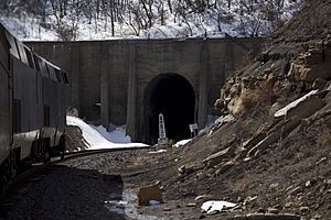
Amtrak's Southwest Chief entering the north end of the tunnel
-
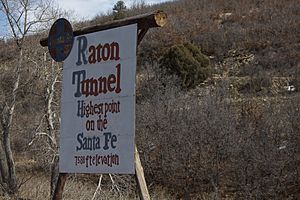
Sign marking the elevation of the Raton Pass tunnel


See also
 In Spanish: Paso Ratón para niños
