
Las Animas County, Colorado facts for kids
Quick facts for kids
Las Animas County
|
|
|---|---|
|
County
|
|

Las Animas County Courthouse in Trinidad
|
|

Location within the U.S. state of Colorado
|
|
 Colorado's location within the U.S. |
|
| Country | |
| State | |
| Founded | February 9, 1866 |
| Named for | Purgatoire River |
| Seat | Trinidad |
| Area | |
| • Total | 4,775 sq mi (12,370 km2) |
| • Land | 4,773 sq mi (12,360 km2) |
| • Water | 2.7 sq mi (7 km2) 0.06% |
| Population
(2020)
|
|
| • Total | 14,555 |
| • Density | 3/sq mi (1/km2) |
| Time zone | UTC−7 (Mountain) |
| • Summer (DST) | UTC−6 (MDT) |
| Area code | 719 |

Las Animas County is a large county located in the U.S. state of Colorado. As of the 2020 census, about 14,555 people live there. The main city and county seat is Trinidad. The county gets its name from the Purgatoire River. Its original Spanish name, El Río de las Ánimas Perdidas en el Purgatorio, means "River of the Lost Souls in Purgatory."
Contents
Geography of Las Animas County
Las Animas County is the largest county in Colorado by land area. It covers about 4,775 square miles (12,367 square kilometers). Most of this area is land, with only a small part being water.
Neighboring Counties
Las Animas County shares borders with several other counties:
- Otero County to the north
- Pueblo County to the north
- Bent County to the northeast
- Baca County to the east
- Union County, New Mexico to the south
- Colfax County, New Mexico to the southwest
- Costilla County to the west
- Huerfano County to the northwest
Major Roads and Highways
Several important roads run through Las Animas County, connecting its communities and leading to other parts of Colorado and beyond:
 Interstate 25
 I-25 Bus.
 I-25 Bus.
 U.S. Highway 160
 U.S. Highway 350
 State Highway 12
 State Highway 109
 State Highway 389
Parks and Protected Areas
Las Animas County is home to several natural and protected areas where people can enjoy the outdoors:
- Comanche National Grassland
- Lake Dorothey State Wildlife Area
- James M. John State Wildlife Area
- San Isabel National Forest
- Spanish Peaks Wilderness
- Fishers Peak State Park
- Trinidad Lake State Park
Historical Sites and Trails
The county has many places that tell stories of its past:
- Mesa de Maya
- Raton Pass National Historic Landmark
- Santa Fe National Historic Trail
- Trinidad State History Museum
Beautiful Driving Routes
You can explore the county's beauty by driving along these special routes:
- Highway of Legends Scenic Byway
- Santa Fe Trail National Scenic Byway
Population of Las Animas County
| Historical population | |||
|---|---|---|---|
| Census | Pop. | %± | |
| 1870 | 4,276 | — | |
| 1880 | 8,903 | 108.2% | |
| 1890 | 17,208 | 93.3% | |
| 1900 | 21,842 | 26.9% | |
| 1910 | 33,643 | 54.0% | |
| 1920 | 38,975 | 15.8% | |
| 1930 | 36,008 | −7.6% | |
| 1940 | 32,369 | −10.1% | |
| 1950 | 25,902 | −20.0% | |
| 1960 | 19,983 | −22.9% | |
| 1970 | 15,744 | −21.2% | |
| 1980 | 14,897 | −5.4% | |
| 1990 | 13,765 | −7.6% | |
| 2000 | 15,207 | 10.5% | |
| 2010 | 15,507 | 2.0% | |
| 2020 | 14,555 | −6.1% | |
| 2023 (est.) | 14,348 | −7.5% | |
| U.S. Decennial Census 1790-1960 1900-1990 1990-2000 2010-2020 |
|||
In 2020, the population of Las Animas County was 14,555 people. The county has a mix of different backgrounds, with a significant portion of the population being of Hispanic or Latino heritage. The average age of people living in the county is around 41 years old.
Communities in Las Animas County
Las Animas County has one main city and several smaller towns and communities.
City
Towns
Unincorporated Communities
These are smaller communities that are not officially part of a city or town:
Former Towns
These places were once towns but are no longer active communities:
Census-Designated Places
These are areas that are identified for census purposes but are not officially incorporated as cities or towns:
Images for kids
-
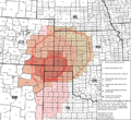
This map shows the area affected by the Dust Bowl in the 1930s.
-
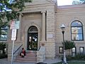
The Public library in Trinidad serves the people of Las Animas County.
-
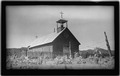
The Santa Nina de Atoche church in Tijeras Plaza, Las Animas County, around 1934.
-

A Philatelic cover with a postmark from Officer, Colorado, on its last day of service.
.svg)


See also
 In Spanish: Condado de Las Ánimas para niños
