Colfax County, New Mexico facts for kids
Quick facts for kids
Colfax County
|
||
|---|---|---|

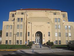
Colfax County Courthouse in Raton
|
||
|
||

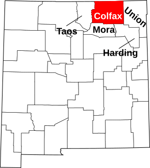
Location within the U.S. state of New Mexico
|
||
 New Mexico's location within the U.S. |
||
| Country | ||
| State | ||
| Founded | January 25, 1869 | |
| Named for | Schuyler Colfax | |
| Seat | Raton | |
| Largest city | Raton | |
| Area | ||
| • Total | 3,768 sq mi (9,760 km2) | |
| • Land | 3,758 sq mi (9,730 km2) | |
| • Water | 10 sq mi (30 km2) 0.3%% | |
| Population
(2020)
|
||
| • Total | 12,387 | |
| • Density | 3.3/sq mi (1.3/km2) | |
| Time zone | UTC−7 (Mountain) | |
| • Summer (DST) | UTC−6 (MDT) | |
| Congressional district | 3rd | |


Colfax County is a county located in the state of New Mexico, United States. In 2020, about 12,387 people lived there. The main town and government center, called the county seat, is Raton. Colfax County is just south of the Colorado state line. It was named after Schuyler Colfax, who was the seventeenth Vice President of the United States under President Ulysses S. Grant.
Colfax County is also home to two well-known places: Philmont Scout Ranch, a large high-adventure camp for Scouts, and the NRA Whittington Center, a big outdoor shooting sports and training facility.
Contents
History of Colfax County
Colfax County has an interesting past, including changes to its borders and where its main government office was located.
How Colfax County Was Formed
Colfax County was not always its own county. It was first part of Taos County, which was one of the first nine counties in the New Mexico Territory back in 1852. Later, in 1859, the eastern part of Taos County became Mora County. Finally, on January 25, 1869, Colfax County was officially created from the northern part of Mora County.
Moving the County Seat
The county seat is the town where the county's government offices are located. Colfax County's county seat moved several times:
- Elizabethtown: When Colfax County was first created, its county seat was Elizabethtown. This was a busy gold mining town at the time.
- Cimarron: By 1872, the gold rush slowed down. The county seat then moved to Cimarron. Cimarron was an important stop on the Santa Fe Trail, a famous old wagon route. It was also the main office for the huge Maxwell Land Grant. The old Colfax County Courthouse in Cimarron is now used by a Masonic lodge.
- Springer: In 1881, the county seat moved again, this time to Springer. Springer was located along the Atchison, Topeka, and Santa Fe Railroad, which was very important for travel and trade. The Colfax County Courthouse in Springer was a key location during the Colfax County War, a period of conflict over land rights. This old courthouse is now a museum about the Santa Fe Trail.
- Raton: After a big debate and a vote, the county seat moved from Springer to Raton in 1897. Raton was a major coal-mining town and a railroad hub. The people of Raton even helped pay for a new courthouse. The current Colfax County Courthouse (Raton, New Mexico) was built in 1932. It is an art-deco style building, partly built with help from the WPA during the Great Depression.
Changes to County Borders
In 1893, parts of Colfax, Mora, and San Miguel counties were used to create a new county called Union County.
Geography of Colfax County
Colfax County covers a large area of about 3,768 square miles. Most of this is land, with only a small part being water.
Landscapes and Nature
A big part of Colfax County is located in the Sangre de Cristo Mountains. The land here changes a lot, from wide-open prairies to forests filled with piñon trees, and even high-up alpine meadows. The county offers many outdoor activities. It has several state parks, places to ski, national forests, and beautiful views.
Neighboring Counties
Colfax County shares its borders with several other counties:
- Taos County - to the west
- Mora County - to the south
- Harding County - to the south
- Union County - to the east
- Las Animas County, Colorado - to the north
- Costilla County, Colorado - to the northwest
Protected Natural Areas
Several important natural areas are found partly within Colfax County:
- Carson National Forest
- Kiowa National Grassland
- Maxwell National Wildlife Refuge
People of Colfax County
The population of Colfax County has changed over the years. In 2020, about 12,387 people lived there.
Population Details (2010)
According to the 2010 census, there were 13,750 people living in Colfax County.
- About 83.8% of the people were white.
- About 47.2% of the population identified as Hispanic or Latino.
- The average age of people in the county was about 46.7 years old.
- The average income for a family was about $48,450 per year.
- About 17.2% of all people in the county lived below the poverty line. This included about 23.8% of those under 18 years old.
Towns and Communities
Colfax County has several towns and smaller communities.
Cities
- Raton (This is the county seat)
Towns
Villages
Census-Designated Places
- Ute Park
Other Communities
Many smaller, unincorporated communities are also part of Colfax County:
- Black Lake
- Carisbrook
- Colmar
- Dawson
- Dillon
- Elizabethtown
- Farley
- Miami
- Philmont Scout Ranch
- Rayado
- Sunny Side
- Sweetwater
- Van Houten
- Baldy Town
Former Communities
- Abbott
Education in Colfax County
Students in Colfax County attend schools in several different school districts:
- Cimarron Public Schools
- Des Moines Municipal Schools
- Maxwell Municipal Schools
- Raton Public Schools
- Springer Municipal Schools
See also
 In Spanish: Condado de Colfax (Nuevo México) para niños
 | George Robert Carruthers |
 | Patricia Bath |
 | Jan Ernst Matzeliger |
 | Alexander Miles |


