Dawson, New Mexico facts for kids
Quick facts for kids
Dawson, New Mexico
|
|
|---|---|

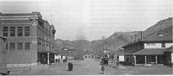
Main Street Dawson, 1916
|
|
| Country | United States |
| State | New Mexico |
| County | Colfax |
| Elevation | 6,339 ft (1,932 m) |
| Time zone | UTC-7 (Mountain (MST)) |
| • Summer (DST) | UTC-6 (MDT) |
| GNIS feature ID | 902230 |
Dawson (also called Mountview) is a ghost town in Colfax County, New Mexico, United States. It is located about 17 miles (27.4 km) northeast of Cimarron. Dawson was once a busy coal mining town. It was the site of two major coal mining accidents in 1913 and 1923. In 1950, the mines closed down. By 1954, the last people had left, and the post office closed. This made Dawson a ghost town.
Contents
How Dawson Started
Dawson and the land around it were once part of the Maxwell Land Grant. In the late 1860s, Lucien B. Maxwell sold a large piece of land, over 24,000 acres (97 sq km), to John Barkley Dawson. He sold it for $3,700. John Dawson and his brother L.S. Dawson settled there in 1867. Later, a company tried to take the land from Dawson. But a court in 1901 said that Dawson owned it.
Coal Discovery and Growth
Coal was found on the land in 1895. In 1901, Dawson sold the land to C.B. Eddy for $400,000. Eddy and his partners started the Dawson Fuel Company. They built the Dawson Railroad from Tucumcari to the mine site. In 1905, Eddy sold the mines and railroad to the Phelps Dodge Company. Phelps Dodge was interested in the coal because it was good for coking. Coking is a process that makes coal suitable for steelmaking, which was part of their business.
The company needed workers for this remote place. So, they built homes for the miners. They also built many other facilities. These included a hospital, a large store, a swimming pool, a movie theater, and even a golf course. These comforts helped Phelps Dodge keep workers. This was important despite the dangers of mining and the town's isolated location. Many miners were new immigrants to the country. By 1913, Dawson's population grew to 6,000 people.
Mining Operations
Dawson had ten coal mines, numbered 1 through 10. They were often called "Stag Canyon #" mines. Some mines were connected to the coal processing plants in Dawson. They used an electric-powered narrow gauge railroad. This railroad was about 6,600 feet (2,011.7 meters) long. It ran along Rail Canyon to mines 1, 2, 3, 4, and 6. Mines 5 and 7 also connected underground.
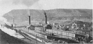
Mines 8, 9, and 10 were southwest of Dawson. They had their own coal cleaning and loading facilities. These mines also used an electric railroad inside them. The coal was cleaned and sorted for different uses. There were also coking ovens. These ovens turned coal into coke for metal processing. The coking ovens produced gas. This gas was burned to create steam. The steam generated electricity for mine machines and lights in the mines and towns.
Railroad Connections
Phelps Dodge also bought the Dawson Railway. It became part of their El Paso and Southwestern Railroad system. Later, the Southern Pacific Railroad bought the EP&SW. They also bought long-term contracts for coal from Dawson. Southern Pacific mostly used oil to fuel their steam locomotives. However, their division in Tucumcari used coal-fueled steam engines. These were the only ones of their kind on their railroad.
Baseball in Dawson
In 1912, Dawson even had a minor league baseball team. The Dawson Stags joined the Class D level Rocky Mountain League. The league started with four teams. The Colorado Springs team moved to Dawson on June 15, 1912. The Rocky Mountain League stopped playing after the 1912 season.
Mining Disasters
Dawson faced two terrible mining disasters that cost many lives.
1913 Mine Explosion
On October 22, 1913, Dawson had its first big disaster. An explosion shook Stag Canyon Mine No. 2. It was felt two miles (3.2 km) away in town. Rescue teams came from nearby towns and even far away. But out of 286 men who went to work that morning, only 23 survived. Most of the 263 people who died were from Hispanic backgrounds, Italy, and Greece. One survivor, George Mavroidis, saw 16 men die around him. He woke up the next morning in the mine office.
Phelps Dodge sent a special train with doctors and nurses. But it was too late for most. Among those who died, 146 were Italian and 36 were Greek. Two rescuers also died. It was later found that a dynamite charge caused the explosion. It set off coal dust in the mine. This was against mining safety rules. The other mines kept working after this disaster.
1923 Mine Explosion
In 1923, another mine explosion killed 123 miners. On February 8, Stag Canyon Mine No. 1 exploded. A mine car went off its tracks. It knocked down wooden supports and the electric trolley cable. This caused sparks, which ignited coal dust in the mine. Many of the miners who died were descendants of those killed in the 1913 accident.
Why Dawson Became a Ghost Town
Dawson became a ghost town in 1950. This is when the Phelps Dodge Corporation closed the mines. Mine 6 was the biggest producer when they closed. Other mines had closed earlier because there was less demand for coal. The main reason for the closures was that a 25-year coal contract with the Southern Pacific Railroad ended. The entire town was then sold or torn down. Some miners' houses were moved to other places.
The Southern Pacific railroad line to Tucumcari was also removed around this time. But in 1965, the northern part of the old railroad path was used again. The Santa Fe Railroad built new tracks there. These tracks went through Dawson and continued about 15 miles (24.1 km) to a new mine in York Canyon. This open-pit mine was first run by Kaiser Steel. Its coal was sent to their steel mill in Fontana, California. The York Canyon mine was operated by different companies. It finally closed in the early 2000s. As of 2016, the railroad tracks were still there.
Dawson Today
Most of the town of Dawson is now gone. Only a few buildings remain. The tall smoke stacks from the coking ovens were taken down in the early 2000s. They were removed because they were a safety concern for the property owner.
The most important landmark left in Dawson is the Dawson Cemetery. It is listed on the National Register of Historic Places. The cemetery has many white iron crosses. These mark the graves of miners who died in the accidents. Other markers show where other Dawson residents are buried.
You can reach Dawson by taking Route 64. Drive about 12 miles (19.3 km) east of Cimarron. Then, turn north onto A38 at a striped sign. Continue on that road for about 5 miles (8.1 km). After A38 crosses the railroad tracks a second time, turn onto the dirt road on the right. This road goes east of A38 for about 1,000 feet (304.8 meters) to the Dawson cemetery. You can see the ruins of Dawson by continuing north on A38. This road turns into Barus Road and then splits into Lauretta Road and Rail Canyon Road.
Notable Person
- Dolores Huerta (born 1930), a labor leader and activist, was born in Dawson. She received the Presidential Medal of Freedom.
 | John T. Biggers |
 | Thomas Blackshear |
 | Mark Bradford |
 | Beverly Buchanan |


