Costilla County, Colorado facts for kids
Quick facts for kids
Costilla County
|
|
|---|---|

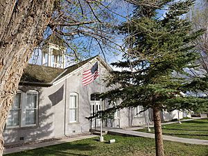
The Costilla County Courthouse in San Luis
|
|

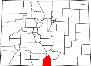
Location within the U.S. state of Colorado
|
|
 Colorado's location within the U.S. |
|
| Country | |
| State | |
| Founded | November 1, 1861 |
| Seat | San Luis |
| Largest town | San Luis |
| Area | |
| • Total | 1,230 sq mi (3,200 km2) |
| • Land | 1,227 sq mi (3,180 km2) |
| • Water | 3.4 sq mi (9 km2) 0.3%% |
| Population
(2020)
|
|
| • Total | 3,499 |
| • Density | 2.9/sq mi (1.1/km2) |
| Time zone | UTC−7 (Mountain) |
| • Summer (DST) | UTC−6 (MDT) |
| Congressional district | 3rd |
| Colorado's first permanent settlement | |
Costilla County (which means "rib" in Spanish) is a county located in the U.S. state of Colorado. In 2020, about 3,499 people lived there. The county seat (the main town for county government) is San Luis. San Luis is the oldest town in Colorado where people have lived without interruption.
Contents
History of Costilla County
Spanish explorers reached the area that is now Costilla County a long time ago. In 1664, Juan de Archuleta led the first known Spanish trip into Colorado. Later, in 1694, Don Diego de Vargas and his army also explored this region.
Costilla County was the first part of Colorado where people from Europe settled. The county was a big part of the Sangre de Cristo Land Grant. This land was given to the Carlos Beaubien family by the New Mexico government in 1843. Hispanic settlers from Taos, New Mexico, officially started the town of San Luis on April 9, 1851.
Costilla County was one of the first 17 counties created in the Territory of Colorado. This happened on November 1, 1861. The county got its name from Costilla Creek. At first, San Miguel was the county seat. But the county government moved to San Luis in 1863. Later, surveys showed that San Miguel was actually in the New Mexico Territory.
The county's first borders covered a large area of south-central Colorado. Over time, parts of it became new counties. In 1866, a northern part became Saguache County. In 1874, western parts became Hinsdale and Rio Grande counties. Costilla County got its current shape in 1913 when Alamosa County was created from its northwest sections.
Geography of Costilla County
Costilla County covers about 1,230 square miles (3,186 square kilometers). Most of this area is land, with a small amount of water.
Neighboring Counties
Costilla County shares borders with these other counties:
- Huerfano County - to the northeast
- Las Animas County - to the east
- Colfax County, New Mexico - to the southeast
- Taos County, New Mexico - to the south
- Conejos County - to the west
- Alamosa County - to the northwest
Main Roads
 U.S. Highway 160
 State Highway 142
 State Highway 159
Protected Natural Areas
Historic Trails and Places
- Fort Garland State History Museum
- Los Caminos Antiguos Scenic and Historic Byway
- Old Spanish National Historic Trail
Population of Costilla County
| Historical population | |||
|---|---|---|---|
| Census | Pop. | %± | |
| 1870 | 1,779 | — | |
| 1880 | 2,879 | 61.8% | |
| 1890 | 3,491 | 21.3% | |
| 1900 | 4,632 | 32.7% | |
| 1910 | 5,498 | 18.7% | |
| 1920 | 5,032 | −8.5% | |
| 1930 | 5,779 | 14.8% | |
| 1940 | 7,533 | 30.4% | |
| 1950 | 6,067 | −19.5% | |
| 1960 | 4,219 | −30.5% | |
| 1970 | 3,091 | −26.7% | |
| 1980 | 3,071 | −0.6% | |
| 1990 | 3,190 | 3.9% | |
| 2000 | 3,663 | 14.8% | |
| 2010 | 3,524 | −3.8% | |
| 2020 | 3,499 | −0.7% | |
| 2023 (est.) | 3,628 | 3.0% | |
| U.S. Decennial Census 1790-1960 1900-1990 1990-2000 2010-2020 |
|||
In 2000, there were 3,663 people living in Costilla County. The population density was about 3 people per square mile. Many households had children under 18. The average household had about 2.44 people.
The population included people of different ages. About 25% were under 18 years old. The median age was 42 years. This means half the people were younger than 42 and half were older.
Communities in Costilla County
Towns
Census-Designated Places
These are areas that are like towns but are not officially incorporated as towns.
Other Unincorporated Places
These are smaller communities that are not part of any town or census-designated place.
See also
 In Spanish: Condado de Costilla para niños
 | Kyle Baker |
 | Joseph Yoakum |
 | Laura Wheeler Waring |
 | Henry Ossawa Tanner |

