Rio Grande County, Colorado facts for kids
Quick facts for kids
Rio Grande County
|
|
|---|---|

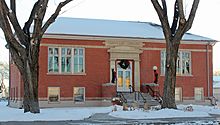
Carnegie Library (Monte Vista, Colorado)
|
|

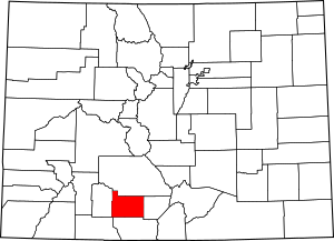
Location within the U.S. state of Colorado
|
|
 Colorado's location within the U.S. |
|
| Country | |
| State | |
| Founded | February 10, 1874 |
| Named for | Rio Grande |
| Seat | Del Norte |
| Largest city | Monte Vista |
| Area | |
| • Total | 912 sq mi (2,360 km2) |
| • Land | 912 sq mi (2,360 km2) |
| • Water | 0.4 sq mi (1 km2) 0.04%% |
| Population
(2020)
|
|
| • Total | 11,539 |
| • Estimate
(2023)
|
11,188 |
| • Density | 12.652/sq mi (4.8851/km2) |
| Time zone | UTC−7 (Mountain) |
| • Summer (DST) | UTC−6 (MDT) |
| Congressional district | 3rd |
Rio Grande County is a place in Colorado, USA. It's one of the many counties in the state. In 2020, about 11,539 people lived there. Its main town, or "county seat," is Del Norte. The county gets its name from the Rio Grande, a big river that flows right through it.
Contents
Exploring Rio Grande County
Rio Grande County is like a doorway to the beautiful San Juan Mountains. It's a special part of the San Luis Valley. The county covers about 913 square miles (2,365 km²). Its land goes from about 7,000 feet (2,134 meters) high in the valley to peaks over 13,000 feet (3,962 meters) tall.
There are three main towns in the county:
All these towns grew up along the railroad tracks that follow the Rio Grande river.
Monte Vista: The Farming Hub
Monte Vista is the biggest town in the county. It sits on the valley floor. Locals often call it "Monte." This town is the center for farming in the county. Many fun festivals, events, and clubs happen in and around Monte Vista. The Monte Vista National Wildlife Refuge is also nearby. It's a key stop for Sandhill Cranes when they migrate each year.
Del Norte: A Glimpse into History
Del Norte is a charming town. It focuses on its rich history. It is the county seat, meaning it's where the county government is located. Del Norte is home to the Rio Grande County Museum. Its main street still looks like it did long ago, keeping its historic feel.
South Fork: Mountain Adventures
South Fork is the newest town in Rio Grande County. It is surrounded by the Rio Grande National Forest and other public lands. This means it's easy to get to nature and outdoor activities. The Wolf Creek Ski Area is also close by. South Fork started as a logging town. Now, it's a wonderful place with a growing housing market. It has a great 18-hole golf course. South Fork is also known as the "Gateway to the Silver Thread" scenic byway.
Geography and Nature
Rio Grande County covers a total area of about 912 square miles (2,362 km²). Most of this is land, with only a tiny bit (0.4 square miles or 1 km²) being water.
Neighboring Counties
Rio Grande County shares its borders with these other counties:
- Saguache County to the north
- Alamosa County to the east
- Conejos County to the south
- Archuleta County to the southwest
- Mineral County to the west
Main Roads
Several important highways run through Rio Grande County:
 U.S. Highway 160
 U.S. Highway 285
 State Highway 15
 State Highway 112
 State Highway 149
 State Highway 368
 State Highway 370
Protected Natural Areas
The county is home to important natural areas that are protected:
Trails and Scenic Drives
You can explore these famous trails and byways in the county:
- Continental Divide National Scenic Trail
- Old Spanish National Historic Trail
- Silver Thread Scenic Byway
Population and People
| Historical population | |||
|---|---|---|---|
| Census | Pop. | %± | |
| 1880 | 1,944 | — | |
| 1890 | 3,451 | 77.5% | |
| 1900 | 4,080 | 18.2% | |
| 1910 | 6,563 | 60.9% | |
| 1920 | 7,855 | 19.7% | |
| 1930 | 9,953 | 26.7% | |
| 1940 | 12,404 | 24.6% | |
| 1950 | 12,832 | 3.5% | |
| 1960 | 11,160 | −13.0% | |
| 1970 | 10,494 | −6.0% | |
| 1980 | 10,511 | 0.2% | |
| 1990 | 10,770 | 2.5% | |
| 2000 | 12,413 | 15.3% | |
| 2010 | 11,982 | −3.5% | |
| 2020 | 11,539 | −3.7% | |
| 2023 (est.) | 11,188 | −6.6% | |
| U.S. Decennial Census 1790-1960 1900-1990 1990-2000 2010-2020 |
|||
In 2000, about 12,413 people lived in Rio Grande County. There were 4,701 households, which are groups of people living together. About 3,417 of these were families. The county had about 14 people per square mile (5 people per km²).
The people living in the county came from many different backgrounds. About 74% were White, and about 42% were of Hispanic or Latino heritage. About 28% of the people were under 18 years old. The average age was 37 years.
Towns and Communities
Rio Grande County has several towns and communities.
Cities
Towns
- Center (most of this town is in Saguache County)
- Del Norte
- South Fork
Census-Designated Places
These are areas that are like towns but are not officially incorporated:
Unincorporated Areas
These are smaller communities that are not part of any official city or town:
See also
 In Spanish: Condado de Río Grande para niños
 | Roy Wilkins |
 | John Lewis |
 | Linda Carol Brown |

